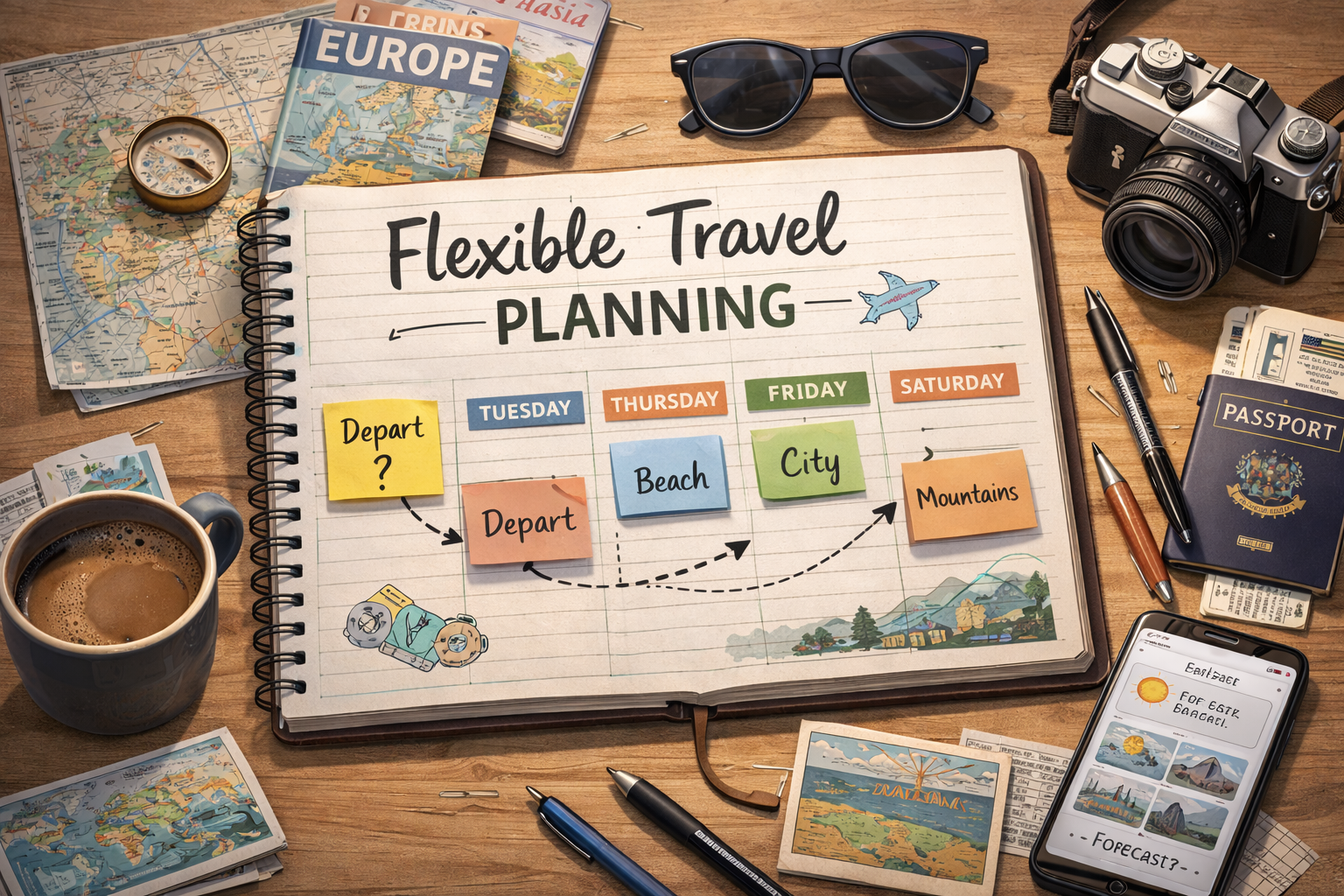
Welcome to France
Crossing a border:
Country No. 3 →
Arriving at the French Border
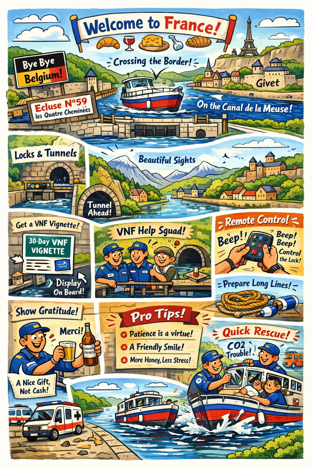
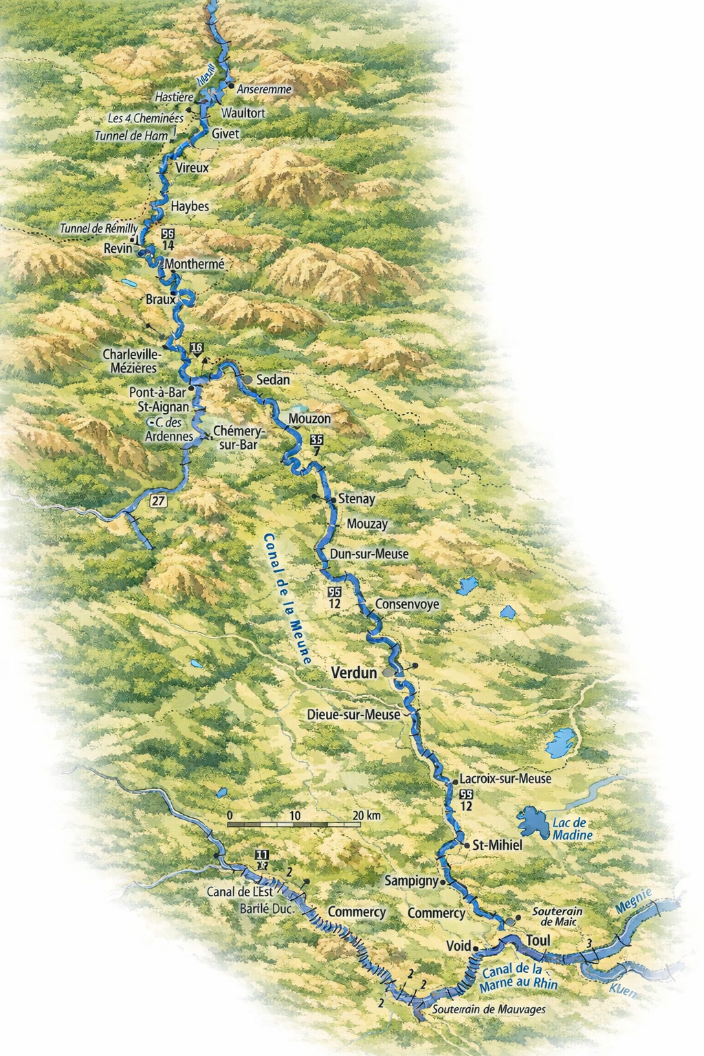
After leaving Dinant, the journey toward France is surprisingly short. In just about 2.5 hours of relaxed cruising, you will reach the French border on the Meuse. This is at Écluse French for "lock" — a chamber used to raise or lower vessels between water sections at different levels. French inland waterways have many écluses, often operated by resident lock-keepers (éclusiers) or remotely. N°59 les Quatre Cheminees, located just a few kilometers upstream of Dinant. It is a quiet but significant (and important) milestone, marking the transition from Belgian to French inland waterways.
So, France, land of wine and croissants, is one of the countries where the route travels a lot of kilometers. Leaving Écluse N°59 les Quatre Cheminees, passing Givet, the route will lead over major french waterways
Once passing Écluse N°59 les Quatre Cheminees at the border, the character of the river subtly changes. The Meuse becomes slightly narrower and more intimate, with the landscape closing in a little. The banks are greener and more wooded, and villages tend to sit closer to the water. Navigation remains straightforward, but you will notice an increase in the number of locks. And not only locks! You will find yourself navigating tunnels too.
These French locks are generally smaller and more frequent than those on the Belgian stretch of the river. The vertical lift of the locks is considerably greater than that of the Belgian locks. Therefore we advise to keep long lines and fenders ready before entering those locks. While they are well maintained and efficiently operated, locks do influence daily planning. Even relatively short distances can take longer due to waiting times, the duration of the locking operation and lock operating hours. Preparing lines and fenders in advance makes transits smoother, especially for crews new to French waterways. (Although when you ended up here, you and your crew will be well prepared for the French waterways ahead of you!)
After passing Écluse N°59 les Quatre Cheminees we are now on the Canal de la Meuse and the planning is to make some stops, to see the beautiful places. This is where the mountains really start, and the route guides along bastions, castles and citadels. It is a very nice preview of what to expect later this journey. But it's not only mountains, there are also many historic towns and villages to visit!
Obtaining a 30-Day VNF Vignette

To cruise on French inland waterways, your boat must have a valid VNF Voies Navigables de France — the French public agency managing the inland waterway network. They operate locks, bridges, and tunnels, and issue navigation permits (vignettes) for recreational boaters. vignette. This is the official navigation permit issued by Voies Navigables de France. For visiting boaters, a 30-day vignette is a convenient option that allows unrestricted use of VNF-managed waterways for one month.
The vignette can be purchased online via the official VNF website. During the application process, you will be asked to provide basic details about your vessel, including its length, type, and registration information if applicable. After completing payment, the vignette is usually issued immediately as a downloadable PDF file.
Displaying the Vignette on Board
Once purchased, the vignette must be clearly displayed on board. French authorities and lockkeepers may check compliance, so visibility is important.
It is recommended to print the vignette, preferably in colour, and protect it using a waterproof sleeve or lamination. The vignette should be placed where it is easily visible from outside the vessel, such as inside a wheelhouse window, on a cabin window near the helm, or close to the vessel's registration markings.
With the vignette correctly displayed, you are free to enjoy French inland cruising, where smaller locks, quieter waterways, and a slower rhythm of travel define the experience.
The remote control
At the first lock you can ask for the remote control, which allows you to operate the lock yourself. This is a simple device that you can use to operate the lock yourself, without needing to wait for the lockkeeper. It is a great way to save time and have more control over your journey. However, it is important to note that not all locks may have this option available, and it is always best to check with the lockkeeper before attempting to use the remote control.
Worth the money!
While being Dutch, we always look for the cheapest proper solution available. And entering France, and paying (at first glance) serious money for a vignette, might be a semi unpleasant surprise. Until you start to notice what you get in return for this! Virtually you will have your 24/7 Technician/Lock master/Bridge master/Security guard assigned to you.
Along your way trough France, whenever there is something wrong, and your boat fits within the "Freycinet" measurements, the employees of the VNF will do anything within their power to make sure you can use the infrastructure. But not only that, they will take care of your safety too.
And besides this, they will come truly asap when you are stuck in/at a lock/bridge! But very important! Your boat has to fit within the Freycinet measurements. Also, when there is something going on with the object, they will do anything possible to fix the issue.
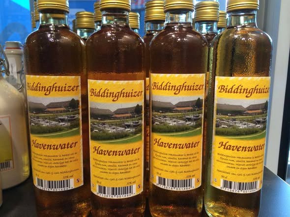
Pro Tip: If you want to show your gratitude and appreciation, the employees love to receive tokens of gratitude, rather than a tip in the form of money. Like in our case, a bottle of Harbor Water from Enkhuizen, might be one of those tokens. Naturally, comments can be found on the internet stating that they are unpleasant characters. However, a majority of people we spoke to are extremely positive about the employees. Points to consider are: Patience is a virtue, A friendly face brightens everything, Your stress won't solve the problem any faster, and You catch more flies with honey than with vinegar, Hasty Hurry is seldomly doing you a favor. (Just a few important old sayings).
Anekdote:The employees of the VNF will see if the next lock is opened by you. And if that is not the case, they will look along the stretch in between the two locks to see what is going on. Doing so, they found a boat on which the couple was overcome by CO2 and unconscious. The VNF employees arrived just in time to break the windows and get fresh air to the couple, while the fire department and ambulance had been alerted in the meantime. Thanks to this quick action by the VNF employee, the couple survived.
Permits and certificates you need in France!
Take this seriously!
Permits, Certificates and declarations
ICCInternational Certificate of CompetenceBCMRBasic Certificate Maritime Radio (Operator Certificate)
Radio Licence (Your registration of your Radio including callsign)ICPInternationaal Certificaat PleziervaartuigenPoOProof of Ownership or PurchaseInsuranceInsurance PolicyVATVAT DeclarationWaterways PermitFrench boating permit (VNF vignette)
For anyone navigating the French inland waterways with a boat longer than 5 meters and/or motorized above 9.9 hp, a VNF vignette is mandatory. You can apply for this vignette in advance via Vnf.fr (on the homepage click: "Achetez votre vignette plaisance"), but you can also buy one while en route at one of the locks near the French border. A 30-day vignette for our 8-meter vessel will cost about €119,10.
Maybe a bit old, but here you find the English PDF and the Dutch PDF
You can also directly go to the site to buy your vignette: https://vignettes-plaisance.vnf.fr/paiement-en-ligne/. The site supports the languages FR, EN, DE, NL.Make sure that you attach the permit on starboard frontside, visible under all circumstances.
Notice:
You cannot use any other permits (vignette) than the one provided by the VNF. Please read the PDF's for more information.
The French Canals
Detour, or not?
When you've watched the vlogs of the "Parel", you've seen that they had to make a detour because the Canal de la Meuse was obstructed because it was clogged with a lot of vegetation.... It added 140 km to their route. We don't plan to make that detour, but if needed, we have the information here. For both routes through France, we are going to put the (online) maps in the proper sequence here. One for the "normal" and one for the "detour" route.
Border between Belgium and France
Right before Écluse n.59 les Quatre Cheminees, the route takes us over the border from Belgium into France. At this lock you can also buy the formentioned VNF vignette. From this lock, we are heading towards Givet and therefore further into France.
Local stored information
We Dutch are not about re-inventing the wheel, so we are going to use the (very detailed) information found on french-waterways.com. This is a very nice site, with a lot of information regarding the french canals.
But we are also very aware that information can change, and therefore we have stored the relevant information from several sources here on our own site, so we always have access to it.
When you want the information we gathered ourselves, visit the local index page those routes.
Sources include, but are not limited to: EuRis, ElWis, VNF, waterkaarten.net and several local sources found on the internet.
Tunnels Tip: When entering a tunnel, report on VHF 10 indicating your direction, usually by reporting whether you are sailing upstream (montant) or downstream (avalant). In France (and Belgium), the standard call sign is for example:
"Bateau [Name boat], entre dans le souterrain de Ham, sens montant." (or sens avalant).
By doing this, you help other vessels in the tunnel to be aware of your presence and direction, which can enhance safety and coordination within the tunnel.
Local or Online Information
3rd party, or not?
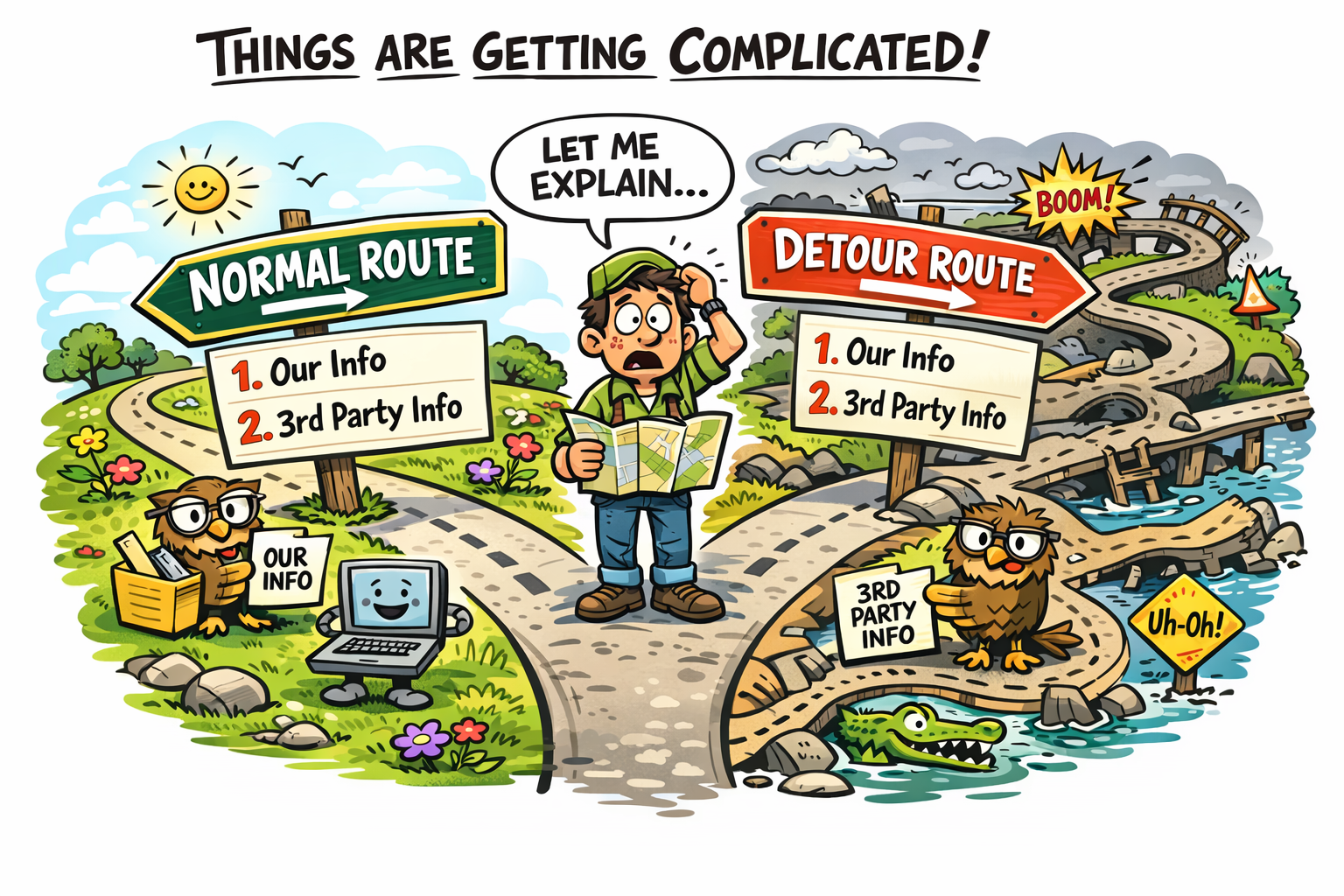
Complicated
From here on, things might become a bit complicated. Why? Let me explain. We have our information, and the information from a 3rd party website. (That is also very nice tho!) And there is the fact, that here is the normal route and the detour route:
- The normal route
- Our (local) information
- Third Party (another website) information
- The detour route
- Our (local) information
- Third Party (another website) information
Here we are, providing both local and online information. The local information is stored on our own site, so we always have access to it. The online information is from third-party sources like french-waterways.com.
So take your pick here:
The route(s) to Toul 🇫🇷
Detour, or not?
The Local Information
We are using here the same setup as we used in The Netherlands 🇳🇱 and the Belgium 🇧🇪 sections. We are using the same sources as we used in these previous sections, but we are also using some additional local information sources to complement the information used in the Netherlands 🇳🇱 and Belgium 🇧🇪 sections.
However, we are also aware that local conditions may change, and we have made sure to keep our information up to date.
And the advantage is that we can addd local information that is not available in the general sources, such as the VLOGS of the Parel.
Direct Route to Toul
The direct route to Toul is approx. 140 km shorter than the detour that the Parel had to make. It's unsure if we are able to take this route, or that we have to follow the same detour. When we have to take the detour, Ecluse n°40 de Dom-le-Mesnil will be the last lock we will pass before taking the detour. After Ecluse n°40 de Dom-le-Mesnil, we will have to take a right turn at KM 96.3 to get to the detour. The detour will lead us to the Canal des Ardennes, and from there we will follow the same route as the Parel took. The detour is approx. 140 km longer than the direct route, but it is also a very nice route to take. You enter the Canal des Ardennes, by passing PONT SUR TETE AVAL ECLUSE N°7 (km 0.1) and Ecluse n°7 de Meuse (km 0.15). Now jump to the detour section.
Detour Route to Toul
⚠️ Warning! The reason you may need to take the same detour as the Parel is excessive vegetation. Aquatic plants can grow densely in the river, making navigation difficult or even unsafe. This issue is particularly common during the summer months, when plant growth accelerates rapidly. It is strongly recommended to contact local authorities or experienced boaters in advance to check current conditions. Doing so will allow you to prepare in time and adjust your route if the detour becomes necessary.
⚠️ Heads up! If you are required to take the detour, continue along the normal route until you pass Écluse n°40 de Dom-le-Mesnil (during Day 4) and proceed to kilometre marker 96.3. This is the junction with the Canal des Ardennes. At this point, turn right to enter the canal. From there, follow the detour route to Toul, which is the same route taken by the Parel in episode 10 and following, of their vlog. The detour leads you via the Canal des Ardennes, the Canal latéral à l’Aisne, the Canal de l’Aisne à la Marne, and finally the Canal de la Marne au Rhin, where you rejoin the main route at kilometre 111.2. This alternative route is approximately 140 km longer than the direct route, but it is also considered a very scenic and enjoyable journey. For detailed navigation guidance, refer to the detour section.
Back to the Detour IndexTravel Days Explanation
We decided to split the direct route to Toul into travel days. This is based on the information we have and how mutch time we think we need to complete the route. We also want to take some time to enjoy the beautiful surroundings of the Meuse river, and visit the cities where we stop. Hence "travel days" instead of "travel sections". Per day we try to plan about 4 to 5 hours of navigating, which is about 30 to 40 km per day. This also gives us some time to do some sightseeing in the cities we stop at. And this way we can just stay as long as we want in the cities, and we don't have to worry about the next stop. We can just enjoy the city, and when we are ready, we can just continue to the next stop.
Canal de la Meuse
The routes to Toul
Canal de la Meuse
After crossing the border, we enter Ecluse n.59 les Quatre Cheminees before entering Givet.
Here the Meuse is already the Canal de la Meuse, but it is still the river.
The official canalisation of the Meuse starts at Ecluse n°40 de Dom-le-Mesnil.
Here we are not even close to taking the detour that the Parel had to
take.
From here, we will be going "on-off-on-off" on the Meuse and the side canals,
that make the Canal de la Meuse. Because parts are canalised, and some parts are still river.
From here on, we also will pass tunnels.
The canal is also known as the Canal de L'Est.
At (PK 272.4) Lock 1 (Troussey), is the juction with Canal de la Marne au Rhin.
This is at "48° 42′ 52.72″ N, 5° 41′ 23.76″ E"
Travel day 1 towards Toul
Day one: To Givet 🇫🇷
From Ecluse N°59 les Quatre Cheminees to Givet 🇫🇷
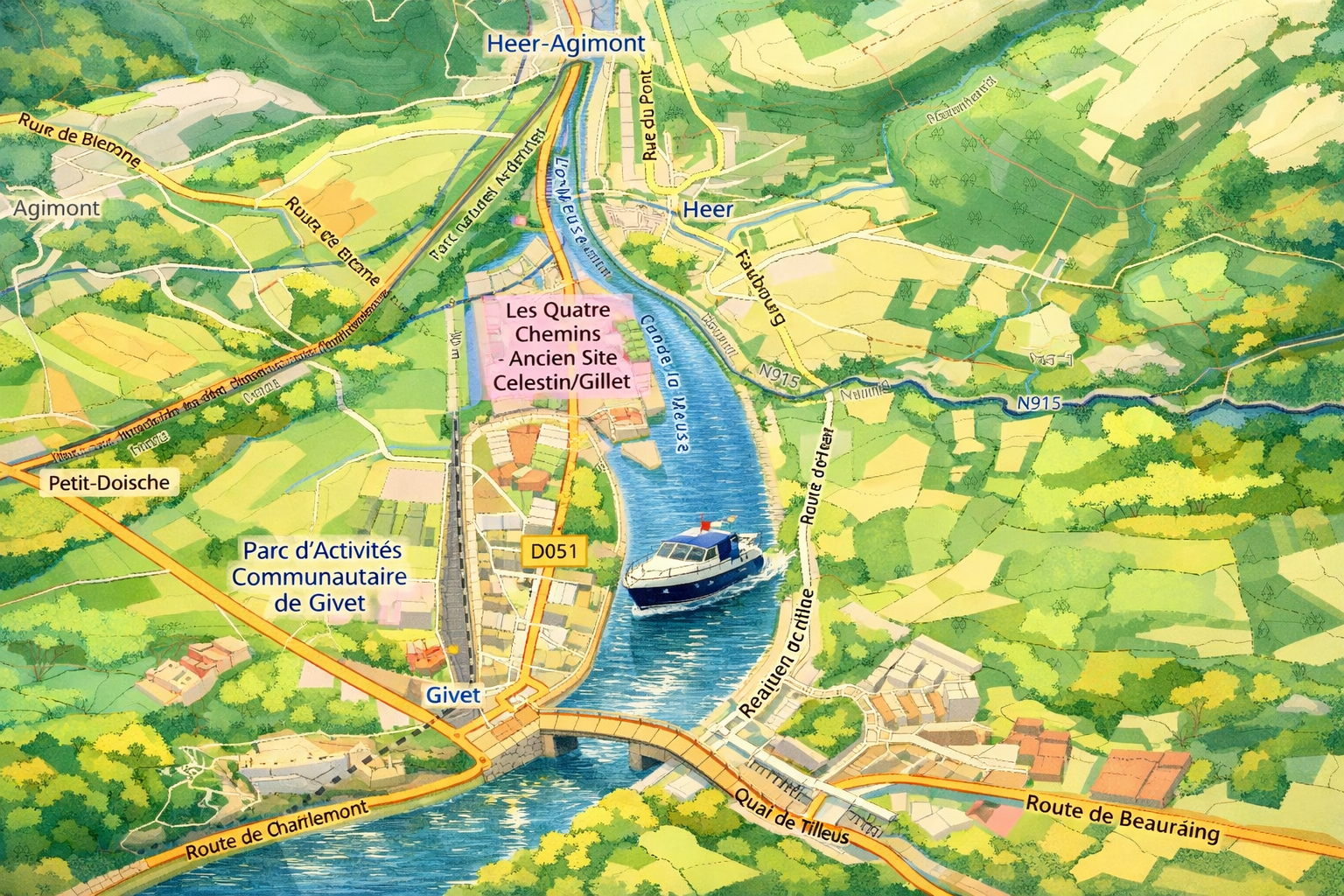
After entering the Canal de la Meuse, you will be on a direct route to Givet. The distance from the lock to Givet is approximately 4 km. This is also the first part of the direct route to Toul, and where the Parel stayed for the night.
There is a difference however, when the Parel was in Givet, they did moor on the left bank along the quay. Since their trip, there are floating docks on the right bank of the river, on the eastern side of Pont des Américains. The place is also referred to as Halte fluviale L'Escale Givet.
On this site you can find some interesting things about Givet and what you can visit.
The route of today
On this section of the route you will pass the objects:
Nearby Services - Halte fluviale L'Escale Givet
-
Closest Supermarket (Convenience): Carrefour City
Location: 6-7 Pl. de la République, Givet
Distance: Approx. 400m (5-minute walk on left bank)
Best for: Quick supplies and fresh groceries in the town center. -
Largest Supermarket: Intermarché SUPER
Location: Route de Beauraing, Givet
Distance: Approx. 1.5 km (15-20 minute walk right bank)
Best for: Bulk shopping and a wider variety of products. -
Nearest Gas Station: Intermarché Station-service
Location: Route de Beauraing (at the Intermarché supermarket)
Distance: Approx. 1.5 km (15-20 minute walk right bank)
Service: 24/7 automated pumps providing Diesel (Gazole) and Unleaded gas.
Note: Land-based station; accessible for fuel cans (jerrycans).
Travel day 2 towards Toul
Day two: To Revin 🇫🇷
From Givet 🇫🇷 to Revin 🇫🇷
Taking time on this stretch to enjoy the beautiful surroundings of the Meuse river. But also to prepare for the tunnels that are coming up. The first one is at Ham, and the second one is at Revin. In episode 8 of the VLOGS of the Parel, you can see how they prepare for the tunnels, and how they pass through the tunnels. After the tunnel at Revin, you will be in the Ardennes, and you will be closer to Toul. Exit the tunnel at Revin, take a starboard turn to get to the Quay at Revin where the Parel also stayed for the night.
The route of today
On this section of the route you will pass the objects:
Mooring at Revin 🇫🇷
Mooring at the Quay at Revin is on the right side of the canal, near the entrance to the tunnel. The Parel stayed here for the night. Coming out of the tunnel at Revin, Take a right turn to get to the Quay.
Nearby Services - Halte fluviale de Revin (Orzy)
-
Main Supermarket: Intermarché SUPER
Location: 13 Av. Danton, Revin
Distance: Approx. 250 m (5-minute walk on right bank)
Best for: Full grocery range and fresh local products. -
Alternative Market: Lidl
Location: Avenue de gal de Gaulle, Revin
Distance: Approx. 250 m (5-minute walk on right bank)
Best for: Budget-friendly groceries and essentials. -
Nearest Gas Station: Intermarché Station-service
Location: 13 Av. Danton (at Intermarché)
Distance: Approx. 250 m (5-minute walk on right bank)
Service: 24/7 automated pumps providing Diesel (Gazole) and Unleaded gas.
Note: Land-based station; easily accessible for fuel cans (jerrycans).
Travel day 3 towards Toul
Day three: To Charleville-Mézières 🇫🇷
From Revin 🇫🇷 to Charleville Mézières 🇫🇷
Taking time on this stretch to enjoy the beautiful surroundings of the Meuse river. But also to prepare for the tunnels that are coming up. The first one is at Ham, and the second one is at Revin. In episode 8 of the VLOGS of the Parel, you can see how they prepare for the tunnels, and how they pass through the tunnels. After the tunnel at Revin, you will be in the Ardennes, and you will be closer to Toul. Exit the tunnel at Revin, take a starboard turn to get to the Quay at Revin where the Parel also stayed for the night.
The route of today
On this section of the route you will pass the objects:
Mooring at Charleville-Mézières 🇫🇷
Mooring at Port de Plaisance de Charleville-Mézières makes that you have to make a right (starboard) turn when you exit the end of the lock-cut with Ecluse n°43 de Montcy. Follow the official riverbed upto 1.5 km from the canal you exited. On starboard side you will find the entrance to the Port de Plaisance de Charleville-Mézières. The Parel stayed here for the night. Continue the trip by returning this 1.5 km back to the canal.
Nearby Services - Port de Plaisance de Charleville-Mézières
-
Closest Supermarket (Convenience): Carrefour City
Location: 24 Rue de la République
Distance: Approx. 650m (8-minute walk on right bank)
Best for: Quick groceries and essentials near the Place Ducale. -
Large Supermarket: Carrefour Market
Location: 11 Rue de la Gravière
Distance: Approx. 1.1 km (14-minute walk on right bank)
Best for: A broader selection of products and fresh food. -
Nearest Gas Station: TotalEnergies Access
Location: 36 Avenue de Manchester
Distance: Approx. 1.2 km (15-minute walk on right bank)
Service: Automated pumps providing Diesel (Gazole) and Unleaded gas.
Note: Land-based station; accessible for fuel cans (jerrycans).
Travel day 4 towards Toul
Day four: To Sedan 🇫🇷
From Charleville-Mézières 🇫🇷 to Sedan 🇫🇷
Already day 4 on the Meuse: this is a good stretch to slow down, enjoy the scenery, and keep an eye on operational messages. Today’s planned stop is Sedan, home to the impressive Château de Sedan (often described as Europe’s largest medieval fortress).
One practical reason to stay flexible here is that the Canal de la Meuse (Meuse canalisée) is regularly constrained upstream from Verdun. The “upper” sector (often referred to as Meuse amont, roughly between Saint-Mihiel and Troussey) is sensitive to low-water conditions: long dry spells reduce inflow, while losses through the canal system make it harder to hold the navigation level across successive pounds. When water levels cannot be maintained safely, VNF may impose restrictions (reduced operating windows / grouped passages) or temporarily close parts of the route. Cerema – study on future water availability for the Canal de la Meuse and VNF – “Meuse amont” temporary operating rules (Avis à la batellerie FR/2025/04007) .
On top of that, the canalised reaches can suffer from heavy aquatic vegetation in summer: slower water, warm temperatures, and nutrient-rich conditions can produce dense weed mats that foul propellers and make steering unreliable. In practice, this is why you sometimes see “the canal is blocked” reports—even when the locks themselves are fine. (This is also why some guides actively encourage traffic on alternative branches to reduce stagnation and weed build-up.) French Waterways – Canal des Ardennes notes (weed-growth context) .
Detour decision point
Detour decision point (important): if you need to bypass a closure/weed problem that affects the upper Meuse later on (upstream of Verdun), you must commit earlier: after Écluse n°40 de Dom-le-Mesnil, continue to KM 96.3 and take the starboard/right turn into the Canal des Ardennes. This is the key junction where you leave the “normal” Meuse route and start the longer (but scenic) workaround. VNF – Avis à la batellerie search (check current closures/restrictions) .
The route(s) of today
On this section of the route you will pass the objects:
KM 96.3 The detour decision point
At this position you have to decide if you are going to make the turn towards Canal des Ardennes and Écluse n°40 de Dom-le-Mesnil. Use button here to get to the route-explanation for the detour
To the Detour IndexThe route(s) of today
On this section of the route you will pass the objects:
Mooring at Sedan 🇫🇷
Mooring at Port de Plaisance de Sedan makes that you have to make a left (port) turn when you exit the end of the lock-cut with Ecluse n°37. Right after the corner, the mooring places show. Several Grocery shops available.
Next stop: Port de plaisance De Stenay
Nearby Services - Aire Camping-Car Park Sedan
-
Closest Supermarket: Lidl
Location: Avenue du Maréchal Leclerc
Distance: Approx. 450m (6-minute walk)
Best for: Quick groceries and fresh bakery items right next to the site. -
Main Supermarket: Intermarché SUPER
Location: 2 Avenue de la Marne
Distance: Approx. 1 km (13-minute walk)
Best for: Large variety of products and local specialties. -
Nearest Gas Station: Intermarché Station-service
Location: 2 Avenue de la Marne (at Intermarché)
Distance: Approx. 1 km (13-minute walk)
Service: 24/7 automated pumps providing Diesel (Gazole) and Unleaded gas.
Travel day 5 towards Toul
Day five: To Stenay 🇫🇷
From Sedan 🇫🇷 to Stenay 🇫🇷
Starting day 5 on the Meuse. Taking time on this stretch to enjoy the beautiful surroundings of the Meuse river. Next stop is Stenay. In Stenay you will find the famous beer museum of Stenay, and you will be closer to Toul. This also deviates from the route the Parel took.
At Mouzon you can do groceries at a Carrefour Express supermarket. This a very basic supermarket, but it is the only one along todays route. So make sure to do your groceries here because it is unsure if you can do groceries in Stenay. So it is unsure if you can do groceries in Stenay, but it is better to be safe than sorry, so make sure to do your groceries in Mouzon.
The route of today
On this section of the route you will pass the objects:
Mooring at Stenay 🇫🇷
Mooring at Port de Plaisance de Stenay makes that you have to make a left (port) turn when you exit Ecluse regulatrice de Stenay. After 400 meters you will have to make a left turn to get to the mooring places. Right after the corner, the mooring places show.
Next stop: Port de plaisance Verdun
Nearby Services - Port de Plaisance de Stenay
-
Closest Supermarket: Lidl
Location: 1 Rue des Sorbiers, Stenay
Distance: Approx. 1.2 km (15-minute walk)
Best for: Groceries and fresh bakery items. -
Main Supermarket: Intermarché SUPER
Location: Zac des Cailloux, Stenay
Distance: Approx. 1.5 km (18-minute walk)
Best for: Large variety of products and extensive fresh departments. -
Nearest Gas Station: Intermarché Station-service
Location: Avenue de Verdun / Zac des Cailloux
Distance: Approx. 1.5 km (18-minute walk)
Service: 24/7 automated pumps providing Diesel (Gazole) and Unleaded gas.
Note: Land-based station; accessible for fuel cans (jerrycans).
Travel day 6 towards Toul
Day six: To Verdun 🇫🇷
From Stenay 🇫🇷 to Verdun 🇫🇷
Starting day 6 on the Meuse. Taking time on this stretch to enjoy the beautiful surroundings of the Meuse river. Next stop is Verdun. In Verdun you will find the famous museums of Verdun, and you will be closer to Toul. This also deviates from the route the Parel took.
At Verdun you can do groceries at supermarkets.
The route of today
On this section of the route you will pass the objects:
Mooring at Verdun 🇫🇷
Mooring at Port de Plaisance de Verdun makes that you have to make a left (port) turn when you exit Ecluse regulatrice de Verdun. After 400 meters you will have to make a left turn to get to the mooring places. Right after the corner, the mooring places show.
Next stop: Port de Saint Mihiel BIEF11
Nearby Services - Quai de Londres (Verdun Center)
-
Closest Supermarket (Convenience): Carrefour City
Location: 11 Rue Mazel, Verdun
Distance: Approx. 200m (3-minute walk on left bank)
Best for: Immediate groceries and fresh bread in the shopping street. -
Main Supermarket: Monoprix
Location: 26 Rue de l'Hôtel de Ville, Verdun
Distance: Approx. 450m (6-minute walk on left bank)
Best for: High-quality food products and general supplies. -
Nearest Gas Station: TotalEnergies Access
Location: 16 Avenue de Douaumont, Verdun
Distance: Approx. 1.2 km (15-minute walk)
Service: 24/7 automated pumps providing Diesel (Gazole) and Unleaded gas.
Note: Land-based station; accessible for fuel cans (jerrycans).
Travel day 7 towards Toul
Day seven: To Saint Mihiel 🇫🇷
From Verdun 🇫🇷 to Saint Mihiel 🇫🇷
Starting day 7 on the Meuse. Only 2 days aways from Toul. Taking time on this stretch to enjoy the beautiful surroundings of the Meuse river. Next stop is Saint Mihiel. In Saint Mihiel you will find the famous museums of Saint Mihiel, and you will be closer to Toul.
At Saint Mihiel you can do groceries at supermarkets. Also there is a gasstation about 10 minutes walk from the mooring place, so you can also do groceries there.
The route of today
On this section of the route you will pass the objects:
Mooring at Saint Mihiel 🇫🇷
Mooring at Port de Plaisance de Saint Mihiel is on the right banks of the river.
Next stop: Port de plaisance Toul
Nearby Services - Place du Souvenir Français (Saint-Mihiel)
-
Closest Supermarket: Carrefour Contact
Location: Avenue de la 40ème Division, Saint-Mihiel
Distance: Approx. 850m (11-minute walk on right bank)
Best for: Fresh produce, groceries, and daily essentials. -
Alternative Supermarket: Intermarché SUPER
Location: Rue de Saint-Christophe, Saint-Mihiel
Distance: Approx. 1.2 km (15-minute walk on right bank)
Best for: Larger shopping trips and a wider selection of goods. -
Nearest Gas Station: Intermarché Station-service
Location: Rue de Saint-Christophe (at Intermarché)
Distance: Approx. 1.2 km (15-minute walk)
Service: 24/7 automated pumps providing Diesel (Gazole) and Unleaded gas.
Travel day 8 towards Toul
Day eight: To Commercy 🇫🇷
From Saint Mihiel 🇫🇷 to Commercy 🇫🇷
Starting day 8 on the Meuse. The second to last stretch to Toul. Taking time on this stretch to enjoy the beautiful surroundings of the Meuse river. At Commercy we will get groceries, and we will prepare for the last stretch to Toul. This last stretch is a large set of locks, so want to make sure that we are well rested and prepared for this stretch.
The route of today
On this section of the route you will pass the objects:
Before we continue to Ecluse n°1 de Troussey 🇫🇷
Continue on the Canal de la Meuse upto Ecluse n°1 de Troussey to get on the Canal de la Marne au Rhin. This is the last stretch to Toul. The Canal de la Marne au Rhin will lead you to Toul, and it is also the canal that the Parel took to get to Toul. Also, the Lock is where the detour ends and the normal route continues. So if you had to take the detour, you will be back on the normal route at Ecluse n°1 de Troussey.
Nearby Services - Aire de Camping-Cars Commercy
-
Closest Supermarket: ALDI
Location: Rue du Docteur Boyer, Commercy
Distance: Approx. 100m (1-minute walk)
Best for: Immediate groceries and essentials right across the street. -
Main Supermarket: E.Leclerc
Location: Avenue de l'Europe, Commercy
Distance: Approx. 1.2 km (15-minute walk)
Best for: Large selection, bulk shopping, and regional specialties. -
Nearest Gas Station: E.Leclerc Station-service
Location: Avenue de l'Europe (at E.Leclerc)
Distance: Approx. 1.2 km (15-minute walk)
Service: 24/7 automated pumps providing Diesel (Gazole) and Unleaded gas.
Travel day 9 towards Toul (1)
Day nine: To Ecluse n°1 de Troussey 🇫🇷
From Commercy 🇫🇷 to Ecluse n°1 de Troussey 🇫🇷
Starting day 9 on the Meuse. The last stretch to Toul. Taking time on this stretch to enjoy the beautiful surroundings of the Meuse river. At Ecluse n°1 de Troussey we will enter the Canal de la Marne au Rhin, and we will be on the last stretch to Toul.
After Ecluse n°1 de Troussey, there will be a set of locks before we arrive at Toul.
The route of today
On this section of the route you will pass the objects:
Continue after Ecluse n°1 de Troussey on to Canal de la Marne au Rhin 🇫🇷
Continue at Ecluse n°1 de Troussey to get on the Canal de la Marne au Rhin. This is the last stretch to Toul. The Canal de la Marne au Rhin will lead you to Toul, and it is also the canal that the Parel took to get to Toul. Also, here the detour ends and the normal route continues. So if you had to take the detour, you will be back on the normal route at Ecluse n°1 de Troussey.
Back to the Days IndexTravel day 9 towards Toul (2)
Day nine: To Pagny-sur-Meuse 🇫🇷
From Ecluse n°1 de Troussey 🇫🇷 to Pagny-sur-Meuse 🇫🇷
At Ecluse n°1 de Troussey we will enter the Canal de la Marne au Rhin, and we will be on the last stretch of that canal to Toul. This stretch is about 20 km long. And it has the most locks of any stretch in the route.
Where Detour 🇫🇷 and Normal route meet
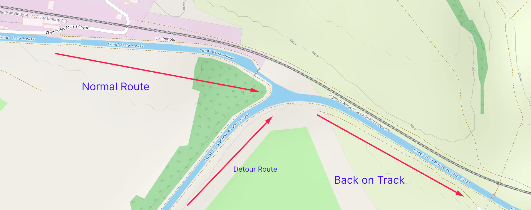
The intersection at Écluse n°1 de Troussey marks an important and rather satisfying moment in the journey: this is where the detour finally comes to an end and the normal route resumes. In other words, if you were required to take the long alternative route, thus adding nearly two extra weeks, around 14 days, to your overall passage, this is the exact point where you rejoin the familiar course once again.
After the (possible extra) distance and time, reaching Pagny-sur-Meuse feels like a return to calmer waters, both literally and figuratively. From here onward, the navigation becomes more straightforward and peaceful. The canal settles into a gentle rhythm, and the surroundings grow increasingly enjoyable, offering a welcome sense of relief after the extended diversion.
From this junction, the route simply continues along the Canal de la Marne au Rhin, gradually leading you onward toward Toul: a particularly pleasant stretch that invites you to slow down and appreciate the scenery rather than hurry through it.
We avoid rushing at this stage. Instead, we will take the time to pause and enjoy a well-earned stop at Pagny-sur-Meuse, a charming and restful place to break the journey before continuing to Toul.
Route Summary
For this last stretch of the Canal de la Marne au Rhin Ouest to reach Toul, the total distance to Toul is approx. 18 km on the Canal de la Marne au Rhin Ouest. But first we will take an extra night of rest at Pagny-sur-Meuse.
The route of today
On this section of the route you will pass the objects:
Upcoming stop: Port de Plaisance de Pagny-sur-Meuse
Nearby Services - Pagny-sur-Meuse
-
Closest Supermarket: Proxi super Pagny
Location: Rue Grande Rue, Pagny-sur-Meuse
Distance: Approx. 400m (5-minute walk from center/canal)
Best for: Daily essentials, fresh bread, and local service. -
Nearest Gas Station: TotalEnergies Access
Location: RD 36D (Relais Porte de Meuse), Pagny-sur-Meuse
Distance: Approx. 1.2 km (15-minute walk)
Service: Daily service (06:00–22:00) with Diesel (Gazole) and Unleaded gas.
Note: Land-based station; easily accessible for fuel cans (jerrycans).
Travel day 10 towards Toul
Day ten: To Toul 🇫🇷
From Pagny-sur-Meuse 🇫🇷 to Toul 🇫🇷
At Pagny-sur-Meuse we will continue on the Canal de la Marne au Rhin, and we will be on the last stretch to Toul. This stretch is about 14 km long. And it has the most locks of any stretch in the route.
At Toul, the marina is right after Ecluse n°25 de Toul on your right hand side. This is where the Parel ends up in episode 23. Only we hope we don't have to stay here longer than expected.
The route of today
On this section of the route you will pass the objects:
Upcoming stop: Port de France at Toul
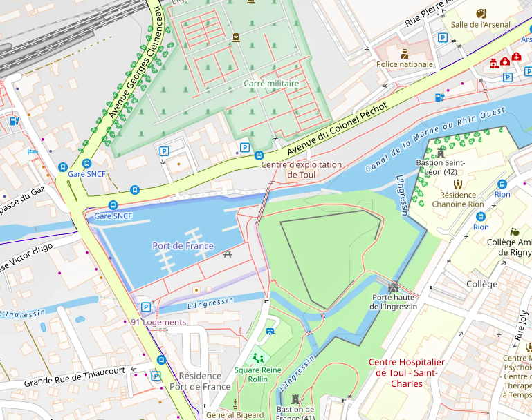
At Toul, the marina is right after Ecluse n°25 de Toul on your right hand side. This is where the Parel ends up in episode 23. Only we hope we don't have to stay here longer than expected. The marina is embedded between Ecluse n°25 and Ecluse n°26 de Toul.
Toul is, just like our hometown Enkhuizen, a city within a wall with bastions. The Bastion Saint Leon is one of those examples. Those bastions where designed to be able to defend the walls under all angles and have shooting sectors that would overlap. And therefore make a better defense system.
The same system you can find in the Netherlands at Bourtange. (Yep, that sounds french too. We to where occupied)
From here: Moselle or towards the Rhine?
From here, we have two options. We can either continue on the Canal de la Marne au Rhin Ouest towards the Moselle, or we can continue on the Canal de la Marne au Rhin Est towards the Rhine. This is an option when you run out of time, or when the route ahead is not navigable. But if you have the time, and if the route ahead is navigable, we recommend to continue on the Canal de la Marne au Rhin Ouest towards the Moselle.
Nearby Services - Port de France (Toul)
-
Closest Supermarket: Auchan Supermarché
Location: Avenue Victor Hugo, Toul
Distance: Approx. 450m (6-minute walk)
Best for: Daily groceries and fresh products within very short walking distance. -
Main Supermarket: Super U et Drive
Location: 250 Avenue du Colonel Pechot, Toul
Distance: Approx. 1.2 km (15-minute walk)
Best for: Large variety of products and extensive stock-ups. -
Nearest Gas Station: TotalEnergies Access
Location: Avenue Victor Hugo / Rue de la République
Distance: Approx. 850m (11-minute walk)
Service: 24/7 automated pumps providing Diesel (Gazole) and Unleaded gas.
Note: Land-based station; accessible for fuel cans (jerrycans).
Getting on the Moselle
At Toul from canal to river 🇫🇷
From Toul 🇫🇷 onto the Moselle 🇫🇷
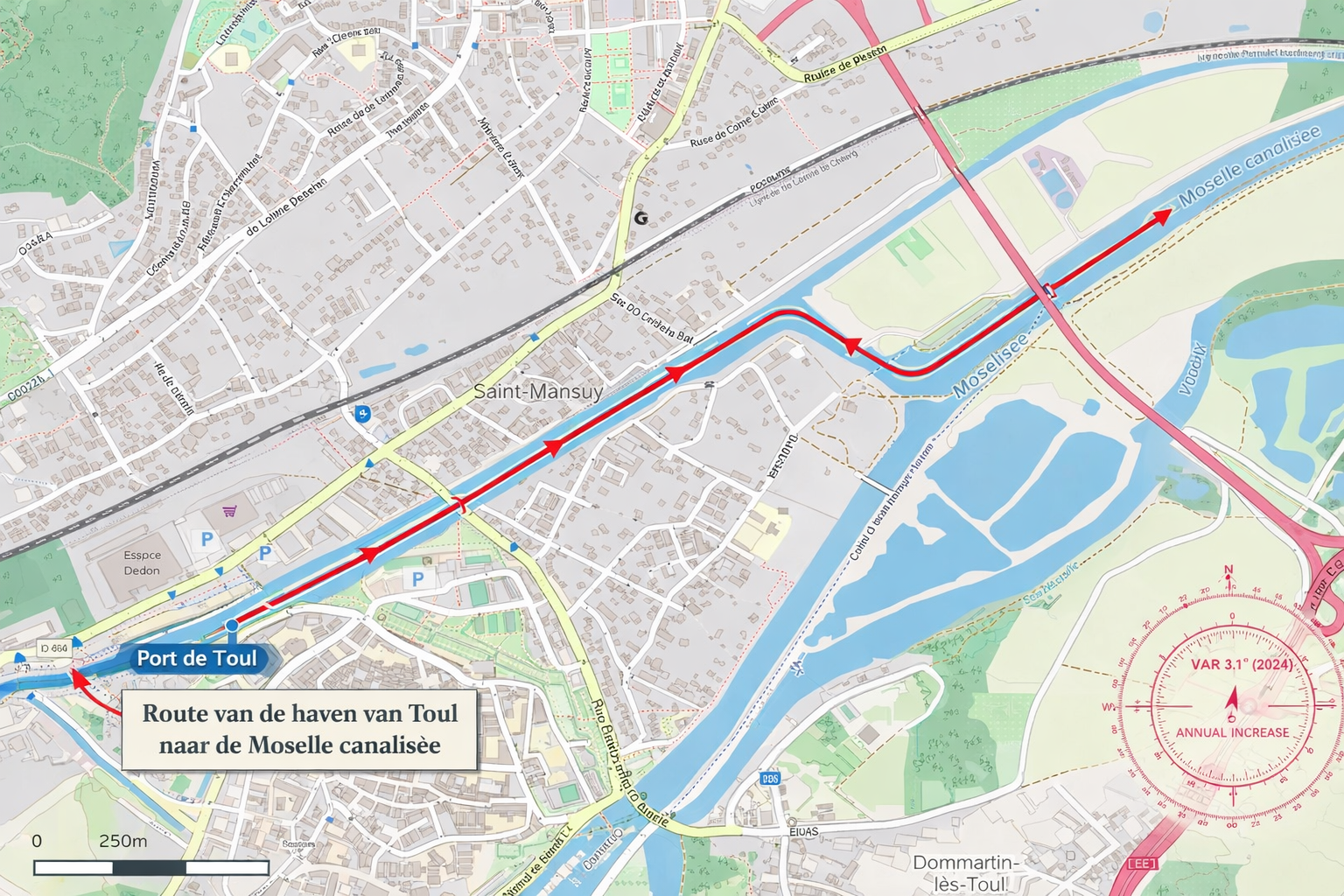
From Toul, we only have to take a short stretch of the the Canal de la Marne au Rhin to end up on the Moselle. At least, onto the Moselle canalisee. This is only a 2 km stretch. But, with 3 locks.....
Important! At the next stop (Pont-a-Mousson) there is no gas station nearby. So make sure you refuel here, or have enough fuel to get to the next availabe stop with a Bunker- or Gasstation.
From Port de France it is only a couple of kilometers until we are on the Moselle river.
Toul as intersection
Toul is one of the intersections between the canals and the rivers. Here you can actually get up the Moselle or down the Moselle, and choose if you want to get to the Rhine at Koblenz, or via Nancy to Strasbourg. All those routes are possible here. Therefore it might a bit confusing when you see some maps, of where you enter and where to go. We hope that this section gives you a bit of information and you can continue the route from here.
What about Saarburg?
You probably noticed that we are diverting a bit from the original route from the Parel by heading to Saarburg. That is because Saarburg has a special meaning to us. It also has a very nice and cozy marina to stay the night (or multiple nights). And after our little side-track on the Saar river, we will return to the Moselle! But it is just the fact that we don't want to miss our apfelstrudel!
From here: Continue in Luxembourg
Travel day 1 towards Saarburg
Day one: From Toul 🇫🇷
From Toul 🇫🇷 onto the Moselle to Pont-a-Mousson 🇫🇷
From Toul, we only have to take a short stretch of the the Canal de la Marne au Rhin to end up on the Moselle. At least, onto the Moselle canalisee. This is only a 2 km stretch from Port de France. But, with 3 locks..... But this might be taking the longest in time during the entire day. After this first stretch of 2 km, we will be on wider and deeper water, with bigger locks with more distance between them. The goal of today is to get to Pont-a-Mousson.
Important! At the next stop (Pont-a-Mousson) there is no gas station nearby. So make sure you refuel here, or have enough fuel to get to the next availabe stop with a Bunker- or Gasstation.
The route of today
On this section of the route you will pass the objects:
Info about Moselle canalisee
The route of today
On this section of the route you will pass the objects:
Upcoming stop: Pont-a-Mousson
Nearby Services - Port de Plaisance Michel Roth (Pont-à-Mousson)
-
Closest Supermarket: Carrefour City
Location: 21 Place Duroc, Pont-à-Mousson
Distance: Approx. 850m (11-minute walk on right bank)
Best for: Quick groceries and fresh bread in the historic center. -
Main Supermarket: Netto
Location: 26 Rue du 26ème Bcp, Pont-à-Mousson
Distance: Approx. 1.2 km (15-minute walk on right bank)
Best for: Full grocery range and daily essentials. -
Note on Fuel: No Gas Station within walking distance
Status: There are no active gas stations within a 30-minute walk (over 2.5 km).
Nearest option: Intermarché or Leclerc (requires a car, bike, or taxi).
Recommendation: Plan your fuel stops accordingly before or after visiting this harbor.
Travel day 2 towards Saarburg
Day two: to Metz 🇫🇷
From Pont-a-Mousson 🇫🇷 to Metz 🇫🇷
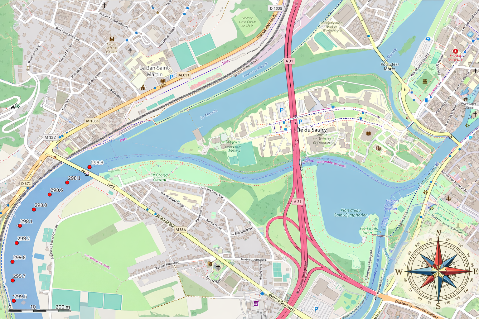
After our visit of Pont-a-Mousson, we continue the trip towards Metz. To get to the marina in Metz, we have to get into a smaller part of the Moselle that has it's own km counter. At KM 299 you already should see the intersection just behind the bridge on your right hand side (it is also on the right bank of the Moselle river).
The marina will be shown at KM 298.8 in the listing, because else it would not appear in the listing.
Important! At the stop at here at Metz there is a gas station nearby. So make sure you refuel here, or have enough fuel to get to the next availabe stop with a Bunker- or Gasstation.
The route of today
On this section of the route you will pass the objects:
Upcoming stop: Quai des regates in Metz. Turn right at km 298,8 and follow the small side-arm of the Moselle, until you reach Plan d'Eau. Keep your route in between the buoys on the north side of Plan d'Eau!
Nearby Services - Port du Quai des Régates (Metz)
-
Closest Supermarket: Carrefour City
Location: 17 Rue des Clercs, Metz
Distance: Approx. 850m (11-minute walk on right bank)
Best for: Quick groceries and fresh bread in the city center. -
Main Supermarket: Monoprix
Location: 31 Rue de la Tête d'Or, Metz
Distance: Approx. 1 km (13-minute walk on right bank)
Best for: Large selection of quality food and extensive daily shopping. -
Nearest Gas Station: TotalEnergies (Relais Metz Kennedy)
Location: 8 Bis Av. Leclerc de Hauteclocque, Metz
Distance: Approx. 1.2 km (15-minute walk on right bank)
Service: 24/7 automated pumps providing Diesel (Gazole) and Unleaded gas.
Note: Land-based station; accessible for fuel cans (jerrycans).
Travel day 3 towards Saarburg
Day three: to Thionville 🇫🇷
From Metz 🇫🇷 to Thionville 🇫🇷
At Metz we go back from Plan d'Eau to the river. From here, we follow the river to the upcoming stop at Thionville. At Thionville center there is a small possibility for mooring at floating docks in the Moselle river.
Important! At the stop here at Thionville there are two gas stations nearby. So make sure you refuel here, or have enough fuel to get to the next availabe stop with a Bunker- or Gasstation.
Also, the walk to get groceries isn't bad either!
The route of today
On this section of the route you will pass the objects:
Upcoming stop: Marina Thionville.
Nearby Services - Halte nautique de Thionville
-
Closest Supermarket: Lidl
Location: 5 Rue de l'Ancienne Gare, Thionville
Distance: Approx. 850m (11-minute walk via the quay)
Best for: Budget groceries and fresh bakery items. Easy access with a trolley. -
City Center Market: Carrefour City
Location: 35 Rue de Luxembourg, Thionville
Distance: Approx. 900m (12-minute walk)
Best for: Quick supplies and essentials in the pedestrian zone. -
Nearest Gas Station: TotalEnergies (Relais de Thionville Metz)
Location: 1 Rte de Metz, Thionville
Distance: Approx. 1.2 km (15-minute walk via the quay)
Service: 24/7 automated pumps providing Diesel (Gazole) and Unleaded gas.
Note: The most direct route for your trolley is following the quay southwards. -
Alternative Gas Station: Esso (Rond Point Merlin)
Location: 2 Rue Stephen Liégeard, Thionville
Distance: Approx. 1.5 km (19-minute walk)
Service: 24/7 automated pumps providing Diesel (Gazole) and Unleaded gas.
Travel day 4 towards Saarburg
Day four: Crossing the border 🇫🇷→🇱🇺/🇩🇪
From Metz 🇫🇷 to Apach 🇫🇷
Thionville served as an excellent final stop before we cross the border toward Luxembourg and Germany. While the transition between these three nations might seem unusual, the natural boundary between Luxembourg and Germany is actually defined by the Moselle River. In this region, where the waterway is locally referred to as the Mosel, the river functions as a shared condominium—a unique arrangement where the entire width of the water belongs to both countries simultaneously.
The route of today
On this section of the route you will pass the objects:
Upcoming stop: Marina Schwebsange. You are crossing the border here at Apach. Please continue in the Luxembourg Section, by clicking on the flag below here.
Important! You are crossing the border and leaving France. Check if your (personal) papers are valid for entering Luxembourg/Germany.
To the Moselle Days IndexWelcome to Luxembourg!
Crossing the border →
Passing Marker 242.2 (LUX)
Which countries will this route pass?
These are the 5 (five) countries we are going to visit. Please use the links to get to the specific chapters (or routes, or legs) of each country.
We added, for good measurement, the ISO Country and the International country-code for calling. There are objects (locks, bridges, etc) that you have to call and do not have any VHF radio. (Or we could not find the VHF information.)
List of Countries
NL - +31
Many canals & rivers (Depending on the chosen route).BE - +32
Mostly Zuid-Willemsvaart, the Albert Canal and the Meuse River.FR - +33
Meuse River, many canals and the Moselle River. Many canals because of the chance of detours.LUX - +352
Moselle River. Shortest stretch.DE - +49
The Moselle, the Saar and the Rhine River.NL - +31
Many canals & rivers (Depending on the chosen route).Of all five countries, we'll only be in Luxembourg for a short stretch: just the section of the Moselle that lies wedged between France, Germany, and Luxembourg. It starts at Écluse d'Apach (FR) and ends at Wasserbillig (LUX), where the Sauer River flows into the Moselle. On this approximately 36 km long stretch, we'll be boating right along the border between Luxembourg and Germany. More about this will follow in the section covering this part of the route.
Support the KNRM!
Help them to help others!

I would like to ask you to become a donor for the KNRM.
The KNRM is a fully private organisation, completely run by volunteers, financed by contributions and donations. You will find all information about them on the website.
You can choose from a single one time payment or a monthly or yearly donation. Please Support them.
Our personal opinion is that every person out on the water should, by law be told to make a donation of €25,- per year. But that is just our opinion.
Copyright, Disclaimer & Attribution
The legal stuff needed because of stupid....
The content on this website may include materials such as text, images, videos, and other media that are the property of their respective owners. All trademarks, logos, and copyrighted works remain the intellectual property of their original creators.
We strive to properly attribute and acknowledge all sources. If you are the copyright owner of any material featured on this site and believe it has been used without appropriate credit or permission, please contact us at [your contact email] so we can promptly address the issue.
Where applicable, the use of third-party content falls under fair use, creative commons licenses, or other applicable legal provisions. If specific attribution is required, it is provided directly alongside the respective material.
The images and data on this site are NOT intended for navigation or critical decision-making. Any reliance on this information is strictly at your own risk. The information on this site is for PERSONAL USE ONLY. You may print or copy parts of it for your own private use. Commercial use is strictly FORBIDDEN. Do not sell, rent, or use this data for profit. Unauthorized commercial exploitation will be met with rigorous legal action to the fullest extent of the law Furthermore, automated data scraping, harvesting, or feeding this content into large language models or AI systems is strictly PROHIBITED. If automated tools crawl this site without express written permission, access will be blocked, and those responsible will be held liable for unauthorized bandwidth usage and intellectual property infringement.
Powered by Haringstad
Build with VIM
© Haringstad, J and S van Koll