Back in NL 🇳🇱
5th Border Crossing →
Entering The Netherlands 🇳🇱 is crossing a border the 5th time
Keep in mind: Depending on how fast the flow of the Rijn is, the speed (SOG) will be increased by that.
By crossing the border, we are back in NL 🇳🇱. Actually, that only depends on where you are between KM 857.7 and KM 865.5. Because in this section, when you are on the left side (left bank) of the river, you are still in Germany. But if you keep the right hand side of the river, you are in The Netherlands. Between those two KM locations, the middle of the river is the border.
So this is where the NL waterways (in)sanity starts! Why? Check your maps and apps. Here is where one single waterway can have multiple names!
The Waterways
Crossing the border also implies: Welcome to the Delta! From here the waterway will split up in several others.
While crossing the border, the Rhein, A.K.A. Boven-Rijn, (KM 862.3) becomes the Bijlandsch Kanaal for 1.9 km. This was dug to bypass a dangerous bend in the River. And connected to that, is the Waal and the Pannerdensch Kanaal, of which the latter is then continuing as the Nederrijn and connects to the IJssel river. Still with us?
Deviation of the Parel route
After crossing the border and using the Pannerdensch Kanaal like the Parel, we are going to deviate from their route and take the IJssel river like the ROBEA did in Episode 34 of the Parel 2024 Boot-Trips. We are going to take the same waterway.
That means from here on, You have to plan your own route home! From here we will follow the Bijlandsch- and Pannerdensch Canal and head on the IJssel. This will carry us all the way to the Ketelmeer, and helps us save some fuel.
Going downstream to our first stop in NL 🇳🇱
Tolkamer 🇳🇱
1st stop after the border
Jachthaven de Bijland (Tolkamer) 🇳🇱
Keep in mind: Depending on how fast the flow of the Rijn is, the speed (SOG) will be increased by that. Always enter a canal or other intersection by moving upstream!
The first Bunkerstation and Marina, is Jachthaven de Bijland (Tolkamer) in NL 🇳🇱. Actually, this is not directly at the river, but in one of the lakes that are created while getting sand and/or gravel. Jachthaven de Bijland is located in one of those. By taking the small canal on the right bank at KM 864.45 you will enter the the lake. First you have the possibility to refuel, and then navigate to the Marina that is on the right hand side of the lake. Please check your navigation!
The canal is a bit narrow, so make sure you stay between the buoys on both sides of the bridge!
From Tolkamer, the route to your home port can be determined. We travel via the Pannerdensch Kanaal and the IJssel, further north. The west can be easily reached via the Waal or the Nederrijn and the Lek. Alternatively, you can head to the northwest via the Pannerdensch Kanaal, the Nederrijn, and the Amsterdam-Rijnkanaal (Zaan, Noord-Hollandsch Kanaal). This last route is the same one De Parel followed to her home port.
All routes you wish to take can be planned using various waterway navigation apps, or you can make use of the ANWB water charts.
We do advise keeping as much as possible with the downstream current to avoid incurring additional fuel costs.
Going downstream entering NL 🇳🇱
The route of today
Today, you will pass the objects:
Nearby Services - Jachthaven de Bijland (Tolkamer)
-
Closest Supermarket: Jumbo Tolkamer
Location: 's-Gravenwaardsedijk 78a, Tolkamer
Distance: Approx. 400m (5-minute walk from the marina entrance)
Best for: Full grocery range, fresh produce, and bakery; incredibly close for heavy provisioning. -
Main Village Shops: Tolkamer Center
Location: Europakade / Tolkamer
Distance: Approx. 800m (10-minute walk)
Best for: Local restaurants, a pharmacy, and specialty shops along the famous quay. -
Note on Fuel: Dedicated Waterside Refueling Station
Status: This location features its own station for pleasure craft within the lake area.
Nearest option: Tankstation de Bijland (located at the entrance of the lake).
Available: Gasoline (Euro 98/E5) and Blue Diesel 20 directly at the jetty.
Recommendation: Perfect for direct refueling. For commercial bunker needs, Bunkerstation Slurink is located nearby on the Rhine (Europakade).
To Doesburg 🇳🇱
2nd stop after the border
Passantenhaven Doesburg 🇳🇱
Keep in mind: Depending on how fast the flow of the IJSSEL is, the speed (SOG) will be increased by that. Always enter a canal or other intersection by moving upstream!
After leaving Tolkamer, we are going to head for the river that might be the one that is having the fastest flow-rate in NL 🇳🇱. The IJssel river is a fast flowing river with from the start to approx. Zutphen, a flow of about 5 km/h. So, your SOG will be actually higher than normal. Longer distances are therefore possible in shorter amounts of time. Just like on this leg.
Here you also will notice the fact that the same waterway might have multiple names within their own context. Like the Pannerdensch- and Bijlandsch Kanaal, who are actually mostly refered to as The Rijn. Actually, the KM counting of the Rijn will just continue in those sections! And that is where the madness starts. But when you just take a good look at your (paper) maps, it will make absolute sense.
About Doesburg
- City Rights: Received in 1237, making it an established power during the rise of the Hanseatic League.
- Trade Specialization: Historically famous for trade in beer, wine, and its world-renowned Doesburg Mustard.
- Architecture: The city features a medieval street pattern and over 150 national monuments.
- "De Waag": Home to the oldest functioning catering establishment in the Netherlands (dating back to 1478), which served as the city's weighing house for trade goods.
The Hanseatic Context
Doesburg is part of the "IJssel Cities" group, which includes other historic trade hubs you might encounter on your route, such as Zutphen, Deventer, and Zwolle. These cities cooperated to protect their merchant interests and dominate trade in Northern Europe during the Middle Ages.
Going downstream towards Doesburg 🇳🇱
On this leg, we are passing a couple of waterways of which some are very short, but still very important:
The route of today
Today, you will pass the objects:
Nearby Services - Passantenhaven / WSV de Oude IJssel (Doesburg)
-
Closest Supermarket: Albert Heijn
Location: Ooipoortstraat 12, Doesburg
Distance: Approx. 450m (6-minute walk from the harbor)
Best for: Quick groceries and fresh bread in the historic city center. -
Main Supermarket Hub: Burgemeester Keiserplein
Location: Burg. Keiserplein, Doesburg (includes **Plus** and **Lidl**)
Distance: Approx. 1.1 km (14-minute walk)
Best for: Full grocery range and a wider variety of discount options. -
Note on Fuel: Nearest Waterside Fuel Station
Status: There is no fuel station directly at the harbor in the city center.
Nearest option: Marina Strandbad (Olburgen).
Distance: Approx. 800m downstream from the Doesburg bridge on the right bank.
Recommendation: For jerrycan refills, there are several road stations within 1.5 km of the town center; otherwise, plan to stop at Marina Strandbad.
To Veessen 🇳🇱
3rd stop after the border
Kozakkenhaven Veessen 🇳🇱
Keep in mind: Depending on how fast the flow of the IJSSEL is, the speed (SOG) will be increased by that. Always enter a canal or other intersection by moving upstream!
That we do not only watch video's of the Parel, shows the episode 34 Over de IJssel en het Zwarte Water | De Canicula. At minute 2.13, you see the Canicula enter the Kozakkenhaven in Veessen 🇳🇱. The episode explains why this little harbor is called the Kozakkenhaven. We are not in a rush, so therefore we make a stop here.
Going downstream towards Veessen 🇳🇱
On this leg, we are continuing on the IJssel:
The route of today
Today, you will pass the objects:
Nearby Services - Kozakkenhaven (Veessen)
-
Closest Grocery Point: Local Bread Point
Location: In the village center of Veessen
Distance: Approx. 250m (3-minute walk from the harbor)
Best for: Daily fresh bread and very basic essentials. -
Main Supermarket Hub: PLUS or Albert Heijn
Location: Heerde center
Distance: Approx. 5.5 km (15-minute bike ride or a short trip via the "buurtbus")
Best for: Full grocery range and extensive provisioning; Heerde offers multiple large supermarkets. -
Note on Fuel: No Waterside Refueling
Status: There is no dedicated marine fuel station in the harbor.
Nearest option: Tamoil Express (Molenweg 1, Heerde).
Distance: Approx. 5 km from the marina.
Recommendation: This is a roadside station; refueling requires a bike, taxi, or car with jerrycans. Plan ahead, as there are no fuel points directly on the IJssel in the immediate vicinity.
To Kampen 🇳🇱
4th stop after the border
W.S.V. De Buitenhaven (Kampen) 🇳🇱
Keep in mind: Depending on how fast the flow of the IJSSEL is, the speed (SOG) will be increased by that. Always enter a canal or other intersection by moving upstream!
We pass Hattem 🇳🇱 & Zwolle 🇳🇱 on our way to Kampen. Both places are very nice to visit too. When you stop at Zwolle, you can moor right at the edge of the city center and Hattem is just very cute. The planning, however, is to stay at Kampen. This old Hanze town with it's cow hanging from the church......
Kampen 🇳🇱 does have a couple of marina's and also a bunker-station! Our planning is to stay at one of the harbors of WSV De Buitenhaven. The two harbors are: The "Buitenhaven" and the "Nieuwe Buitenhaven" which are located next to each other. Our hope is to find a place at the (old) Buitenhaven, although a spot in the Nieuwe Buitenhaven is not so bad either. In between the two harbors, is the wharf of the "Kamper Kogge" and the dutch "Botters".
The route of today
Today, you will pass the objects:
Nearby Services - WSV De Buitenhaven (Kampen)
-
Closest Supermarket: Albert Heijn
Location: Oudestraat 13, Kampen (City Center)
Distance: Approx. 450m (6-minute walk from the harbor)
Best for: Quick groceries and fresh bread in the historic shopping street. -
Main Supermarket Hub: Jumbo & ALDI
Location: Hanzeplein 27, Kampen
Distance: Approx. 900m (11-minute walk)
Best for: Extensive provisioning and a larger selection of discount brands. -
Note on Fuel: Waterside Refueling Station Available
Status: Kampen is a major refueling stop with a dedicated bunker boat/station.
Nearest option: Bunkerstation Slurink (Kampen).
Location: IJsselkade (opposite the city center).
Recommendation: This is a professional bunker station directly on the river. Ideal for larger quantities of Diesel and lubricants without the need for jerrycans. Check current opening hours before arrival.
To Urk 🇳🇱
5th stop after the border
Gemeente Haven Urk 🇳🇱
Keep in mind: Depending on how fast the flow of the IJSSEL is, the speed (SOG) will be increased by that. Always enter a canal or other intersection by moving upstream!
Leaving Kampen 🇳🇱 and heading to wider water. The Ketelmeer. And from the Ketelmeer to Urk 🇳🇱.
Navigating 3 waterways to Urk 🇳🇱
The route of today
Leaving the IJssel onto the Ketelmeer
Navigating Canals and rivers is easier because if you fail, you will crash into the left or right bank. So getting lost is a little harder than on wide and/or open water. From here navigation on wider water will be part of the journey. At least, that is for us! As always, keep a lookout! By leaving the IJssel onto the Ketelmeer, you enter the so called Hanzerak which has a buoy line attached to it:
- Leaving the IJssel at the right bank side with HZR-22 and left bank side HZR-25.
- This is approx. 274° compass course.
- Follow the compass course and bouys line until HZR-18
- Here you have to turn to approx. 287° compass course.
- Continue now on this course along the HZR buoys line to HZR4 - SR1
- Here the new course will be approx. 317° compass course. Obviously, you can already see the Ketelbrug.
- Pass the Ketelbrug and head for a global 325° compass course, parallel to the dyke on starboard side.
This course should get you to the UK-7 buoy and you can actually see the entrance to the harbor from here.
Today, you will pass the objects:
Nearby Services - Gemeentehaven Urk
-
Closest Supermarket: Albert Heijn
Location: Klif 18, Urk
Distance: Approx. 400m (5-minute walk from the harbor)
Best for: Quick groceries and fresh bread in the old village center. -
Main Supermarket Hub: Winkelcentrum Urkerhard
Location: Nagel 42, Urk (includes **Jumbo**, **Lidl**, and **Boni**)
Distance: Approx. 1.5 km (18-minute walk or 5-minute bike ride)
Best for: Full grocery range and a wider variety of shops. -
Note on Fuel: Waterside Bunker Station Available
Status: Urk is a major fishing hub with professional refueling facilities.
Nearest option: Bunkerstation PBE (Urk) or De Flux.
Location: Westkade / Burgemeester J. Schipperkade.
Recommendation: These are professional waterside stations. Ideal for Diesel, GTL, and lubricants directly at the quay. Note that they often prioritize the fishing fleet, so check opening hours (usually closed on Sundays).
To Andijk 🇳🇱
Coming home!
Jachthaven Andijk 🇳🇱
Keep in mind: A boat is as seaworthy as it's crew! Make sure to be safe on the IJsselmeer, when there is some wind!
Leaving Urk 🇳🇱 and heading to Andijk over the IJsselmeer 🇳🇱. This implies that you have to use your navigational equipment, like your GPS, Compass, Callipers. But also your (recent) versions of the 1800 series maps for the IJsselmeer, and possibly your Watermaps app(s).
Leaving the harbor of Urk:
- Follow for about 150 meters 160° compass course until you see red buoy UK 24
- Turn at UK 24 to compass course 188° to get to red buoy UK 22
- Turn at UK 22 to compass course 253° to get to red buoy UK 16
- Turn at UK 16 to compass course 293° to get to red buoy UK 10
- At buoy UK 10 adjust your course to compass course 303° until you see lighthouse De Ven and reach Yellow buoy "Sport D" at GPS: N 52°45'30" - E 5°18'00"
- From Sport D turn to compass course 270° until you reach, or are close at GPS: N 52°45'26" - E 5°11'05"
- From N 52°45'26" - E 5°11'05", turn to compass course 200° that will take you towards the entry of the marina.
Navigating the IJsselmeer 🇳🇱
The route of today
Today, you will pass the objects:
To the Rijn Days Index
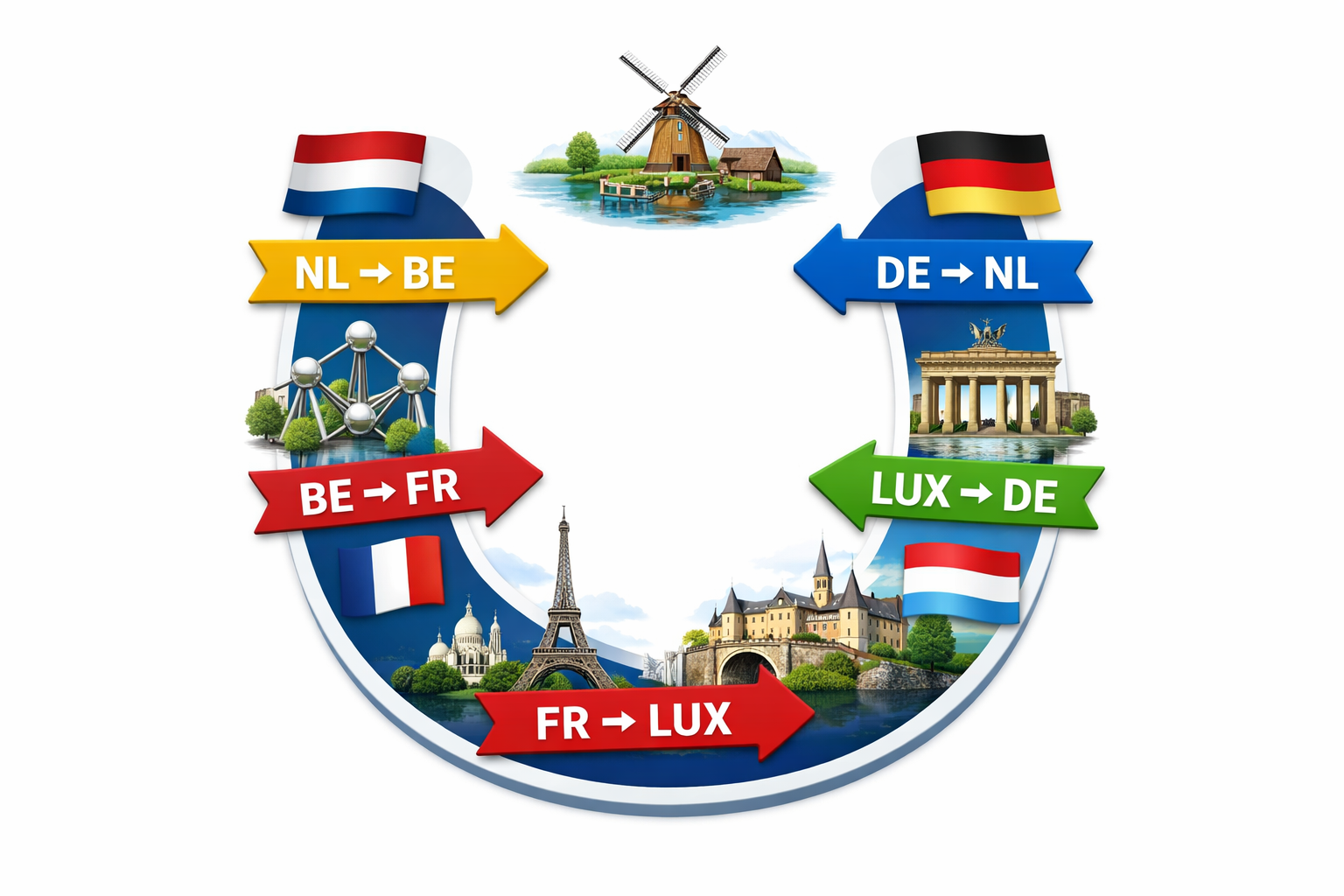
Which countries will this route pass?
These are the 5 (five) countries we are going to visit. Please use the links to get to the specific chapters (or routes, or legs) of each country.
We added, for good measurement, the ISO Country and the International country-code for calling. There are objects (locks, bridges, etc) that you have to call and do not have any VHF radio. (Or we could not find the VHF information.)
List of Countries
NL - +31
Many canals & rivers (Depending on the chosen route).BE - +32
Mostly Zuid-Willemsvaart, the Albert Canal and the Meuse River.FR - +33
Meuse River, many canals and the Moselle River. Many canals because of the chance of detours.LUX - +352
Moselle River. Shortest stretch.DE - +49
The Moselle, the Saar and the Rhine River.NL - +31
Many canals & rivers (Depending on the chosen route).Of all five countries, we'll only be in Luxembourg for a short stretch: just the section of the Moselle that lies wedged between France, Germany, and Luxembourg. It starts at Écluse d'Apach (FR) and ends at Wasserbillig (LUX), where the Sauer River flows into the Moselle. On this approximately 36 km long stretch, we'll be boating right along the border between Luxembourg and Germany. More about this will follow in the section covering this part of the route.
Support the KNRM!
Help them to help others!
I would like to ask you to become a donor for the KNRM.
The KNRM is a fully private organisation, completely run by volunteers, financed by contributions and donations. You will find all information about them on the website.
You can choose from a single one time payment or a monthly or yearly donation. Please Support them.
Our personal opinion is that every person out on the water should, by law be told to make a donation of €25,- per year. But that is just our opinion.
Copyright, Disclaimer & Attribution
The legal stuff needed because of stupid....
The content on this website may include materials such as text, images, videos, and other media that are the property of their respective owners. All trademarks, logos, and copyrighted works remain the intellectual property of their original creators.
We strive to properly attribute and acknowledge all sources. If you are the copyright owner of any material featured on this site and believe it has been used without appropriate credit or permission, please contact us at [your contact email] so we can promptly address the issue.
Where applicable, the use of third-party content falls under fair use, creative commons licenses, or other applicable legal provisions. If specific attribution is required, it is provided directly alongside the respective material.
The images and data on this site are NOT intended for navigation or critical decision-making. Any reliance on this information is strictly at your own risk. The information on this site is for PERSONAL USE ONLY. You may print or copy parts of it for your own private use. Commercial use is strictly FORBIDDEN. Do not sell, rent, or use this data for profit. Unauthorized commercial exploitation will be met with rigorous legal action to the fullest extent of the law Furthermore, automated data scraping, harvesting, or feeding this content into large language models or AI systems is strictly PROHIBITED. If automated tools crawl this site without express written permission, access will be blocked, and those responsible will be held liable for unauthorized bandwidth usage and intellectual property infringement.
Powered by Haringstad
Build with VIM
© Haringstad, J and S van Koll