Welcome to Belgium!
Crossing the border:
The Journey gets interesting →
Where down-to-earth living meets the art of enjoyment.
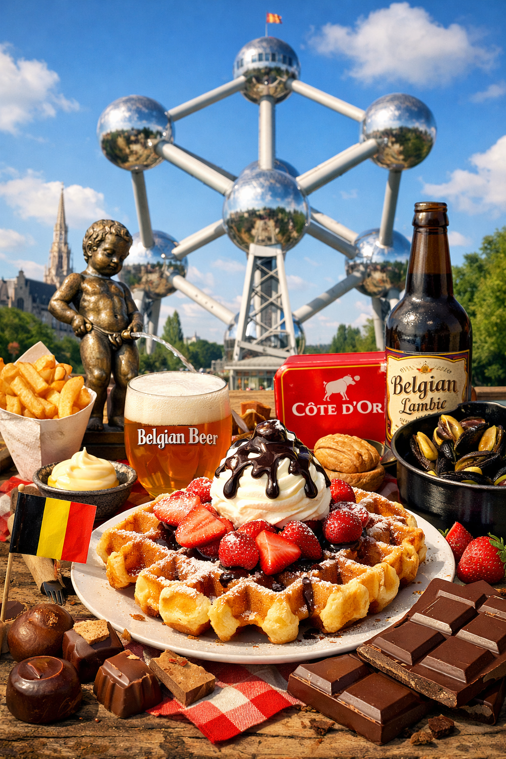
Belgium, the second country along the route, is renowned as the land of chocolate and waffles. It is also one of the five countries where the journey covers a significant number of kilometers.
Entering Belgium at Lozen and leaving the country at Heer-Agimont, the route follows several major inland waterways:
- Zuid-Willemsvaart (Stretch 5 & 6 ZWV)
- Canal Briegden–Neerharen (Stretch 6 ZWV)
- Albert Canal (Stretch 6 ZWV)
- Meuse (Stretch 1 to 4 Wallonia)
Of these, the Zuid-Willemsvaart and the Meuse account for the greatest distances traveled within Belgium.
In addition to planned stops at several locations along the Zuid-Willemsvaart, most overnight stays are scheduled along the Meuse. This section of the route is chosen not only for practical reasons, but also for its scenic value. Along the Meuse, the landscape begins to rise noticeably, introducing the first hills and rocky terrain. The river winds past bastions, castles, and historic citadels, offering a beautiful preview of what lies ahead later in the journey.
Important information
Belgium consists of 2 main parts: Flanders and Wallonia. Both have their own rules and regulations for their waterways. In Flanders you need a paid permit (Waterwegenvergunning) Waterwegenvergunning — the Flemish waterway permit required for vessels longer than 6 metres or capable of exceeding 20 km/h. Valid only for the days spent in Flanders; obtainable online via visuris.be. to navigate the canals and the information about their waterways is very good and openly documented. In Wallonia you only have to "Announce" yourself. And you don't have to pay for a permit. Downside of that is, is that their waterways are not in EuRIS, or other public available sources. Be aware of the differences! It might save you money on fines. You can read more in the Permits section.
Permits and Certificates
You need to bring those in
Permits and certificates you need in Belgium
Permits, Certificates and declarations
ICCInternational Certificate of CompetenceBCMRBasic Certificate Maritime Radio (Operator Certificate)
Radio Licence (Your registration of your Radio including callsign)ICPInternationaal Certificaat PleziervaartuigenPoOProof of Ownership or PurchaseInsuranceInsurance PolicyVATVAT DeclarationWaterways PermitWaterways Permit (Waterwegenvergunning).
You do need for the Flanders section of Belgium a Waterways Permit (Waterwegenvergunning) when your boat is longer than 6 meters and/or can go faster than 20 km/h. This permit is needed on Flemish inland waterways (Vlaanderen).SPW NumberSPW Number.
You do need for the Wallonian section of Belgium a number that will be for your boat when your boat is longer than 6 meters and/or can go faster than 20 km/h. You have to get this at the first possible entrance of Wallonia. More information you can find in this document (French/Dutch)
Waterwegenvergunning in Flanders
For the Waterways Permit (Waterwegenvergunning) you don't have to pay for the entire time you spend in Belgium. You only have to pay for the time you are in Flanders. This implies that you only have to have a permit for the part where you Enter Belgium, and when you enter Wallonia (Safely: Luik - Liege). Whenever you are In Wallonia (e.g. the Meuse) you don't need the Waterwegenvergunning.
You can obtain a permit online by visiting: https://www.visuris.be/waterwegenvergunning. As stated in the pdf, you will find here instruction video's.
Be aware! The Marina at Kanne is still Flanders! So when you choose to stay there overnight, you have to count those days too!
How to announce yourself in Wallonia to get your SPW number
In Wallonia you should, at the first "object" (bridge, lock) announce yourself, by Marine radio, Telephone or in Person. You do get a SPW number.
At every "object" you then can use your SPW number (or your vessel name) to tell them where you are heading to. Here you have an example text you can use:
Bonjour,
Je souhaite annoncer la navigation d'un bateau de plaisance.
- Nom du bateau : Tom
- Marque et type : Viksund Columbi 27
- Longueur : 8,05 mètres
- Largeur : 2,85 mètres
- Tirant d'eau : 1,05 mètre
- Hauteur : 2,40 mètres
- Numéro de série : aucun
- Motorisation : moteur diesel Volvo Penta MD2B, 25 chevaux
Nous sommes entrés par Lozen et nous naviguons en direction de Heer-Agimont.
Nous ne savons pas encore où nous nous arrêterons.
L'arrêt dépendra de la météo et des possibilités touristiques rencontrées en route.
Merci de votre aide.
Write down the number they give you. At the next object you only have to give them that number.
The Zuid-Willemsvaart in Belgium
Stretch 5 in Flanders
A Dutch 🇳🇱 canal in Belgium 🇧🇪?
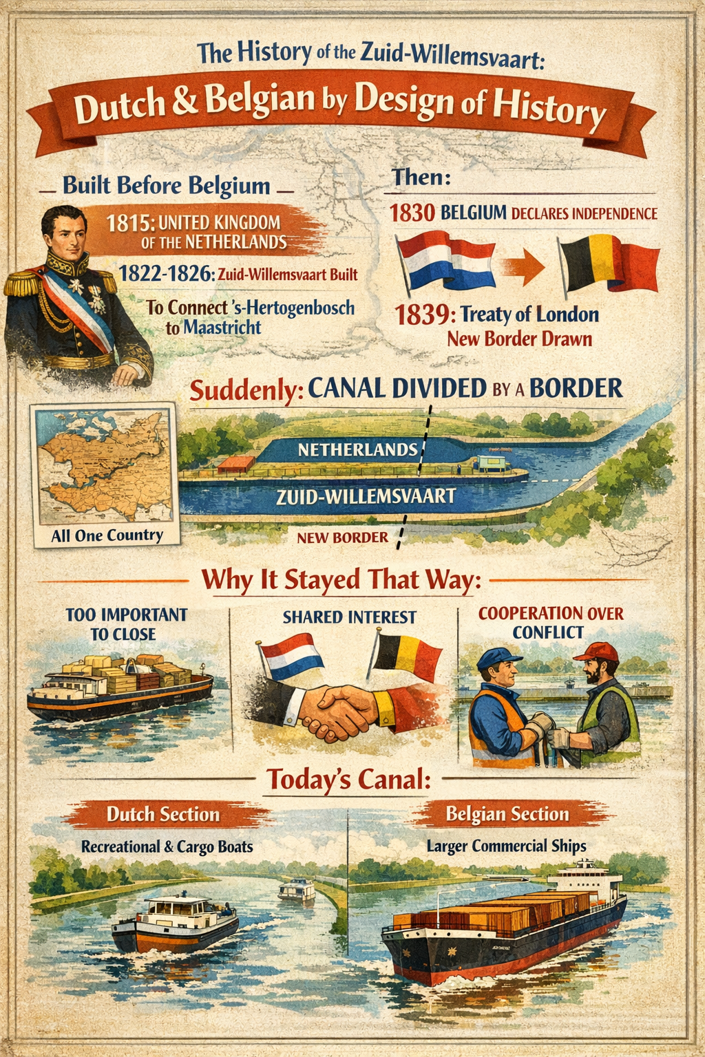
Yes. And we are going to do the following stretch on this canal! The Zuid-Willemsvaart is partly Dutch and partly Belgian because:
- it was built before Belgium existed
- borders changed, canals didn't
- both countries chose cooperation over fragmentation
The independance of Belgium made that a Dutch 🇳🇱 canal now became Belgian 🇧🇪. Over time, both countries upgraded "their" sections differently:
- The Belgian part was modernised earlier for larger commercial vessels.
- The Dutch part kept a more mixed character, serving both commercial shipping and later recreational boating.
Today, you can still see the differences in:
- lock sizes (*)
- bank construction
- surrounding industrial development
(*) Hence why the 63 meter long cargo ship Vito was stuck from 5 November 2025 up to the end of January 2026 the "City Bridge" at Weert, due to the fact that the locks on the Dutch side where not large enough to bring the Vito out of it's tight spot.
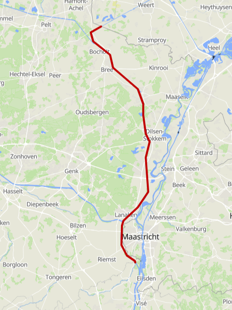
From Weert 🇳🇱 to Kanne 🇧🇪?
Stretch 5 in Flanders
Can you do this in one single day?
It is possible to navigate from Weert 🇳🇱 to Kanne 🇧🇪 in one single trip!
Route from Weert 🇳🇱 to Kanne 🇧🇪
LengthApprox. 55 KmTravel TimeEstimated 8,5 hoursObjects36 Bridges, 4 Locks
From the border to Bocholt
Stretch 5 in Flanders
From the border to the first intersection
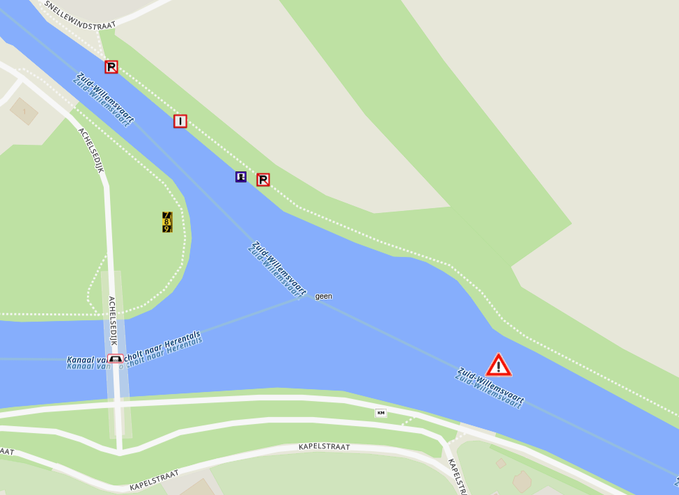
After crossing the border from The Netherlands into Belgium, at N 51°12.992', E 5°34.996', the route continues on the Belgian section of the Zuid-Willemsvaart until we are getting to the first fork. This fork is connecting one of the Flemish inland waterways (Vlaanderen): Canal from Bocholt to Herenthals that takes you eventually to Antwerp.
The Fork is at KM 42 and connects to Canal from Bocholt to Herentals. The Canal from Bocholt to Herentals is on the starboard side and goes towards the west.
This implies that this canal might be used by commercial vessels to get to, or from Antwerp. So, be aware of vessels that might be faster.
On this stretch of the Zuid-Willemsvaart from the Border to the intersection with the Canal from Bocholt to Herentals you will pass some objects:
From the intersection to Bocholt
So, taking a turn to starboard is not the route as planned and therefore continue straight on the ZWV.
From the intersection it is only a very short stretch to the marina at Bocholt.
On this stretch of the Zuid-Willemsvaart the Intersection to Bocholt, you will pass some objects:
Bocholt: Possible supply stop
At Bocholt there is a small visitors marina, that seems to be very neatly kept and is not expensive.
At Bocholt, the grocery-shop is just a 5 minute walk. And due to the fact that they have nice facilities, a resupply stop here, might be an idea. If not? Then just continue from here to Kanne!
Bocholt to Kanne
Stretch 6 ZWV in Flanders
A Longer stretch on the ZWV
This section of the ZWV will end at Neerharen, where the Canal Briegden–Neerharen will be entered. And at the end of that Canal, the Albertcanal will be entered. And on that Canal the marina of Kanne is situated.
Along this stretch, there are some interesting locations that you can make a (short) stop. Like the outlet centre Maasmechelen Village (51.00016, 5.71008) where nice mooring places are. The walk only takes about 10 minutes from the quay. But also the other (small) marinas along the way, or even the smaller mooring spots can give you a point to rest, or enjoy the views.
Be Aware! Keep in mind the expiration date of your Waterwegenvergunning! Extend the time period if you choose to stay longer. And don't be surprised when this will be checked during your stay in Flanders. As already mentioned before, for Wallonia you don't have to pay, but you have to announce yourself at the first "object" that provides entry to Wallonia.
The last stretch on the Zuid-Willemsvaart
From Bocholt it takes almost 40 kilometres to Neerharen. Along this stretch there are no locks and the route is pretty straight forward.
On this stretch of the Zuid-Willemsvaart from Bocholt to Neerharen, you will pass some objects:
The fork at Neerharen
Stretch 6 ZWV in Flanders
Fork Zuid-Willemsvaart - Canal Briegden - Neerharen
After the bridge "Neerharen", there is the next fork.
At this fork there are the following canals:
Fork at Neerharen
Straight (South)Enter Canal Briegden - Neerharen
Leads to the Albertkanaal and towards Kanne. The preferred route.Port (East)Continue on ZWV and go towards Maastricht.
Nice for a stop, but also involves the Ternaaijen Locks that go up 14 meters(!) to get on the Albertkanaal. Check your maps/apps if you want to visit.The preferred route is straight: entering the Canal Briegden - Neerharen. This canal is connected to the Albertcanal.
Canal Briegden - Neerharen
This is not a very long stretch of waterway. It is only 4.5 km long. And the fact that there are two locks on this stretch, makes it a bit more time consuming. But the good news is that there are no bridges that have to open on this stretch, so you don't have to worry about that!
On this the Canal Briegden–Neerharen, you will pass some objects:
Connection Canal Briegden - Neerharen and the Albertcanal
Now the connection with the Albertcanal is approaching. Navigation is actually simple: Go straight and "cross" the Albert Canal to get to the starboard side of the canal. Be aware that there are also cargo ships passing here!
Fork at Briegden
Straight (South)Enter the Albert Canal
Leads towards Kanne and the Meuse river at Liege (Luik).The preferred route.Starboard (West)Take the Albert Canal towards Antwerp..
If you want to take a different route from here, go starboard.Almost on the Meuse River! We are going to follow the Albert Canal from here, heading south.
The Albert Canal
Stretch 6 in Flanders
The Flemish part of the Albertcanal
Maximum Speed: 15 KM/H
This Canal is one of the (political) accomplishments of Belgium. They dug the canal to avoid being dependent on The Netherlands to get to Antwerp, or even Rotterdam. They wanted their own canal and that became the Albert Canal. King Albert ordered the canal, but not lived to see the opening.
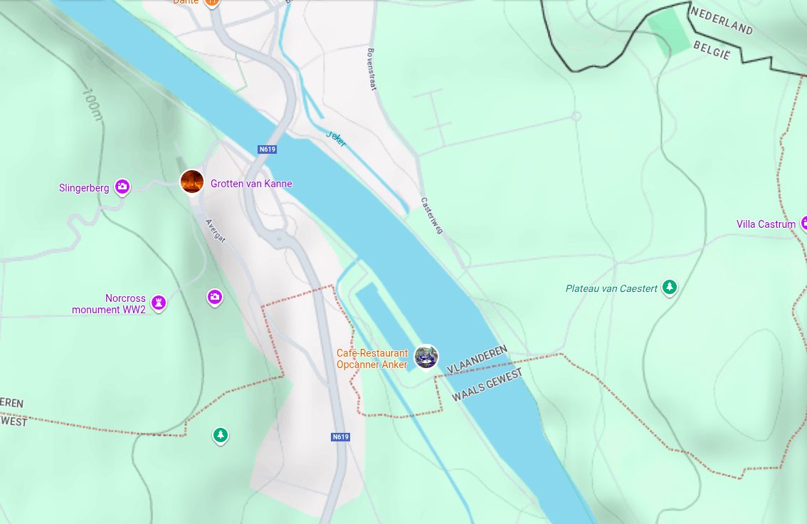
Following the Canal, at a certain moment, the marina "Kanne" will appear on the starboard side. As seen in the vlog of The Parel, this is a very nice marina. Also close to the caves of Kanne and Fortress Eben-Emael.
Be Aware! In the marina of Kanne, you still need your Waterwegenvergunning! The Marina is still in Flanders!
On the Albertkanaal, you will pass some objects:
To visit in Kanne
The town of Kanne is a small but charming town in Flanders, Belgium. It is known for its beautiful location along the Albert Canal and its historic center. The town offers a peaceful atmosphere and is a great place to stop and explore.
There are the caves of Kanne, which are a popular attraction in the area. And the fortress Eben-Emael, which is a large fortress built in the 1930s to defend against potential invasions. The fortress is now open to the public and offers guided tours that provide insight into its history and significance.
Welcome to Wallonia!
Stretch 1 in Wallonia
From Kanne to Tihange
By leaving the marina at Kanne, globally heading South-East on the Albert Canal, we cross the (language) border of Flanders and Wallonia. Here you have to "announce" yourself to get your SPW Number.
You can do this by stopping at Lock Ternaaijen (Lanaye) and bring your paperwork and request a SPW number there. When you are dutch, this might be the best option, due to the fact that they do speak dutch at this lock. This makes it easier to communicate.
Because, not only the rules change here, but also the language. French is the official language of Wallonia and Flemmish (very similair to Dutch) is spoken in Flanders. This "language barrier" provides some stress because not everyone is fluent in French......
Now things are about to get exciting, because my command of the French language is roughly equivalent to the surface area of a pinhead. In other words, nonexistent. Absolutely nothing. Zero. Which means I will have to listen very carefully, with an intensity usually reserved for bomb disposal, and make a truly heroic, borderline tragic effort to understand even the simplest sounds coming my way. (And this might be my struggle until Wasserbillig (DE)). So lets get on our way!
Be Aware. From here on, there is NO EuRis information available regarding the Meuse!
We will do our best to use freely available information for the objects along the route to the French border.
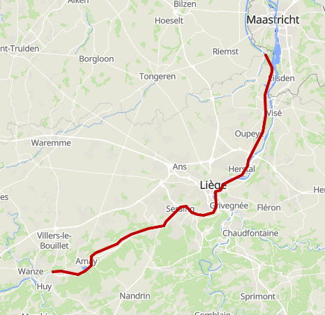
This stretch takes us from Kanne to Tihange, near Huy.
In Tihange there is a very nice marina,The Royal Yacht Club Huy, which is covered in episode 4 of the Parel Boot-Trips 2024. So let's go!
Last stretch of the Albertkanaal
From Kanne, there is the last stretch of Albertkanaal before we end up on the Meuse River. All objects on this stretch of the Albertkanaal are, to our surprise, unavailable trough EuRis.
On the Albertkanaal heading to the Meuse🇧🇪, you will pass some objects:
Leaving The (King) Albertcanal
Technically you are already in Wallonia when you passed the entrance of the marina in Kanne. The border between Flanders and Wallonia is just South-East of the entrance to this marina. But from here on it is truly safe to say that you don't need the Waterwegenvergunning you need in Flanders!
Don't forget!
To announce yourself to get an SPW number!
Just make sure you do this as fast as possible.
You are leaving the Albertkanaal, when you see the statue of King Albert on your port side, where he is looking upstream towards Liege (Luik). And you are now....
Entering The Meuse!
Stretch 1 in Wallonia
First some important (boring) information!
Information regarding the Wallonian part of the Meuse river is very hard to find. We did our best to gather as much information as possible. It might seem a little "chaotic" at first glance, but bear with us. You might be surprised!
Upstream on the Meuse river!
From here, the route will be going "upstream" (opvaart). The advantage of doing the route this way, is that the Meuse is a "Rain River". Also the Meuse is "canalized" by putting in a lot of Locks. Next to the locks are the "water overruns", or "waterfalls" that keep the waterlevels at a certain hight. Lots of rain? Lots of Water and current. Nice weather? Not too much water and current. The waterfalls are, with strong currents, pretty powerful, so be very much aware of where you are, and what you are doing! On the other hand if it hasn't been raining a lot, the current against is not so bad. You should, more or less expect a current against of about 1 - 2 KM/h during normal weather. This will increase when it rains, or right after it has been raining. Keep in mind that rain Upstream of the river, has effect on you, more downstream on the river. Rain around Namur or higher up the river, takes some time, to reach you in Luik.
Why is there no RIS information about the Meuse?
The Wallonian government decided that the Meuse river does not have significant meaning to commercial shipping. Therefore they do not put any information into their RIS system, and therefore EuRis does not have any information regarding objects on the Meuse river, globally from Heer-Agimont to north of Liege (Luik).
Wallonia and RIS information
There is hardly any information regarding the Wallonian part of the Meuse river in RIS or EuRis. It seems that the river Meuse isn't of any (commercial) interest to "invest" in RIS information. It makes it a little harder to find information, but we do our best to give you all the info you need. But there is also a positive side to this: You don't have to pay for your registration.
The route will take us further through Wallonia, from globally Liege (Luik), to Givet in France. So lets first list some important facts about the Meuse.
The Belgian part of the Meuse
Max Speed15 km/hLocks13Bridges37Min. Clearance5 meterMarina's11 (7 ports + 4 relais)Gas StationsInformation Site
Heading for Liege (Luik)
On port side (Right side of the Canal, Left Side of the River), you did see the statue of King Albert, who ordered the dig of the Canal. And yes, right before this fork, you could have gotten Diesel, other fuels, oils, and other things you might need.
At almost any lock you can get Drinkwater at those Locations
Now going upstream on a river. And that has implications. Like looking even further forward and behind you. Due to the fact that your SOG will be (way) slower than the SOG of cargo ships, they can sneak up on our back. Therefore, looking backwards and watching AIS (if you have that) will help And increase your security.
When you own Marine Radio(s), make sure to listen to the proper channels and be not afraid to communicate. Cargo will be happy when you make sure they understand your intentions.
So, lets continue to Tihange!
At Meuse KM 113.5 we exit the Albertkanaal and Enter the Meuse. You might feel already the current of the river push and from here, this will be the case until deep in France.
On the Meuse, you will pass some objects:
Around Port de plaisance de Corphalie
There are a couple of nice restaurants around Port de plaisance de Corphalie. There is not too much to do around the port, but you can have a nice walk along the river, and enjoy the view.
Tihange to Namur
Stretch 2 in Wallonia
The Next stretch in Wallonia
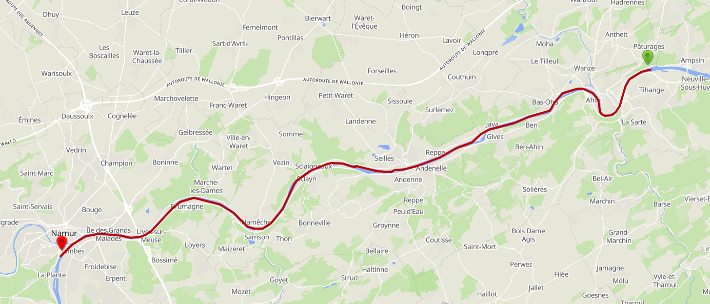
Leaving Port de Corphalie, we also might say goodbye to Restaurant Les Chats qui Rient Huy that does have 5 stars on Google..... So we leave Tihange and are on our way towards Namur.
The following stretch will end in Namur (Namen). And yes, we do follow globally the stops of the Parel. Why? Because of the beautiful places that they show us and are worth visiting, like the Citadel and the medieval city.
Namur is the gateway to the Ardennes. Where the Samber is connecting to the Meuse, it is the official starting point where the landscape becomes noticeably more rugged
On the Meuse, you will pass some objects:
Namur - Dinant
Stretch 3 in Wallonia
The third stretch in Wallonia
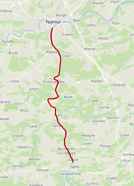
The following stretch will end in Dinant. And yes, we do follow globally the stops of the Parel. Why? Because of the beautiful places that they show us and are worth visiting.
Leaving Marina de Namur, look up to the Citadel and remember the nice stay. It might now sink in that we are now between mountains. At least, with the Citadel being at 190 metres, it starts to look like that. (Others might say they are just hills, which technically is correct. But for us Dutch, anything like an molehill is already a "hill" so these are mountains to us.)
Île de Dave is an island in the Meuse river, upstream towards Dinant at about the town of Dave. Instead of "civilizing" this island, the Belgian government decided to leave it to nature after WW2. It is the biggest island in Belgium! Now it is a refuge for even turtles(!)
One of the things we want to look at is the Citadel of Dinant. And there are certainly some nice restaurants in the city. So we will have a nice walk trough the city, and enjoy the view. Or visit some nice locations:
- Collegiate Church of Our Lady (Collégiale Notre-Dame): A magnificent 13th-century Gothic church with an iconic onion-shaped dome. Inside, you can admire one of the largest stained-glass windows in Europe.
- Freÿr Castle (Château de Freÿr): Located 6 km from the town centre, this Renaissance castle is famous for its vast gardens in the style of Versailles and its centuries-old orange trees.
- La Merveilleuse Cave (Grotte La Merveilleuse): This stalactite cave, discovered in 1904, is considered one of the most beautiful in Belgium and is within walking distance of the town centre.
Also: Dinant is Located in the heart of the Ardennes, known for its characteristic rock faces along the river.
On the Meuse, you will pass some objects:
Dinant - Heer-Agimont
Stretch 4 in Wallonia
The fourth and last stretch in Wallonia
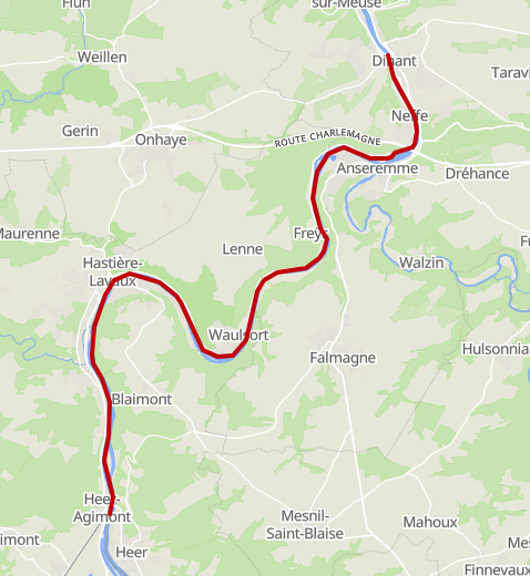
The following stretch will take us across the border into France. Leaving Belgium and entering France with the first tunnel ahead.
Leaving the beautiful city of Dinant. From here, we are going to navigate the last stretch of the Belgian Meuse.
This part takes us from Dinant to Heer-Agimont, where we will cross the border into France. At Heer-Agimont, at the last bridge before entering France, is the last place where you can refuel in Belgium.
There is a Q8 Gas station, 200 meters from the bridge, on the left bank of the river (your right hand side.) On Google it states that they are open 24/7, so we suspect that there is a pay-terminal outside. At the bridge you can moor pretty decent, as far as we can see from pictures and google. And the prices here might be way lower than in The Netherlands!
On the Meuse, you will pass some objects:
Welcome to France!
Crossing the border →
Passing Marker 0.0 (BE)
Which countries will this route pass?
These are the 5 (five) countries we are going to visit. Please use the links to get to the specific chapters (or routes, or legs) of each country.
We added, for good measurement, the ISO Country and the International country-code for calling. There are objects (locks, bridges, etc) that you have to call and do not have any VHF radio. (Or we could not find the VHF information.)
List of Countries
NL - +31
Many canals & rivers (Depending on the chosen route).BE - +32
Mostly Zuid-Willemsvaart, the Albert Canal and the Meuse River.FR - +33
Meuse River, many canals and the Moselle River. Many canals because of the chance of detours.LUX - +352
Moselle River. Shortest stretch.DE - +49
The Moselle, the Saar and the Rhine River.NL - +31
Many canals & rivers (Depending on the chosen route).Of all five countries, we'll only be in Luxembourg for a short stretch: just the section of the Moselle that lies wedged between France, Germany, and Luxembourg. It starts at Écluse d'Apach (FR) and ends at Wasserbillig (LUX), where the Sauer River flows into the Moselle. On this approximately 36 km long stretch, we'll be boating right along the border between Luxembourg and Germany. More about this will follow in the section covering this part of the route.
Support the KNRM!
Help them to help others!
I would like to ask you to become a donor for the KNRM.
The KNRM is a fully private organisation, completely run by volunteers, financed by contributions and donations. You will find all information about them on the website.
You can choose from a single one time payment or a monthly or yearly donation. Please Support them.
Our personal opinion is that every person out on the water should, by law be told to make a donation of €25,- per year. But that is just our opinion.
Copyright, Disclaimer & Attribution
The legal stuff needed because of stupid....
The content on this website may include materials such as text, images, videos, and other media that are the property of their respective owners. All trademarks, logos, and copyrighted works remain the intellectual property of their original creators.
We strive to properly attribute and acknowledge all sources. If you are the copyright owner of any material featured on this site and believe it has been used without appropriate credit or permission, please contact us at [your contact email] so we can promptly address the issue.
Where applicable, the use of third-party content falls under fair use, creative commons licenses, or other applicable legal provisions. If specific attribution is required, it is provided directly alongside the respective material.
The images and data on this site are NOT intended for navigation or critical decision-making. Any reliance on this information is strictly at your own risk. The information on this site is for PERSONAL USE ONLY. You may print or copy parts of it for your own private use. Commercial use is strictly FORBIDDEN. Do not sell, rent, or use this data for profit. Unauthorized commercial exploitation will be met with rigorous legal action to the fullest extent of the law Furthermore, automated data scraping, harvesting, or feeding this content into large language models or AI systems is strictly PROHIBITED. If automated tools crawl this site without express written permission, access will be blocked, and those responsible will be held liable for unauthorized bandwidth usage and intellectual property infringement.
Powered by Haringstad
Build with VIM
© Haringstad, J and S van Koll