Navigation is most of the time the biggest issue that is causing problems for alot
of people on the water. There are so many things to consider: Compass, Charts & Maps,
Tidal Tables, GPS, AIS, and many, many more things.
Caution! Only use this information to educate yourself.
The information on this page about navigation without equipment is purely informational!
We are not responsible for any damages when you use the mentioned info as your main
and only means of navigation!
Buoys are most of the time a confusing issue for alot of people.
They also use different systems around the world!
We try to make things a bit easier for you here.
And there are some old European sayings that might help you!
Systems used
SIGNI: Europe Inland Waterways
IALA Zone A: for Europe, Africa, Asia, Australia
IALA Zone B: for North & South America, Japan, Korea
The systems are different for inland waters and for open water.
Within European inland waters, the SIGNI system is used.
At sea, the IALA system is used.
For Europe, Africa, Asia and Australia (Zone A) the IALA
and SIGNI system use the same rule as the SIGNI system:
Looking down stream (towards sea), than:
Green is LEFT when sailing out to sea
Red is RIGHT when sailing out to sea
And that is the opposite when coming from sea. Therefore the following sayings are "true":
When Fishermen had their Green light on the side of the Red buoys,
that meant they are heading towards sea. (Red as the color of the blood that flows
out of a broken heart.) But when they come home and have "Green on Green"
this implies that they come home. You actually are going Upstream.
(You can see here how that looks like on your boat).
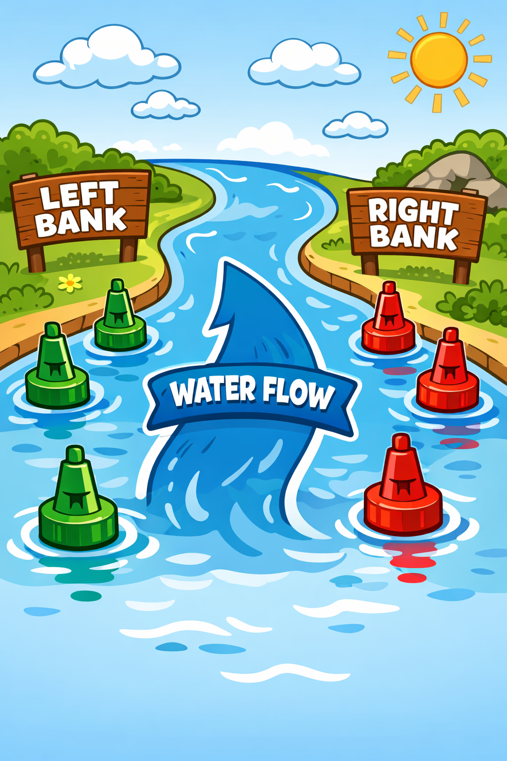
What is the "left", or "right" bank?
The most confusing part is, what is the left side bank, and what is
the right side bank of a waterway. Lets start with explaining it with
a river: (Fig.1 Signi Left/Right)
You always look "towards sea" or "downstream"
and then the buoys are:
Left bank = Green = Uneven numbers (1,3,5,7)
Right bank = Red = Even numbers (2,4,6,8)
And now I will explain where most people go "wrong" in their head. People are told from
being a child, that anything on your left hand side, is "left" and anything on your right hand
side is "right". This is pretty normal when you are driving. But with boating it is a bit different.
But I guess I can make it more clear to Europeans:
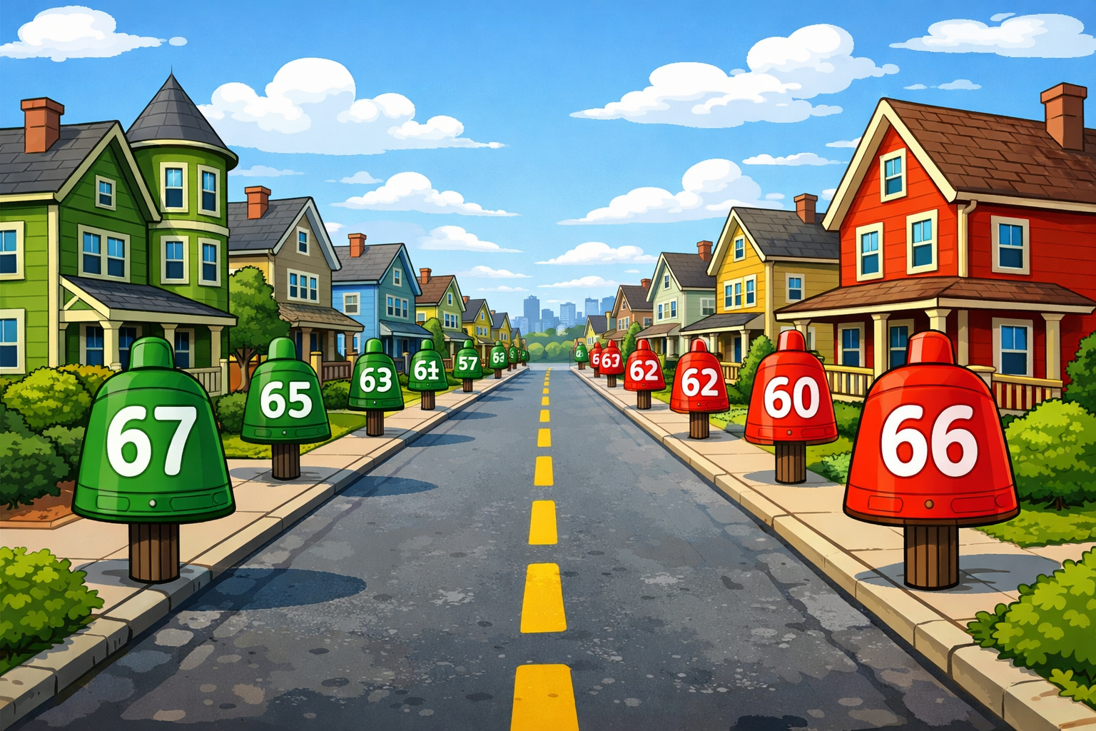
Consider yourself in a regular street in a city or town. Both sides of the street have houses.
And all houses are numbered and you have two sides to this street:
The side of the street with the EVEN numbers
The side of the street with the UNEVEN numbers
Fig.2 - Even/Uneven street
It truly does not matter from which side you enter this street, because the houses
with the even numbers will always on the same side of the street, just like the uneven
numbers will always be on the same side of the street.
So lets assume you are driving into the street and the numbering starts at #1 at YOUR
right hand side. (Green Buoy #1). And automatically you know that #2 will be on YOUR
left hand side. (Red Buoy #2). You are now actually coming from sea, and going up the river, heading
home.
Now, you turn into the street from the "high" numbers. Now you see that the even numbers
are now on YOUR right hand side (Red Buoy #66), and the uneven numbers are now on
YOUR left hand side. (Green Buoy #67)
In both cases, nothing changed to the houses or the numbering.
You still have the EVEN (RED) and UNEVEN(GREEN) numbering on their designated
side of the street. That did not change at all. Only you changed direction!
Another help might be: Right uses the same letter to start as Red.
Caution! this is only for buoys, NOT for your navigation lights!!!!!!!!
The moment that you enter zone B (North & South America, Japan, Korea) it is exactly the opposite. And
they use the system also for INLAND waterways in North-America!
We can also state that the European SIGNI system is flawlessly migrating into our Zone A IALA system.
We do hope that this takes away a bit of the confusion! More information below the table with buoys.
SIGNI System
Left side (CONICAL)
Right side (CAN)
Description
Fairway marking (main buoyage line).
Recreational buoyage: usable water outside the main buoyage.
Boundary of a special area; marking for through traffic.
Stake marks; also called posts/stakes/brush marks.
Tied together: same meaning as a green buoy (LEFT SIDE).
Branches sticking out: same meaning as a red buoy (RIGHT SIDE).
Perch mark: dangerous point or obstacle, groyne, object in the water, etc.
Separation buoy: main channel on the left. This buoy lies in the red (CAN) buoy line and, when going downstream (towards sea),
should be kept to starboard (right) of the vessel.
Separation buoy: main channel on the right. This buoy lies in the green (CONICAL) buoy line and, when going downstream (towards sea),
should be kept to port (left) of the vessel.
Separation buoy: channels of equal importance. (Spherical topmark. Also called a “mid‑channel buoy”.)
Navigation on inland waters
Fig.3 - SIGNI up river
To navigate rivers, canals and lakes safely, signalling is used according to the SIGNI system
(Signalisation des voies de Navigation Intérieure). This applies to European inland waters.
Due to the fact that the SIGNI and IALA Zone A follow the same rules, the Scheldt, Waddensea, and Ems-Dollard
will have the same structures. The buoyage/signage is divided into lateral marks and cardinal marks.
Lateral marks indicate the sideways limits of a fairway.
Cardinal marks are used on larger waters to indicate dangerous points.
Lateral marks
To make the course of a fairway visible, marks are placed along its edge at regular intervals.
When marking the navigable part, the terms left bank and right bank are used.
Determine them with your back to the higher side (where the water comes from) looking toward the lower side (downstream, where the water goes).
For canals this is also from high to low, i.e., towards the lower level.
For other waters, the following rules are agreed:
Tidal area: looking in the direction of the ebb stream (i.e., “towards” the sea).
Side channels and gullies: looking in the direction of where the main fairway is.
Lakes: in the direction of the outlet to open water.
Randmeren (border lakes): looking from Amsterdam.
Rivers: looking down stream/down hill, e.g towards the sea (Fig.1).
The buoyage used can be recognised by shape and colour. See the table earlier on this page.
To be clear, when you are going downstream, that is how you determine the left and right bank
of the river (or canal). So, you stand on top of the mountain, looking down towards how the water
flows (Fig.1), the left hand side is the left bank. The right hand side is the right bank. And this
does not change when you go upstream.
The left side is conical or has a conical topmark and is primarily green.
The right side is can‑shaped (cylindrical) or has a can topmark and is primarily red.
Junctions are indicated by spherical buoys with a combination of both colours.
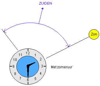
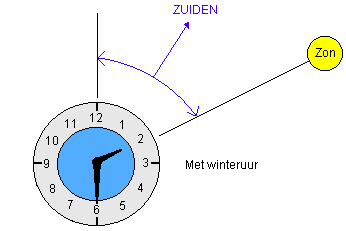
If the sun is visible, you can find north by pointing the hour hand of an analogue watch
at the sun. The imaginary line that bisects the angle between the hour hand and the
12 o’clock position indicates the north–south line within a few degrees.
In the northern hemisphere, the extension of this bisector points south; north is 180
degrees the other way, behind the observer. Do not forget to account for daylight saving
time (subtract that extra hour first).
When it is overcast, you can sometimes still apply the same idea by placing a knife with
the tip of the blade on your thumbnail. The blade casts a faint shadow that changes width
as you rotate the knife. When the shadow is thinnest (or disappears), the flat of the blade
is aligned with the sun. Keep the watch’s hour hand parallel to the blade and determine the
north–south line as described above. Use this method with care: if the sun is blocked by a
thick cloud but the sky to the east or west is bright, it can mislead you.
Fig.5 - whatch method in sunlight wintertime
None of these methods works in dense fog. However, it is still possible to steer a reasonably straight course without a compass;
lead a fishing line from the tip of a rod out over the stern. The line will point straight aft while you keep course;
if you deviate, the line will swing to one side or the other.
DISCLAIMER: Do NOT use this for REGULAR navigation! This is
only to be used in extreme emergencies, where you do not have any other means of navigation!
You cannot hold us responsible for any damages in whatever form, when you use this as your
main type of navigation and get in trouble.
Fishing grounds along the IJsselmeer shore are marked with fishing poles—simple stakes or branches in what looks like a random pattern.
It is best to avoid these areas by staying about 1 to 1.5 km off the shore.
In the middle of the IJsselmeer, nets are also used and are more clearly marked.
These are set nets (“war nets”), about 1 to 1.5 metres high, with floats and a weighted bottom line.
For most “normal” pleasure craft, passing over them is usually not a problem, but deep‑keel sailing boats should detour.
A row can be up to 500 m long with a float and flag between each net; the ends are marked by floats with two flags one above the other (often black).
The Netherlands, Germany, Denmark and Belgium have several tidal waters:
Western Scheldt
Eastern Scheldt
Waddensea
Ems & Dollard
Jade bosom
Weser Mouth
Elbe Mouth
North Sea
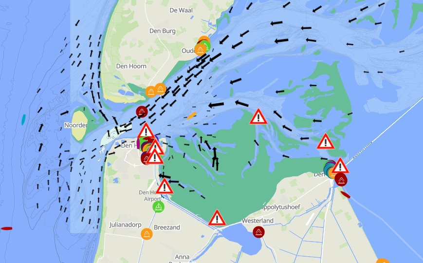
Current – the horizontal tide
Tidal movement creates an ebb current and a flood current. On most hydrographic charts you can use the tidal stream tables.
HP 33 now contains the current atlases. You can also use current slide charts.
These provide a general impression of current direction and strength and are a handy aid to see when you can depart or arrive.
They are not very precise, but they are practical.
Tides involve not only rising and falling water levels, but, also horizontal current in the water.
In Fig.7 you actually see outgoing tide from the Waddensea in between Den Helder and Texel.
With upcoming tide (from low water to high water), water "pushes" you towards land.
With offgoing tide (from high water to low water), water "pulls" you towards sea.
Tidal water levels determine whether you can continue, or get stuck, based upon your
draft. Therefore tides and their currents determine the most favourable times to depart/arrive.
Going to sea: From just before high tide, using the outgoing tide to pull you.
Coming from sea: Try to come into the mouth of a river at low tide, so the
tide will push you in.
Water level height – the rule of twelfths
Using the rule of twelfths you can estimate water depth. We assume there are on average 6 hours between HW and LW.
In the first hour, the change is 1/12 (add or subtract 1/12)
In the second hour, the change is 2/12 (so 3/12 total)
In the third hour, the change is 3/12 (so 6/12 total)
In the fourth hour, the change is 3/12 (so 9/12 total)
In the fifth hour, the change is 2/12 (so 11/12 total)
In the sixth hour, the change is 1/12 (so 12/12 total)
So the total range is divided into 12 parts. This is a rough estimate, but it works well enough.
Spring tides and neap tides
There are also spring tides and neap tides. In the first case the water reaches its highest highs and lowest lows; in the second case it does not rise or fall as much.
The tidal range is then smaller. You can estimate the difference between HWS (spring) and HWD (neap) with the one‑seventh rule,
because there are 7 days between HWS and HWD.
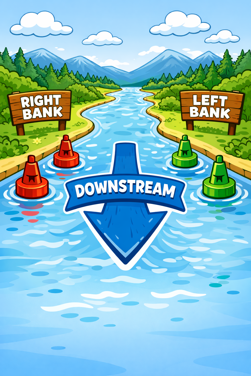
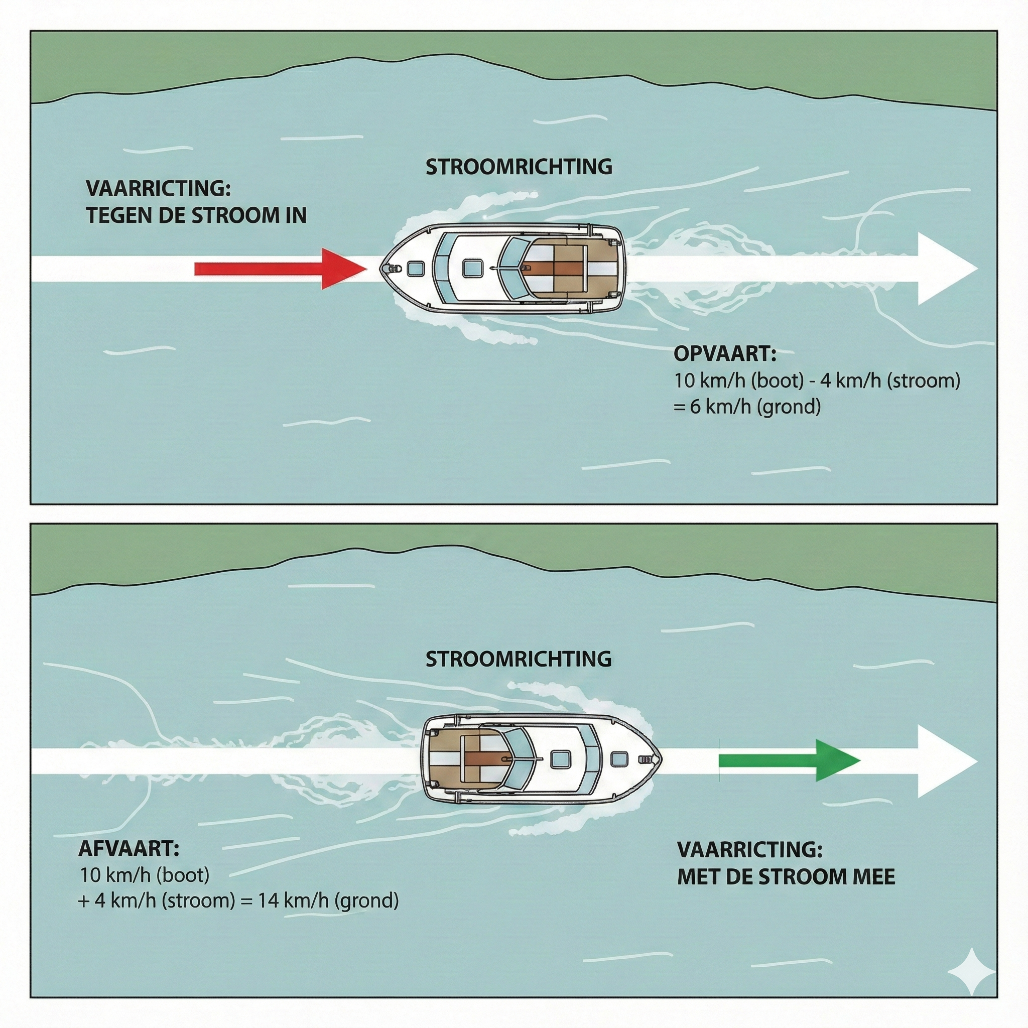
On this site, you've seen already a couple of times "Opvaart" or "Afvaart".
That are the dutch "slang words" for going Upstream or Downstream. As you can imagine,
going upstream, is way less fuel efficient than going downstream. For example the river
IJssel, that is fast-flowing, going Upstream, will take serious time and therefore also
serious amounts of fuel. Therefore, going in the "Afvaart" is economically way better.
The image here, will clarify what Opvaart and Afvaart mean and look like. In the image
the river flows from left to right. So, going from Right to Left, you are going against the
current. And going from Left to right, you are going with the current.
Here some of the definitions that must be clarified which are in place here:
Speed over Ground.
The real speed you will see on your GPS.
River Current
How fast the water flows trough the river.
Going with the flow: Add it to your STW (+)
Going against the flow: Substract it from your STW (-)
Why prefer downstream (Afvaart)?
Afvaart
10 km/h speed trough water + 4 km speed of the current = 14
km/h speed over ground.
Opvaart
10 km/h speed trough water - 4 km speed of the current = 6 km/h
speed over ground.
Note
Actually that is pretty simple to answer: Fighting yourself against
the current gives you a nice speed trought the water (STW), but a slow
speed over ground (SOG). When you are going downstream, you go with
the flow, and your speed trought the water will remain the same,
but the speed over ground will be:
(speed trough the water + water flow speed) = Faster Speed
over ground. (speed trough the water - water flow speed) = Slower Speed
over ground.
When using a Marine radio (Marifoon/VHF Set), and it's not your daily job, you might get
confused with what is what, and why?
We will try to clear things up in this section, so you will use your Marine radio with more
confidence. And you will receive the information you request and/or need.
What is What?
THE DIFFERENCES BETWEEN A VHF BLOCK CHANNEL AND THE NAUTICAL INFORMATION CHANNEL
Unintentionally mixing up or incorrectly calling a Traffic Centre using "Post" or "Sector" can result in a skipper being (undesirably) referred to a different VHF channel. Someone calling "sector" on the nautical information channel might, in theory, be told: "For navigation, channel... over."
Someone reporting voyage data on the VHF block channel will be presented with the prevailing traffic situation and referred to the nautical information channel.
To avoid confusion, it is therefore important to know who you need: the post or the sector. They both have different functions and their own call signs. It is quite useful to use them correctly.
► NAVIGATION: SECTOR
According to regulations, large vessels must simultaneously monitor the channels for ship-to-ship traffic and for nautical information. The ship-to-ship channel is channel 10, unless another channel has been designated as a block channel.
► SECTOR….. THE VHF BLOCK CHANNEL: A VHF block channel is assigned to a route, area, sector, river section, etc. On a designated block channel, vessels are mandatory required to listen in and handle nautical ship-to-ship communication and nautical (traffic) communication with the Traffic Centre. After all, the traffic control of a Traffic Centre has the call sign "sector" + the name of the Traffic Centre (Dordrecht/Wijk bij Duurstede/Tiel/Hansweert/Nijmegen etc.).
The call sign "sector" is likely derived from the word "Radar sector" and therefore always relates to radar, navigation, and traffic guidance. Making an agreement (to overtake or pass) on channel 10 within a VHF block area deviates from the regulations. This could result in other vessels, which are correctly monitoring the block channel, being surprised by these actions!
► In the "Regulation on communication and dimensions of National Inland Waterways", Annex 2 lists the locations (traffic centres) with VHF block channels. This regulation states that the skipper or captain of a (type of) vessel as referred to in Annex 2, navigating on a waterway section mentioned in that annex, must report in accordance with what is indicated in that annex.
We see that there are only a few locations where an (inland) vessel must report via the VHF block channel when entering or leaving a sector. We also see what, when, and to whom reporting on the block channel is mandatory, namely: When intending to perform a special manoeuvre, which includes:
1) Entering or leaving a port or side waterway
2) Turning and crossing the waterway
3) Anchoring or leaving an anchor or berth
None of the above situations applicable? Then reporting on the VHF block channel is usually* unnecessary.
Apart from communication to ensure safe passage, compliance can be understood as simply monitoring the block channel well and answering calls. The RPR/BPR as well as the communication regulations indicate in Annex 2 that vessels must monitor, communicate, and answer calls on the designated channel during the voyage within the block area. Reporting that you are "sailing straight ahead" likely does not fall under the three mentioned special manoeuvres in your view either and could therefore be seen as redundant communication. Except if a traffic situation and/or what you hear or see gives cause to do so.
*(Consult the "Regulation on communication and dimensions of National Inland Waterways". There are areas with exceptional regulations regarding checking in and/or out of a sector, such as Amsterdam and Rotterdam).
► INFORMATION: POST….
This is quite different when a Traffic Centre is called on the Nautical Information Channel using the call sign "Traffic Centre (Verkeerspost) + name of the Traffic Centre." This may concern:
1) The reporting obligation for the reporting and tracking system.
2) Providing or requesting information, such as available berths, reporting nautical peculiarities, inquiring about water depth for a loading or unloading quay, the next bridge opening, etc.
3) Handling emergency communication with a vessel in need, such as calling for medical assistance, or mutual communication with a Traffic Centre in case of calamities.
The reporting and tracking system allows the data belonging to the ship to "travel along" through a link with the AIS system. This allows, among other things, adequate assistance to be provided in case of calamities, and lockmasters can better anticipate the supply of ships.
► SHIPS SUBJECT TO REPORTING ACCORDING TO ARTICLE 12.1 RPR
Vessels empty of or loaded with dangerous (ADN) substances, all tankers (including cement/powder substance), a vessel with containers, a vessel longer than 110m, a convoy longer than 140m and wider than 15m, a hotel ship, a seagoing vessel, or a special transport, form the category of vessels that report on nautical information channel 64. (Call sign: "Post Millingen" or "Post Nijmegen" depending on the area).
► REPORTING OBLIGATION FOR OTHER VESSELS
At the border, there is a sign with VHF 19 and a sub-sign "Meldplicht" (Reporting Obligation) CBS Lobith. The Central Bureau of Statistics keeps track of incoming and outgoing flows of goods. Policy makers derive their data for numerous matters, such as indicating interests for shipping and maintaining waterways, from the statistical data of the CBS. It is for this reason that vessels not mentioned in Article 12.1 of the RPR have a reporting obligation on VHF channel 19 when sailing upstream or downstream.
► CHECKING IN AND OUT
Vessels that are required to register electronically only need to check in/out via VHF: A) when crossing the border, B) when entering RWS (Rijkswaterstaat) territory, C) at the start of a new voyage and/or voyage interruptions longer than 2 hours. German legislation requires certain data to be removed, while for passing locks in the Netherlands, for example, the statement of the draught is required. It is for this reason, in the run-up to improvements, that the waterway manager still asks for this when you check in. Due to the AIS link, progress reports for vessels mentioned in Art 12.1 RPR have been discontinued.
We try to update this website as often as possible!
The upgrade plans
24 Januari 2026
Our upgrade plans.
Support the KNRM!
Help them to help others!
KNRM
I would like to ask you to become a donor for the KNRM.
The KNRM is a fully private organisation, completely run by volunteers, financed by contributions and donations.
You will find all information about them on the website.
You can choose from a single one time payment or a monthly or yearly donation. Please Support them.
Our personal opinion is that every person out on the water should, by law be told to make a donation of €25,- per year.
But that is just our opinion.
Copyright, Disclaimer & Attribution
The legal stuff needed because of stupid....
The content on this website may include materials such as text, images, videos, and other media that are the property of their respective owners. All trademarks, logos, and copyrighted works remain the intellectual property of their original creators.
We strive to properly attribute and acknowledge all sources. If you are the copyright owner of any material featured on this site and believe it has been used without appropriate credit or permission, please contact us at [your contact email] so we can promptly address the issue.
Where applicable, the use of third-party content falls under fair use, creative commons licenses, or other applicable legal provisions. If specific attribution is required, it is provided directly alongside the respective material.
The images and data on this site are NOT intended for navigation or critical decision-making.
Any reliance on this information is strictly at your own risk. The information on this site is for PERSONAL USE ONLY.
You may print or copy parts of it for your own private use. Commercial use is strictly FORBIDDEN.
Do not sell, rent, or use this data for profit. Unauthorized commercial exploitation will be met with rigorous legal action to the fullest extent of the law
Furthermore, automated data scraping, harvesting, or feeding this content into large language models or AI systems is strictly PROHIBITED.
If automated tools crawl this site without express written permission, access will be blocked, and those responsible will be held liable for
unauthorized bandwidth usage and intellectual property infringement.