Why Routes?
Because we can plan....
Oh No! Not more routes!
While countless routes exist in both paper and digital formats, we wanted to share a curated selection of journeys that we believe offer the best experience for navigating yourself Skipper’s Responsibility: Always verify that your vessel’s specific dimensions (length, beam, draft, and air-draft) are compatible with the current waterway conditions. We provide these details for guidance, but final navigational safety rests with the skipper. .
Please Note: Waterways are dynamic environments. Routes are rarely "static" as maintenance work, shifting water levels, or updated local restrictions can influence the accessibility of a path relative to your boat's specifications.
Motivation
There is a unique joy in the transition from planning a voyage to actually casting off the lines. This is why we distinguish between "Routes Planned" and "Routes Done". Whether a route is a meticulously prepared itinerary or a log of a journey already completed, our goal is to spark your imagination and help you navigate toward your own unforgettable experiences.
Finding Your Way
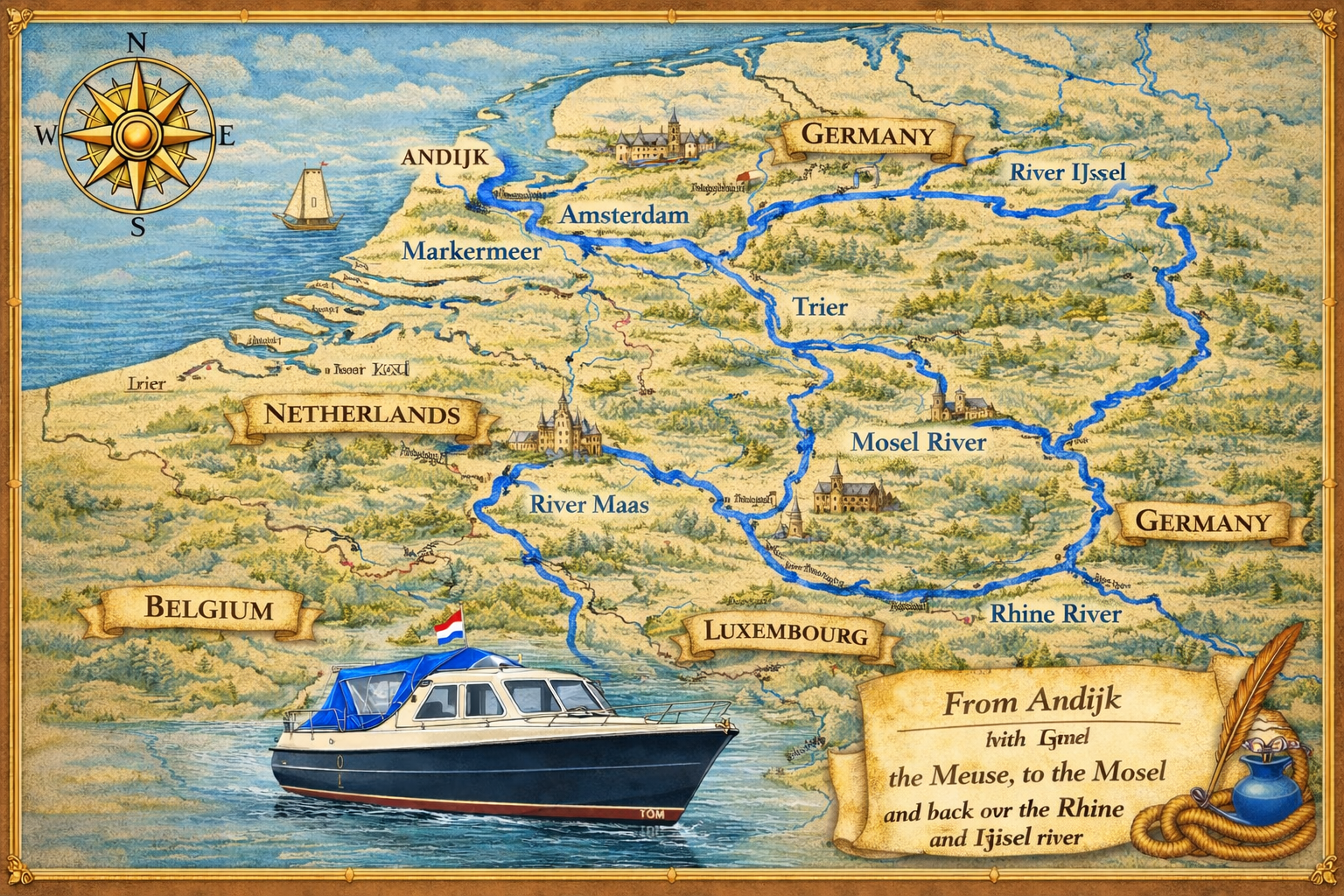
Our library is organized for easy browsing, categorized by geographic region or by named waterway networks, such as the expansive Meuse-Moselle-Rhine international circuit.
The level of detail varies—some stops feature deep-dive explanations of local highlights, while others provide a streamlined overview. Regardless of the depth, every entry is chosen because it has something unique to offer.
Technical Specifications
To ensure your vessel is a proper fit for the journey, we provide maximum allowable dimensions (length, width, draft, and air-draft/height) for every waterway covered. To help you interpret this data at a glance, please refer to our Legend of Symbols used throughout the route descriptions.
Interested in what’s over the horizon? Check out our "Routes Planned" section. While these are still works-in-progress, they offer a preview of the destinations and sights we are currently researching for our future adventures.
Disclaimer!
Because we have to....
All routes shown here were written and checked at the time they were planned. Because conditions can change, it’s always a good idea to double-check the details before you set off. We shall not accept any form of responsibility or liability if a route turns out to be blocked, longer than expected, or requires you to turn back.
Attention!
Most importantly: always check whether a route is suitable for your vessel. YOU are responsible for making sure your boat’s dimensions, draft, and height match the route. And just to be clear: Being “smaller than Tom” doesn’t automatically mean a route will work for you 😉
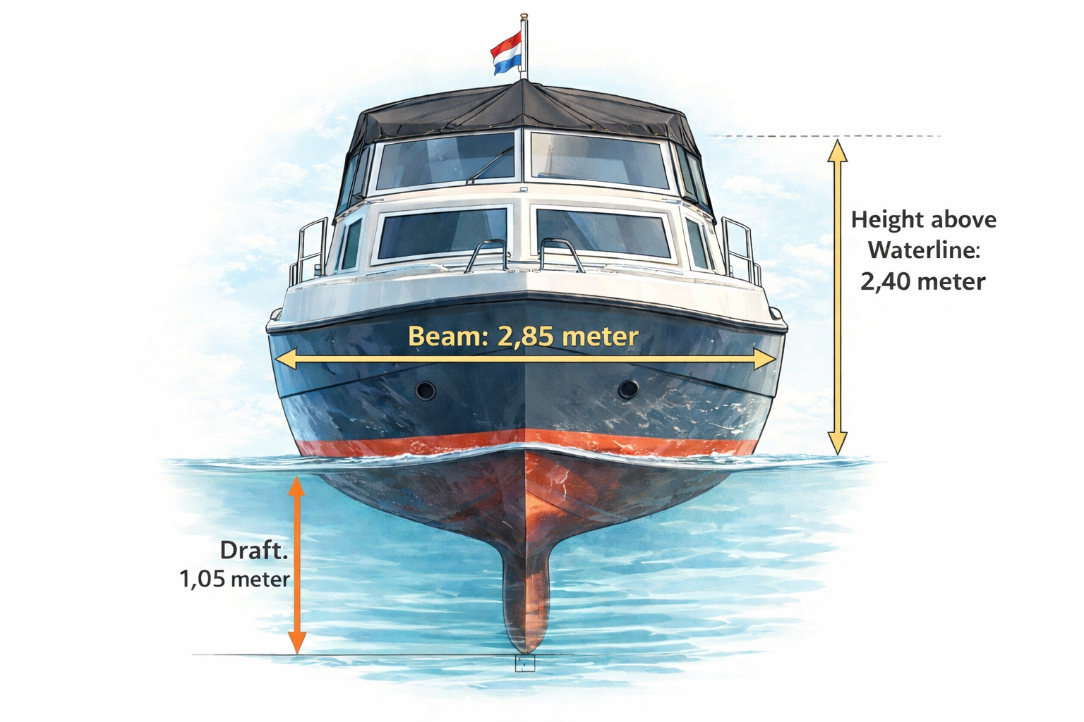
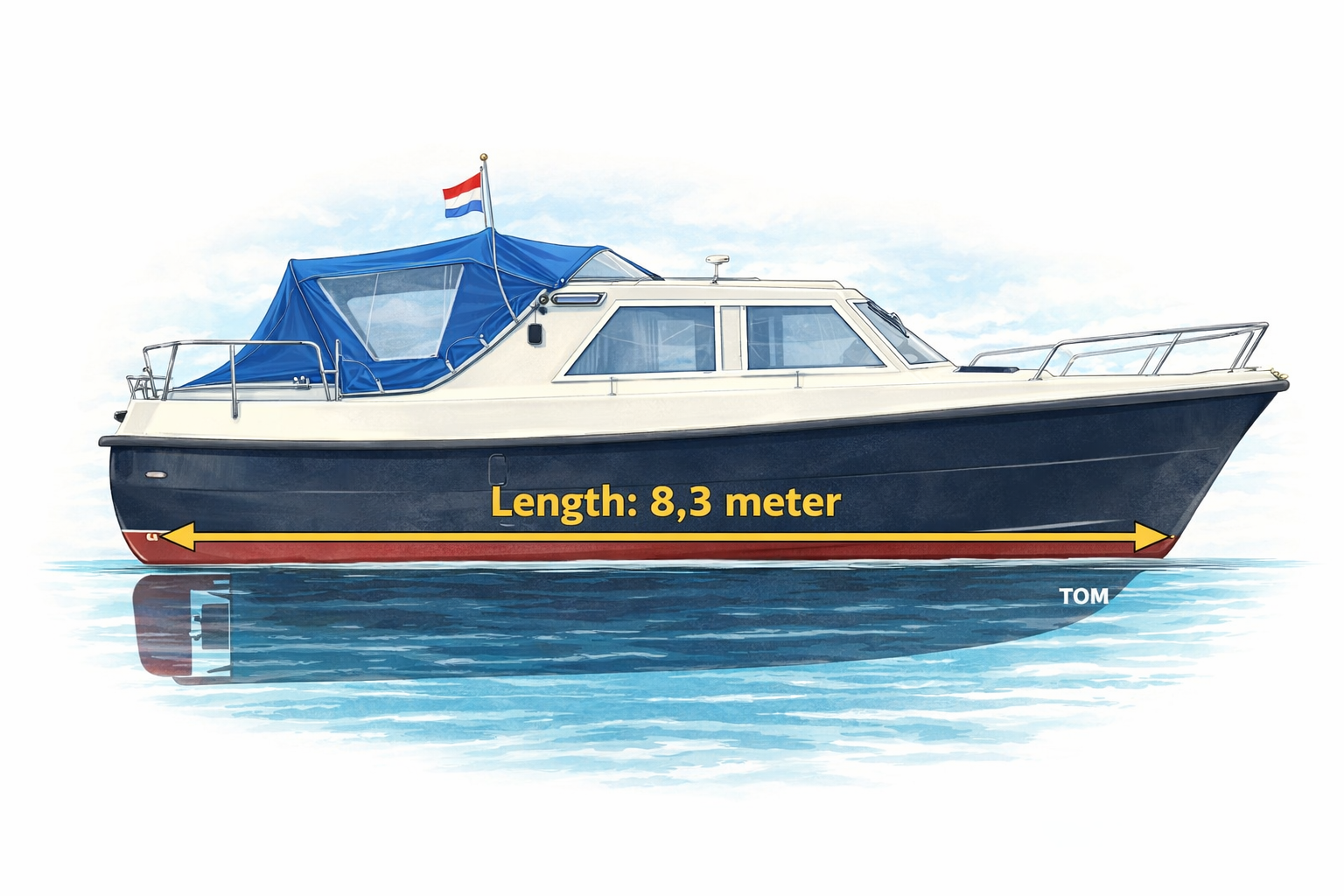
Tom's Actual Measurements
We use TOM's measurements to plan routes.
| Measurements | What |
|---|---|
| 8,23 meter | Length overall |
| 7,8 meter | Length over waterline |
| 2,85 meter | Width overall |
| 2,40 meter | Height (air draft) |
| 1,05 meter | Draft |
Routes Planned
New Routes!
Here are the new routes, which are ready to be used, or are still under construction. This means that the information in these plans must be checked before undertaking the route. Longer routes take some more time because we want to plan it as detailed as possible. In particular you should check (along the route):
-
NtMs
Notice to Mariners — official bulletins announcing temporary or permanent
changes to navigational infrastructure: waterways, bridges, locks, buoys, and depths.
Notice to Mariners
Temporary or permanent changes to:- Waterways
- Bridges
- Locks
- Buoys and Beacons
- Depths / Dredging
- NtSs Notice to Skippers — digital navigation warnings issued under RIS (River Information Services), the EU-mandated platform for inland waterway traffic management. Notice to Skippers (under RIS: River Information Services)
- Bridge clearances
- Depth information
- Lock details
- Fuel stations
- Availability of marinas
This implies that YOU should check the route with the measurements of your boat, and modify it to your needs! Or even decide that the route is not navigable for you.
| Date of Planning | Short Explanation | Link | Done |
|---|
Routes we have navigated
We travelled those
Down here, you will find the routes we already travelled with Tom. Some are longer, some are shorter. Some where planned, some caused by detours. And most of them where in the "Kop van Noord Holland" during 2025.
The links might take you to our (yearly) overview page(s), or to the planning page of that route.
| Date | Short Explanation | Link | Done |
|---|
Bonus Information!
EuRis and more....
Bonus Information for the Netherlands: Varen doe je Samen
Within the Netherlands we have alot of information regarding important waterway junctions. You can find this information on the website of the several partners on, and about the waterways. There are some very, very interesting cards and brochures you can download! We certainly would like to advice you to visit the site. Even Jacco, who is pretty experienced, was impressed with the very simple, but understandable explanations in those cards and brochures. And he's pretty sceptical about such things. And at this site you will find all the junctions per region.
Bonus Information Source for creating Routes: EuRis
The main waterways in Europe are maintained by goverments (or government agencies) and they joined up together in EuRis. They have a great route planner at: the Beta and The Real one. You can make your own account for free. Advantage of this tool is, that you have all available information at your fingertips.
Route Icon Legend
What is a legend?
Explanation of Symbols
Object Types
Navigation
Dimensions
Locks & Lifts
Marinas
Fuel Stations
General
Support the KNRM!
Help them to help others!
I would like to ask you to become a donor for the KNRM.
The KNRM is a fully private organisation, completely run by volunteers, financed by contributions and donations. You will find all information about them on the website.
You can choose from a single one time payment or a monthly or yearly donation. Please Support them.
Our personal opinion is that every person out on the water should, by law be told to make a donation of €25,- per year. But that is just our opinion.
Copyright, Disclaimer & Attribution
The legal stuff needed because of stupid....
The content on this website may include materials such as text, images, videos, and other media that are the property of their respective owners. All trademarks, logos, and copyrighted works remain the intellectual property of their original creators.
We strive to properly attribute and acknowledge all sources. If you are the copyright owner of any material featured on this site and believe it has been used without appropriate credit or permission, please contact us at [your contact email] so we can promptly address the issue.
Where applicable, the use of third-party content falls under fair use, creative commons licenses, or other applicable legal provisions. If specific attribution is required, it is provided directly alongside the respective material.
The images and data on this site are NOT intended for navigation or critical decision-making. Any reliance on this information is strictly at your own risk. The information on this site is for PERSONAL USE ONLY. You may print or copy parts of it for your own private use. Commercial use is strictly FORBIDDEN. Do not sell, rent, or use this data for profit. Unauthorized commercial exploitation will be met with rigorous legal action to the fullest extent of the law Furthermore, automated data scraping, harvesting, or feeding this content into large language models or AI systems is strictly PROHIBITED. If automated tools crawl this site without express written permission, access will be blocked, and those responsible will be held liable for unauthorized bandwidth usage and intellectual property infringement.
Powered by Haringstad
Build with VIM
© Haringstad, J and S van Koll