Germany: our eastern neighbor, and a boater’s paradise
Germany is our eastern neighbour and a country that lends itself extremely well to travelling by boat.
Its dense and well-maintained network of rivers, canals and coastal waterways makes it possible to plan
routes of almost any length or character. As of lately they also start to see the advantages of maintaining
a proper infrastructure for pleasure vessels. Specifically in (larger) Locks.
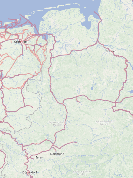
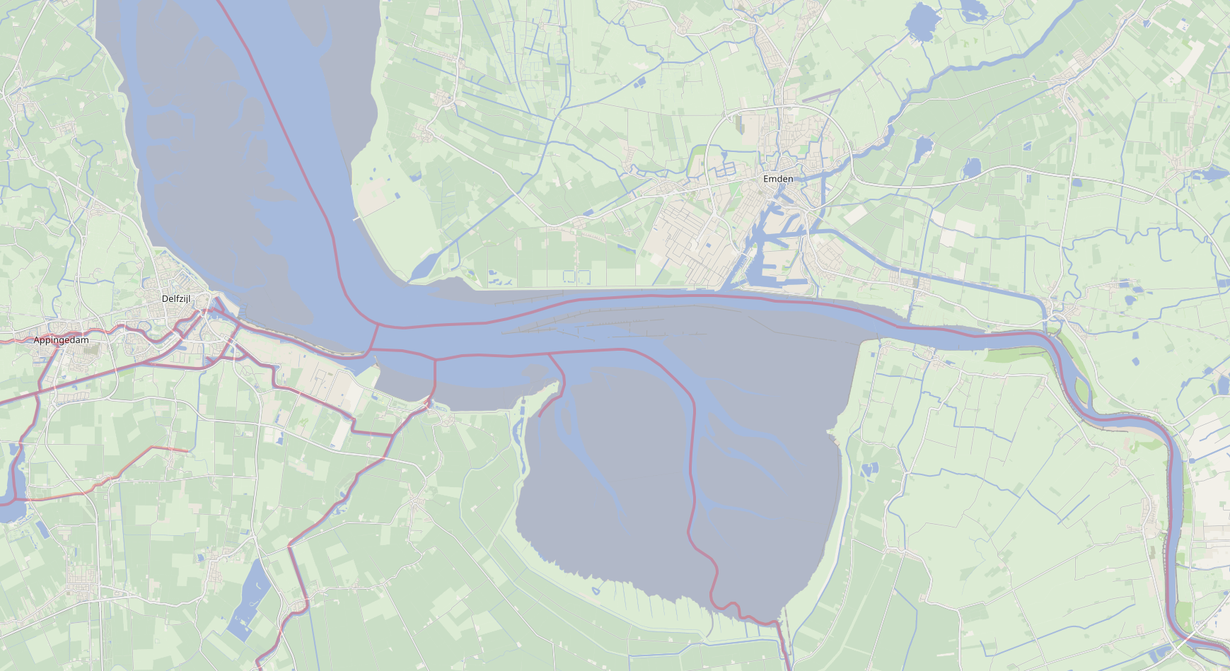
In the northwest, towns such as Emden, Leer and Papenburg
are attractive destinations in their own right, with a strong maritime character and good facilities for
pleasure craft. From here, routes continue towards larger ports such as Wilhelmshaven,
while longer passages can even lead as far as Kiel.
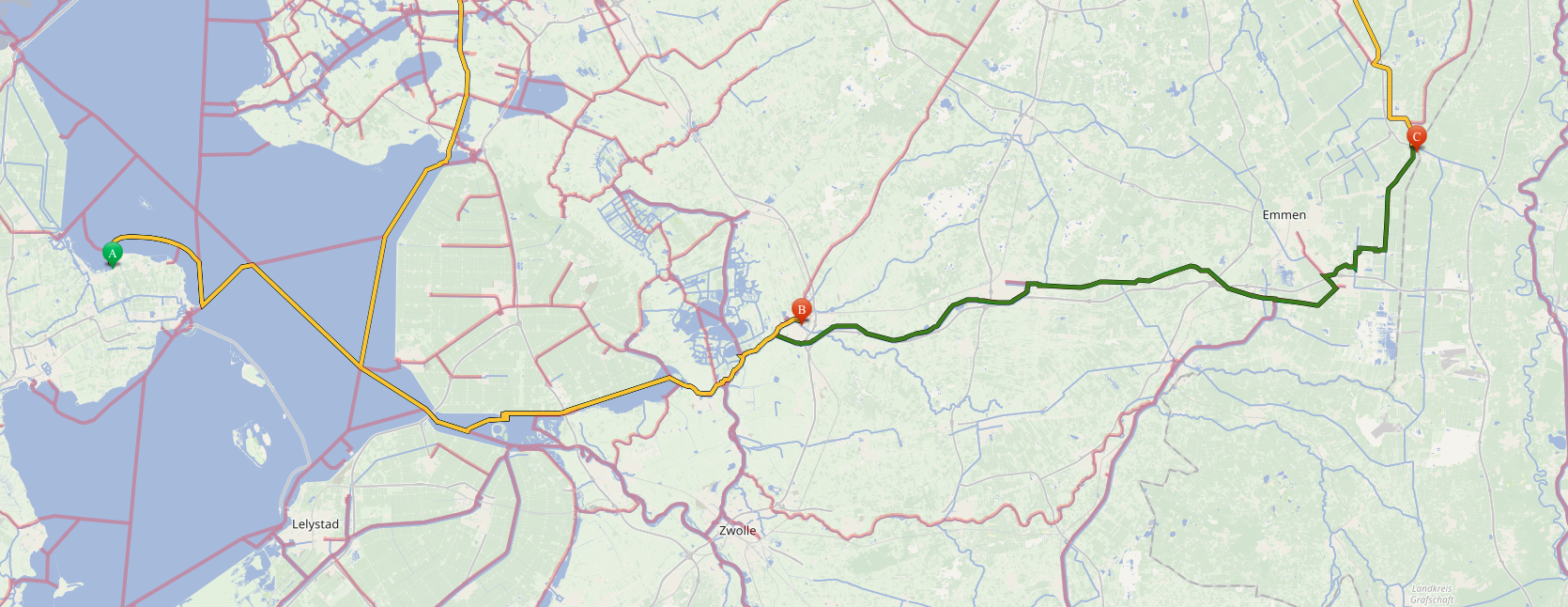
Heading south opens up a very different landscape. Inland waterways allow for journeys towards
Münster and further on to Koblenz, where the Moselle and the Rhine meet.
Along the way, the character of the route changes gradually from open waterways to narrower rivers with
towns and countryside close at hand.
By crossing the border from the North Sea, and using connections such as the
Haren–Rütenbrock Canal and the Rhine, a vast part of Germany becomes
accessible by water. Once inside this network, the number of possible routes is effectively unlimited,
making Germany an excellent destination for both shorter trips and extended voyages.
There are several ways to enter Germany from The Netherlands:
Northsea Routes -
Date:
From the Dutch coast
Along the Dutch Northsea coast, there are several routes to Germany. Those have different starting points
and different entry points. Below here you find some "wet finger" estimations from/to. In our opinion, those
routes are for sailboats, and are boring because of distances.
Nautical distances (NM) via waypoint Bol WA (53.47287, 5.48098) — except from Delfzijl (direct)
Emden
Wilhelmshaven
Bremerhaven
Cuxhaven
Hamburg
Den Helder
102.7
136.5
151.1
157.2
201.7
IJmuiden
130.9
164.7
179.4
185.5
229.9
Rotterdam
167.2
201.0
215.7
221.8
266.3
Scheveningen
155.2
189.0
203.7
209.7
254.2
Harlingen
80.2
114.0
128.7
134.7
179.2
Delfzijl (direct)
10.1
46.2
60.7
71.1
110.6
Per Location sets
Per location you can make your own calculations
Den Helder - Emden
From
Den Helder
To
Emden
Speed (plan)
9,5 km/h (≈5 kn)
Dist. KM
225
Den Helder - Wilhelmshafen
From
Den Helder
To
Wilhelmshafen
Speed (plan)
9,5 km/h (≈5 kn)
Dist. KM
325
You get the point
By now, you get the point. Going all the way over the northsea is boring for a
motor-vessel.
Waddensea Routes -
Date:
Fig.2 - Waddensea
Over the Waddensea
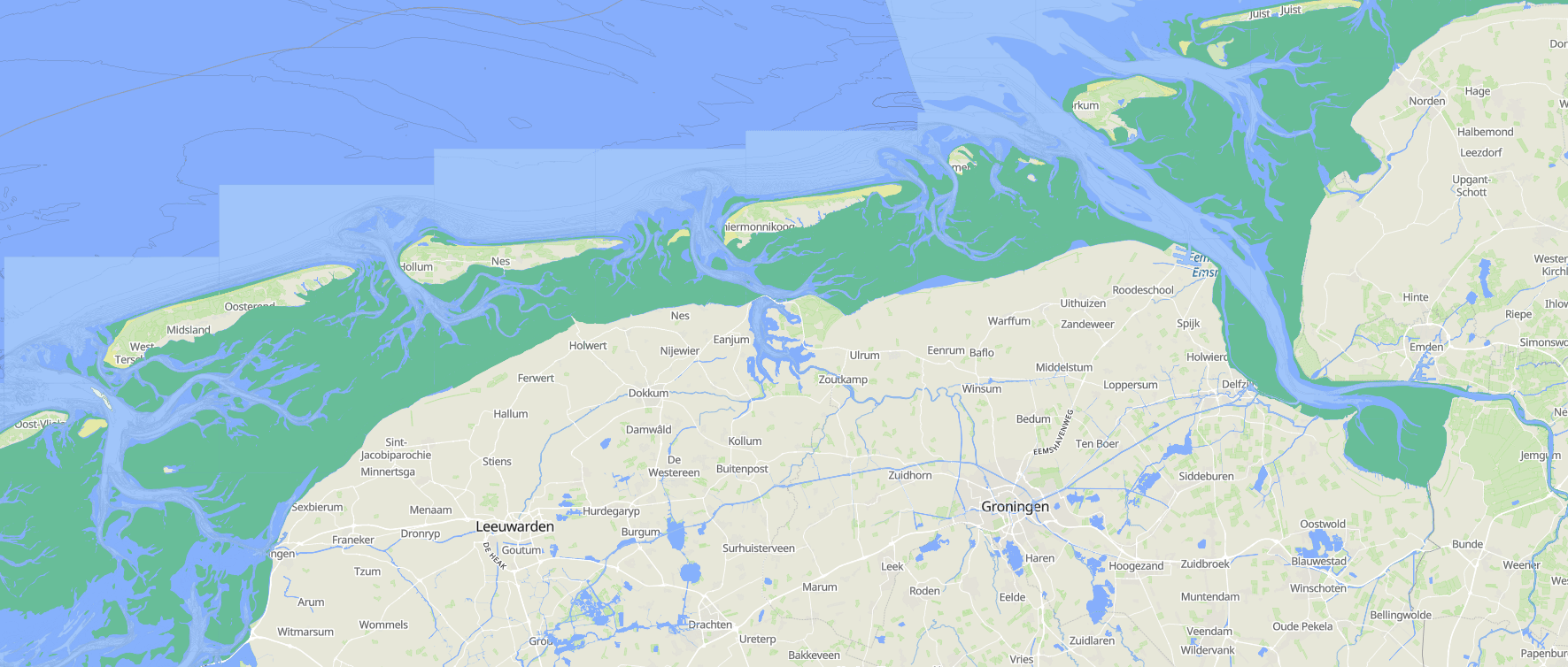
Along the Northern part of The Netherlands and Germany and the western side of Denmark, are the "Wadden islands",
and the "Waddensea" (The area between the Islands and the mainland).
In the Wadden Sea, the behaviour of tidal channels is not governed by tidal currents
alone. Wind is an equally important factor. The combined effect of tide and wind
continuously reshapes the seabed: channels can migrate, deepen, silt up, or shift
position altogether. As a result, a passage that is perfectly navigable today may be
partially blocked or even unsafe tomorrow! Especially after a period of strong or
persistent winds.
For that reason, it is essential to carry the latest official charts and tidal
information on board and to ensure they are updated with the most recent notices and
local updates. Treat any older route information with caution, and never assume that
yesterday’s depths, buoyage, or channel alignment will still be valid. If you are
navigating in shallow or shifting areas, plan conservatively: double-check the route,
confirm expected depths, and allow extra margins for safety.
Always factor the forecast into your decision-making. Wind direction and strength can
significantly affect water levels (set-up and set-down), wave conditions, and the
practical depth available over shoals. Make sure you have appropriate contingency plans
and safety measures in place for the scenario where you do touch bottom or become grounded,
such as clear communication procedures, sufficient fuel and provisions, and the ability to
wait safely for the next tide.
Rule of thumb: cross shallow areas on a rising tide. If you
attempt the crossing on a falling tide and run aground, the water will continue
to drop and you may have to wait much longer for enough depth to refloat. Ideally, time
your crossing close to the turn of the tide (around high water) so you still have a safety
margin and, if needed, the tide will not immediately work against you.
Having this said we can only tell you that when you want to make trips
from the Dutch part of the Waddensea to Germany, you have to plan those yourself, using
the latest information available, which you check right before you start your
trip. Not a month, not a week, but just a day before you start!
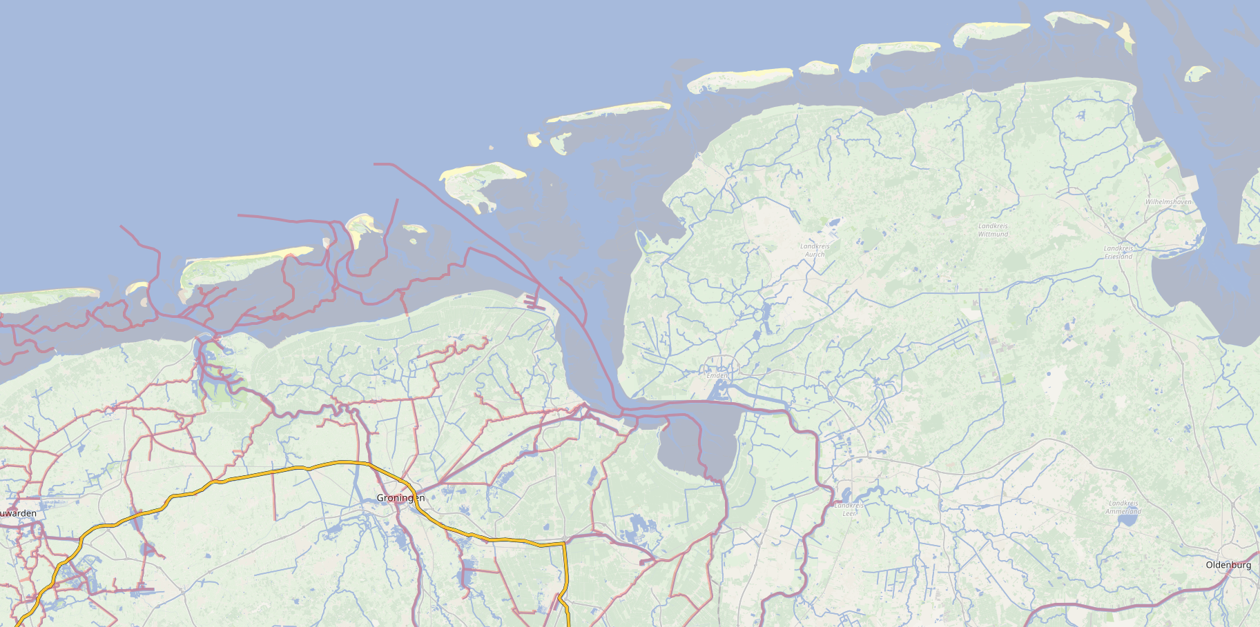
Dollard/Dollart Routes -
Date:
Fig.3 - Dollard/Dollart & Waddensea
Border Disputes
The Dollard (AKA Dollart) is the disputed border part between the Netherlands
and Germany. Where The Netherlands says: The border lays in the middle of the water,
Germany claims that the border is at the Dutch Shore. So, you can look at this from
2 different perspectives: The Dutch and German perspective. We will take the Dutch
perspective, because else this section would be very, very short and boring......
Although it is disputed, it is also an amazing area to navigate. There are (among others)
the following main-routes on the Dollard:
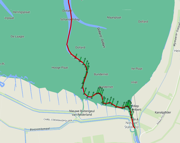
(*) A very adventurous route to take. You need proper preparations
for this section! (**) Series of the Canicula on Youtube
Due to the fact that all those are on tidal waters, and also the Dollard "acts" like the
Waddensea, you have to plan your trips properly and verify at the last moment if your plans
are still realistic.
Routes from/to Emden, Delfzijl, the Ems River or towards the Wadden- or Northsea are mostly
very well documented and deep enough. On the other hand, navigating to Nieuwe Statenzijl might
be a challenge!
From/To, All combinations are possible!
Fig.5 - Dollart Routes
The forementioned locations are reachable from all the other locations. But I guess that
became clear the moment you did see the image regarding the Dollard (Dollart).
Also for these parts, the same goes as for the Waddensea!
Make sure you have (very) recent water-charts. And that you have the
proper equipment and provisions. Wear your safety-vests. Also, download the KNRM APP
(Download your manual here)
Support the KNRM!
I would like to ask you to become a donor for the KNRM.
The KNRM is a fully private organisation, completely run by volunteers, financed by
contributions and donations. You will find all information about them on the
website. You can choose from a single one time payment
or a monthly or yearly donation. Please Support them. Our personal opinion is that every
person out on the water should, by law be told to make a donation of €25,- per year. But that
is just us.
Haren–Rütenbrock Routes -
Date:
Fig.6 - Haren–Rütenbrock
Inland Routes
One of the nice routes is the Haren–Rütenbrock canal
which takes you from the Netherlands to the Ems in Germany.
Fun fact is that when you want to navigate the canal, you have to do this in convoy.
This starts (coming from the Netherlands) at the first bridge. The highest boat needs
to be all the way up front so they can measure how high the bridges have to be opened.
The bridges are remotely controlled. In the canal, there are no places to "moor",
so you have to continue to the end of the canal.
This was documented about the Haren–Rütenbrock canal in 2008
The waterway from Ter Apel to Haren (Ems) on the Dortmund–Ems Canal
With the exception of the River Rhine, this is the only cross-border inland waterway connection with Germany.
The lock in the Haren–Rütenbrock Canal at the Dutch border is operated by the lock keeper
of the 7th Verlaat. The lock directly across the Dutch border is normally left open.
When arriving from Germany, vessels must, at the Dutch border near the ESSO petrol station
(Potze family) on the Rütenbrockerweg opposite the lock, contact the lock keeper of the 7th Verlaat
by telephone for the operation of the bridges and locks in the Dutch section of the
Haren–Rütenbrock Canal.
The telephone number is available at the petrol station (06-56 92 35 457).
See further instructions at the bridge.
Operation of structures in the Haren–Rütenbrock Canal (Germany)
The operating hours of the structures in the Haren–Rütenbrock Canal as known at the
time were:
From 1 April to 1 November
Monday to Friday: 08.00 – 12.30 and 13.00 – 18.00
Saturday: 08.00 – 13.00
Sundays and public holidays: closed
In exceptional cases, different operating hours could apply.
Due to the lack of mooring facilities, vessels were required to enter the canal
at least 2.5 hours before the end of the operating hours.
During the period from 1 November to 1 April, passage was only
possible after prior telephone notification, at least one week in advance.
Operation was carried out remotely from Haren (Ems). If required, contact could be
made with:
A. NLKW Operations Office Meppen
Haselühner Strasse 78
49716 Meppen
Tel. +49 5931 406 175
B. Schleuzel Operations Building
Tel. +49 5932 4376
Mobile: +49 171 477 2783
Haren as a stopover
While not to big, Haren is a very nice town to stay for a night (or more). Within walking
distance, there are nice restaurants, grocery shops and you are right in the middle of the
center. You'll also find a nice museum "Shiffsfahrtsmuseum". Certainly worth a visit.
Skipper's Information (HRK)
Here is some practical “skipper’s information” for the Haren–Rütenbrock Canal (HRK),
with emphasis on convoy sailing (Kolonnenschleusungen), transit rules, and what you
need to plan for in practice.
Convoy navigation (Kolonnenschleusungen) and meeting restrictions
During construction or maintenance works, the HRK may be operated with convoy lockages
from both directions, without opposing traffic in the work section.
In practice this means:
You navigate through the canal in a group/convoy (one after another);
There are fixed “entry windows” at the locks;
You cannot simply stop or moor along the way if you miss your slot: if you are late,
you will normally be held back until the next convoy or operating period.
Example of such a regime (season 2025 due to bridge and construction works):
Entry at Schleuse 1 (Haren): 08:00–10:00
Entry at Grenzschleuse (Rütenbrock): 13:00–15:00
Note: these time windows were explicitly published for the limited 2025 navigation season.
For 2026, times and procedures may change; always check the latest official notices before
departure.
Season, closures, and lack of flexibility
In 2025, the canal was only partially open due to construction works and then closed
from 30 September, with reopening announced for the 2026 season. Temporary closures,
changed operating hours, or additional waiting times may occur due to ongoing works.
Some sources emphasise that you cannot enter late in the day, because the entire route
must be completed in one run. In practical terms: you must enter well before the end of
the operating window.
Dimensions, draught, and temporary restrictions
During the 2025 works, the maximum permitted beam was temporarily reduced from 6.00 m to 5.50 m.
Always verify whether this restriction still applies in the season you intend to transit.
Locks and bridges: what to expect en route
Expect several locks and bridges along the canal. There are references to approximately
four locks and twelve bridges, operated and coordinated from Schleuse 1 in Haren.
In practice this means: have fenders and mooring lines ready, and maintain proper spacing
and speed discipline when sailing in convoy.
The same source provides links to the official tariff regulations and the canal usage
regulations, which are useful to download or print and keep on board.
Practical navigation tips (very relevant on the day itself)
Plan to transit the canal in one continuous passage. Do not rely on convenient waiting or
resting places to recover from a missed entry window.
Arrive early at the entry lock, especially when convoy sailing is in force. Make sure you
are ready well before the opening window, with lines, fenders, and communications prepared.
Allow for waiting time caused by construction works and lock operation, and expect a
strict no-meeting rule in work sections, meaning little operational flexibility.
Shortly before departure, always check the latest “Notices to Skippers” for the HRK and,
if applicable, the ELWIS/WSV publications for current operating times and any temporary
restrictions.
How to get to the Rütenbrock entrance of the Canal
Globally there are 2 main routes:
From the North (Ter Apelerkanaal)
From the South (Stads-Compascuumkanaal)
Both routes go over inland canals in The Netherlands. And both bring you to
the Barnflair Bridge & Lock. The Bridge is a "Lifting Bridge" and the lock is normally
open.
From the North
When you use the route from the North, you will face objects on the route. For example:
When you navigate from Winschoten, along Stadskanaal to Barnflair, it is approx. 45 km.
But there will be at least 6 locks and 51 bridges on this entire stretch.
Another route takes you from Center city Groningen to Barnflair: Approx 65 km, 34 bridges and 2 locks.
So, seen from Andijk you can take the northern route(s):
(***) This was from the Princess Margrietkanaal, mainly the route
taken bij Jacco in 2008.
From the South
Fig.7 - Erica - Barnflair
In 2008, when Jacco made this trip, this route was NOT available.
The route south to Meppel became available in May 2013. It is also known as the Erica - Ter Apel route.
This route connects the southern parts and northern parts again. The connections where not
navigable since end 1969 (according to local information). The restored route was originaly meant
to transport fuel.
We can make a long story short: The old routes used for inland transportation, that have between
not in use from the late 1960's, are (or have been) made available for pleasure vessels to navigate.
Places like Emmen are now reachable by boat again. (Not that there are ANY facilities in Emmen!)
For Example: When you navigate from Almelo, it is possible to navigate (globally) towards Coevoorden
and there head to Barnflair. (Be aware of your dimensions!)
From Haren into Germany
Date:
Technically, at the German side of the HRK, you have the same situation as in The Netherlands:
Going North on the Dortmund–Ems Kanal
Going South on the Dortmund–Ems Kanal
Alias for the Dortmund–Ems Kanal is DEK
Both routes have their charmes and options. The route North takes you to the connection
of the Küstenkanal near Dörpen, or to Herbrum, where you go from fresh to salt water at the lock.
Further North you can enter the Leda, or take other connections inland towards the east and
finally end up on the Dollard.
The route South takes you to Dortmund, and even further into Germany. Along the DEK there
are other canals connecting taking you further east. And this route you can also reach the Rhine
river to head back to The Netherlands.
In 2008, only the east basin of Lock Herbrum was available.
Now the west basin is in use.
The old lock and pleasure craft
As you can see on the picture, the old chamber of the lock was not very "pleasure craft"
friendly. Actually, it was even more pleasure craft unfriendly than the other
locks on the DEK. In 2008, only the eastern lock chamber at Herbrum Lock was in operation.
Today, the western lock chamber is in use, while the old one has been closed and completely
filled with earth. The former lock chamber was extremely unfriendly to recreational boating.
As can be seen in the photograph, the lock was clearly designed for commercial shipping.
The other locks, with their coarse sheet pile walls and almost no bollards, were and still
are not particularly pleasant for pleasure craft either, but this lock was a real challenge.
This was especially true because the lock transitions from fresh water to salt water.
This has surprised many boat owners making this passage for the first time.
Salt water is heavier than fresh water and therefore enters the lock beneath the fresh water.
As a result, the fresh water pushes vessels toward the salt water side, creating a current
inside the lock that runs from aft to forward. Most people expect the current to come from ahead.
Not in this lock.
As can also be seen in the photograph, there was very little opportunity for pleasure craft
to secure themselves properly due to the lack of bollards. In 2008, Erwi was therefore secured
on the right side of the photograph, to the wooden structure in the right foreground.
With considerable effort and improvisation, it was possible to keep Erwi in position.
It was far from ideal.
Fun Fact: The moment you are coming up the EMS from the DOLLARD and heading
for Dörpen, you will enter lock Herbrum. See also the route of the Canicula
where they take the HRK to Haren and then the DEK to Herbrum. And from Herbrum to
Ditzum.
Heading south
When heading south, you are heading towards connections that taken you further into the eastern
parts of Germany, like the "Mittellandkanal" all the way to the Elbe river.
Or going to Munster, connecting to the Datteln-Hamm-kanal that brings you to
(obvious) Hamm, and connecting at Datteln to the Rhein-Herne-kanal. The Rhein-Herne-kanal will
take you to the Rhine river at Duisburg (obviously).
The Rhein Route -
Date:
Fig.10 - Rhein 🇩🇪
Crossing the border on the Rhein 🇩🇪
For people with a large wallet, you can surely take the route
in de opvaart"
on the Rhine (Rhein) river. The "Rhein" enters between Spijk and
Millingen aan de Rijn, the Netherlands. Between those two locations, the rhine is
the border between The Netherlands and Germany.
You can go up the Rhine and take (amongst others) the following connections (besides marina's and harbors):
KM 864: Entry to Griethouser Altrhein
KM 813: Entry to Wesel-Datteln Kanal
KM 780.5: Entry to Hafen Kanal - Rhein-Herne Kanal
German Waterways
24 Januari 2026 -
Fig.9 - Main North-Western Waterways Germany
Main Waterways in Germany
There are many, many waterways in Germany. Most are shortened, some are fully named.
We will try to make a short list of the short names of the waterways we are mentioning.
By creating this list, you have some oversight of what is where and how to reach it.
We will try to update this as often as possible if there are significant changes. But
probably this will be a very static database. However, it gives you leads to where
each waterway will connect and where you can go. (theoretically)
We don't list ALL the waterways here, because that is just insane. We are not the proper
entity to do so, but we want to provide you general ideas of how to reach what, and from where.
Notice! We do try to use the official information from (Eu)Ris and other sources
from the German instances/agencies. The smaller waterways that aren't covered, we can't provide
accurate information for. We hope you'll understand this. On this site there are enough disclaimers,
so please understand you cannot hold us responsible for any wrong information.
German Waterways
Short
Name
Length
Start
Finish
Connects
Main Navigation
24 Januari 2026
We try to update this website as often as possible!
The upgrade plans
24 Januari 2026
Our upgrade plans.
Copyright, Disclaimer & Attribution
The content on this website may include materials such as text, images, videos, and other media that are the property of their respective owners. All trademarks, logos, and copyrighted works remain the intellectual property of their original creators.
We strive to properly attribute and acknowledge all sources. If you are the copyright owner of any material featured on this site and believe it has been used without appropriate credit or permission, please contact us at [your contact email] so we can promptly address the issue.
Where applicable, the use of third-party content falls under fair use, creative commons licenses, or other applicable legal provisions. If specific attribution is required, it is provided directly alongside the respective material.
The images on this site are NOT for navigation. Never. NOT. Use them for that and it’s your fault, your problem.
Sue me over it, and the court will officially record you as dumber than rubber dog shit from Hong Kong.