Welcome to Luxembourg!
Balancing a border:
Luxembourg & Germany →/
Entering Luxembourg

We are still on the Moezel (Mosel, Moselle, Moezel) river and we are heading downstream Travelling in the direction of the river's current, toward the sea. On the Mosel, this means heading toward Koblenz where the river joins the Rhine. , heading towards Koblenz, where we will join the Rhine river to get back to The Netherlands. But first, Luxembourg!
Notice! Important information regarding boating in Luxembourg
can be found on this website: https://www.service-navigation.lu/de/reglementation-de
Make sure to check this page for relevant info. Make sure you use the Wasserstraße Mosel
menu item!
This section of the trip is the most fun to do. Because here you are really boating on the river, that is the border between a small part of France, Germany and Luxembourg. It starts at Écluse d'Apach 🇫🇷 and ends at Wasserbillig 🇱🇺, where the Sauer River flows into the Mosel. After Écluse d'Apach 🇫🇷 where the mouth of the lock becomes wider, you will enter the part where the river is the border between Germany 🇩🇪 and Luxembourg 🇱🇺.
What about that Flag?
Yes, that flag sometimes gives some confusion. But it is pretty simple. The flag of the Netherlands is more RED and the flag of Luxembourg is more towards ORANGE. Also the shades of BLUE are different. And the proportions of the flags are different. The official name of Luxembourg is Grand Duchy of Luxembourg. More on the flag you can find here.
Information about this leg
Port side is Luxembourg (left bank) but also the German border
Starboard side is Germany (right bank) but is also the Luxembourg border
Important Information
Attention! Heading downstream, so counting backwards on the km markers!
Important! Marine Radio VHF (Very High Frequency) radio used for communication with other vessels, locks, bridges, and traffic control. Channel 10 is the general information channel on this section of the Mosel. usage is, when you have one, mandatory. Check the signs on the maps and the banks of the waterway!
From here: we continue where we left France
Travel day 4 towards Saarburg
Day four: Cross the border 🇫🇷→🇱🇺/🇩🇪
From Apach 🇫🇷 to Schwebsange 🇱🇺
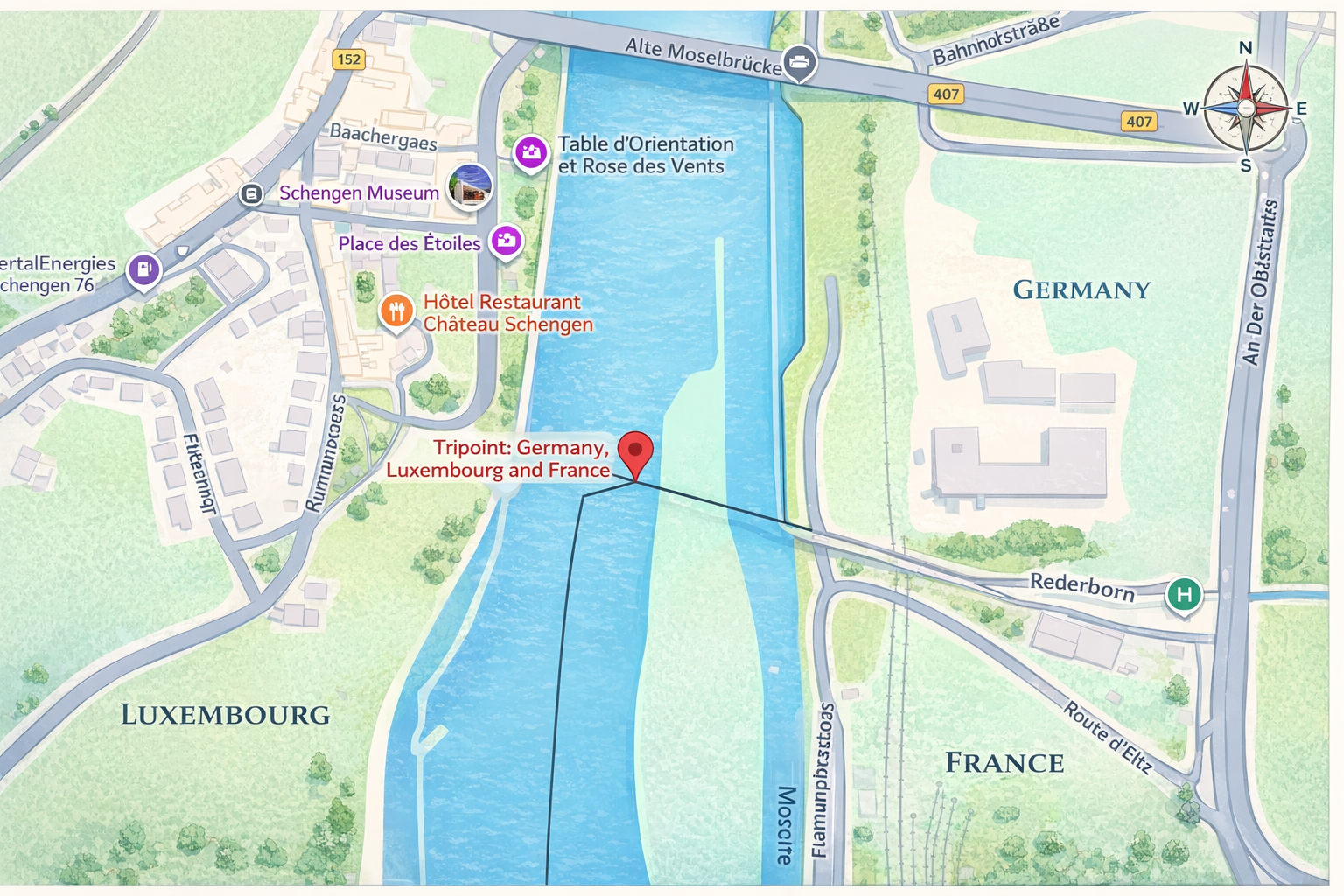
When crossing the border at Apach / Schengen, you pass the TriPoint The three-country border point where France, Luxembourg, and Germany meet, located in the Mosel near Schengen. Travelling by boat, you pass through all three national territories within metres of each other. , while continuing on the waterway between Luxembourg and Germany. While the transition between these three nations might seem unusual, the natural boundary between Luxembourg and Germany is actually defined by the Mosel River. In this region, where the waterway is locally referred to as the Mosel, the river functions as a shared condominium An international law arrangement in which two states exercise joint sovereignty over the same territory simultaneously. Neither country owns the river exclusively — both do, for its full width. : a unique arrangement where the entire width of the water belongs to both countries simultaneously.
Be Aware that you should inform yourself regarding rules & regulations of this part of waterway. Because how stupid it may sound: both countries have jurisdiction.
Important! You are crossing the border and leaving France. Check if your (personal) papers are valid for entering Luxembourg/Germany.
The route of today
On this section of the route you will pass the objects:
Upcoming stop: Marina Schwebsange.
At this marina there is a fuel station available. Only, this has specific
opening hours. Please inform when the gas-station is opened. Also, there is
a bread-vending-machine, where you can get your bread.
Travel day 5 towards Saarburg
Day five: Shop stop? 🇱🇺/🇩🇪
From Schwebsange 🇱🇺 to Wasserbillig 🇱🇺
After filling all possible tanks and jerrycans at Schwebsange1, the route continues towards Wasserbillig. For those that want to make a short stop at Remich to buy groceries, you can stop at the quay at Nennig (right bank) after passing the bridge, then cross the bridge into Remich.
The route section 1 of today
On this section of the route you will pass the objects:
Remich
By stopping at the quay at Nennig, you can cross the bridge and get groceries!
The route section 2 of today
On this section of the route you will pass the objects:
Upcoming stop: Wasserbillig.

Wasserbillig 🇱🇺 is the last stop within Luxembourg 🇱🇺. As seen on the map-section provided by Luxembourg authorities, there is a quay where you can moor for the night. It provides both Electricity and water. It is part of the Municipality of Mertert (Administration Communale de Mertert) Phone: +3527400161
Along the route, on several quays you will see information regarding if you are allowed to moor there. This section should be allowed during the entire season. From here, several shops are reachable. Note: Getting Fuel here, is the cheapest way before entering Germany and later The Netherlands.
Nearby Services - Port de Plaisance Wasserbillig
-
Closest Supermarket: Zika Grenzmarkt
Location: 67 Rte de Wasserbillig, Wasserbillig
Distance: Approx. 450m (6-minute walk from the harbor)
Best for: Quick groceries, local specialties, and tax-free items like coffee and tobacco. -
Main Shopping Center: Copal Shopping Center (Cactus)
Location: 24 Route d'Echternach, Wasserbillig
Distance: Approx. 1.2 km (15-minute walk)
Best for: Full grocery range, household goods, and a larger variety of international brands. -
Note on Fuel: High-Density Fuel Hub (Road Only)
Status: There is no dedicated marine fuel station directly at the harbor docks.
Nearest option: Circle K / Luxoil or Aral (Route de Wasserbillig) are within 500m.
Recommendation: Wasserbillig is famous for lower fuel prices in Luxembourg; these stations are easily reached on foot with a jerrycan, but not directly accessible by boat.
Please continue in the German Section, by clicking on the flag below here.
Important! You are on the border between Luxembourg 🇱🇺 and Germany 🇩🇪. Check if your (personal) papers are valid for entering Luxembourg/Germany.
Welcome to Germany!
Crossing the border →
Passing Mosel Marker 205.850 🇱🇺/🇩🇪
Which countries will this route pass?
These are the 5 (five) countries we are going to visit. Please use the links to get to the specific chapters (or routes, or legs) of each country.
We added, for good measurement, the ISO Country and the International country-code for calling. There are objects (locks, bridges, etc) that you have to call and do not have any VHF radio. (Or we could not find the VHF information.)
List of Countries
NL - +31
Many canals & rivers (Depending on the chosen route).BE - +32
Mostly Zuid-Willemsvaart, the Albert Canal and the Meuse River.FR - +33
Meuse River, many canals and the Moselle River. Many canals because of the chance of detours.LUX - +352
Moselle River. Shortest stretch.DE - +49
The Moselle, the Saar and the Rhine River.NL - +31
Many canals & rivers (Depending on the chosen route).Of all five countries, we'll only be in Luxembourg for a short stretch: just the section of the Moselle that lies wedged between France, Germany, and Luxembourg. It starts at Écluse d'Apach (FR) and ends at Wasserbillig (LUX), where the Sauer River flows into the Moselle. On this approximately 36 km long stretch, we'll be boating right along the border between Luxembourg and Germany. More about this will follow in the section covering this part of the route.
Support the KNRM!
Help them to help others!
I would like to ask you to become a donor for the KNRM.
The KNRM is a fully private organisation, completely run by volunteers, financed by contributions and donations. You will find all information about them on the website.
You can choose from a single one time payment or a monthly or yearly donation. Please Support them.
Our personal opinion is that every person out on the water should, by law be told to make a donation of €25,- per year. But that is just our opinion.
Copyright, Disclaimer & Attribution
The legal stuff needed because of stupid....
The content on this website may include materials such as text, images, videos, and other media that are the property of their respective owners. All trademarks, logos, and copyrighted works remain the intellectual property of their original creators.
We strive to properly attribute and acknowledge all sources. If you are the copyright owner of any material featured on this site and believe it has been used without appropriate credit or permission, please contact us at [your contact email] so we can promptly address the issue.
Where applicable, the use of third-party content falls under fair use, creative commons licenses, or other applicable legal provisions. If specific attribution is required, it is provided directly alongside the respective material.
The images and data on this site are NOT intended for navigation or critical decision-making. Any reliance on this information is strictly at your own risk. The information on this site is for PERSONAL USE ONLY. You may print or copy parts of it for your own private use. Commercial use is strictly FORBIDDEN. Do not sell, rent, or use this data for profit. Unauthorized commercial exploitation will be met with rigorous legal action to the fullest extent of the law Furthermore, automated data scraping, harvesting, or feeding this content into large language models or AI systems is strictly PROHIBITED. If automated tools crawl this site without express written permission, access will be blocked, and those responsible will be held liable for unauthorized bandwidth usage and intellectual property infringement.
Powered by Haringstad
Build with VIM
© Haringstad, J and S van Koll