Why Routes?
Because we can....
Aren't there already enough routes available on the internet?
There are plenty of routes available, both on paper and in digital form. Still, we’d like to share a selection of routes that you can actually enjoy navigating yourself. Routes are never completely fixed because of construction work, changing waterways, or new restrictions can all affect what’s possible.
Planning a route is fun, but travelling it is even better. That’s why we talk about "Routes Planned" and "Routes Done". Some routes are carefully prepared in advance, others are the result of real journeys we’ve already made. We hope they inspire you and help you create some great experiences of your own.
Navigate the Routes
24 Januari 2026
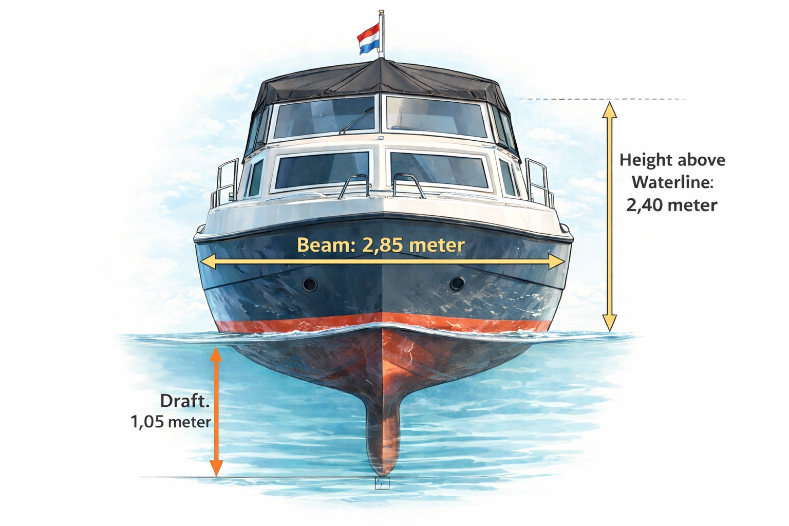
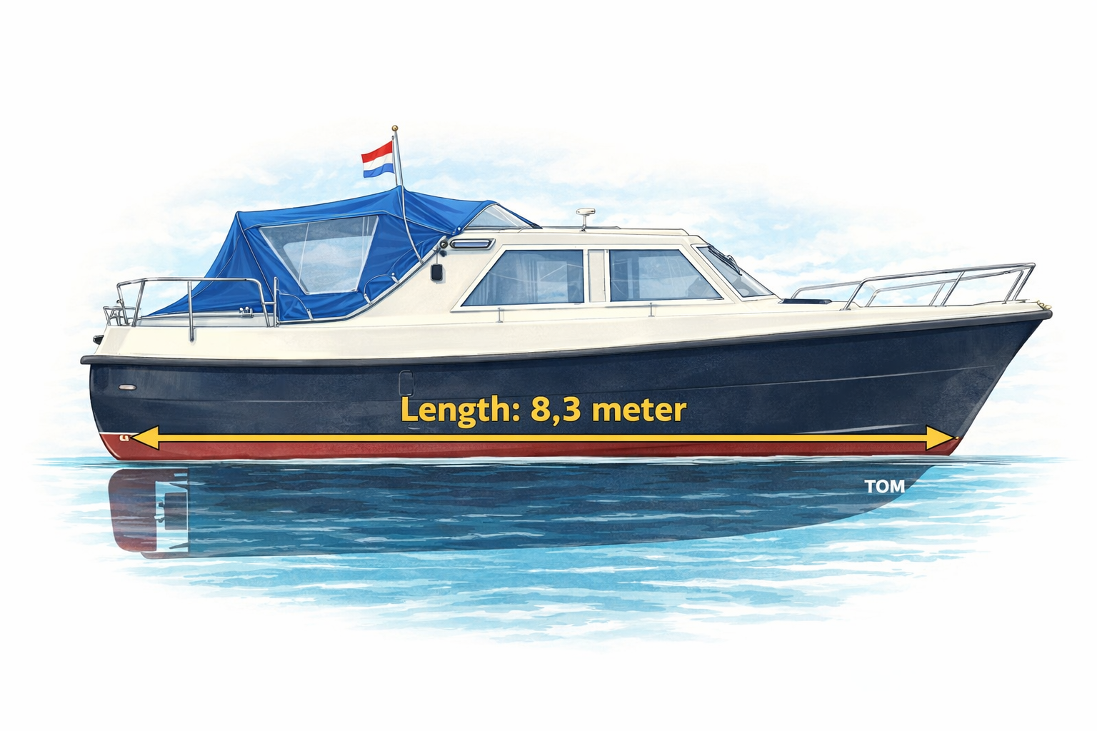
Tom's Actual Measurements
We use TOM's measurements to plan routes.
| Measurements | What |
|---|---|
| 8,05 meter | Length overall |
| 7,3 meter | Length over waterline |
| 2,85 meter | Width overall |
| 2,40 meter | Height (air draft) |
| 1,05 meter | Draft |
Routes Planned
New Routes!
Here are the new routes, which are ready to be used, or are still under construction. This means that the information in these plans must be checked before undertaking the route. Longer routes take some more time because we want to plan it as detailed as possible. In particular you should check (along the route):
- NtM's Notice to Mariners
Temporary or permanent changes to:- Waterways
- Bridges
- Locks
- Buoys and Beacons
- Depths / Dredging
- NtS's Notice to Skippers (under RIS: River Information Services)
- Bridge clearances
- Depth information
- Lock details
- Fuel stations
- Availability of marinas
This implies that YOU should check the route with the measurements of your boat, and modify it to your needs! Or even decide that the route is not navigable for you.
| Date of Planning | Short Explanation | Link | Done |
|---|---|---|---|
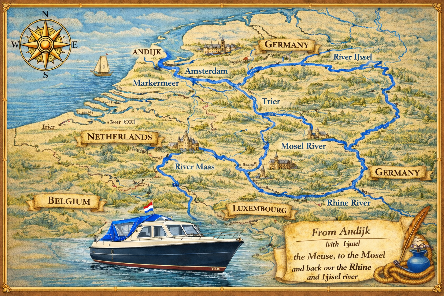
| 17-10-2025 | The famous "Meuse → Mosel →
Rhine" route. (Under construction) |
View | |
| 14-08-2025 | Andijk (start) → Medemblik → Kolhorn → Broek op Langedijk → Alkmaar → Akersloot → Spijkerboor → Avenhorn → Beets → Oosthuizen → Purmerend → Edam → Enkhuizen → Andijk (Finish) | View | |
| 13-06-2025 | Andijk → Meppel → Klazienaveen →
Haren (Under construction) |
View | |
| 14-06-2025 | Haren → Dorpen | View |
Routes we have navigated
We travelled those
Down here, you will find the routes we already travelled with Tom. Some are longer, some are shorter. Some where planned, some caused by detours. And most of them where in the "Kop van Noord Holland" during 2025.
The links might take you to our (yearly) overview page(s), or to the planning page of that route.
| Date | Short Explanation | Link | Done |
|---|---|---|---|
| 05-04-2025 | Our first trip: Kollum → Lemmer | View | |
| 06-04-2025 | Lemmer → Andijk | View | |
| 04-07-2025 | Andijk → Den Oever → Slootdorp → de Haukes | View | |
| 05-07-2025 | De Haukes → Pishoek → Middenmeer → Andijk | View | |
| 07-08-2025 | Andijk → Medemblik → Middenmeer → Kolhorn | View | |
| 09-08-2025 | Kolhorn → Pishoek → De Haukes → Slootdorp → Den Oever → Andijk | View |
Copyright, Disclaimer & Attribution
The content on this website may include materials such as text, images, videos, and other media that are the property of their respective owners. All trademarks, logos, and copyrighted works remain the intellectual property of their original creators.
We strive to properly attribute and acknowledge all sources. If you are the copyright owner of any material featured on this site and believe it has been used without appropriate credit or permission, please contact us at [your contact email] so we can promptly address the issue.
Where applicable, the use of third-party content falls under fair use, creative commons licenses, or other applicable legal provisions. If specific attribution is required, it is provided directly alongside the respective material.
The images on this site are NOT for navigation. Never. NOT. Use them for that and it’s your fault, your problem. Sue me over it, and the court will officially record you as dumber than rubber dog shit from Hong Kong.
Powered by Haringstad
Build with VIM
© Haringstad, J and S van Koll