Nice Roundtrip trough North-Holland North
24 Januari 2026
Roundtrip
After our nice stay at Kolhorn with the surprise of the Westfriesche Sluis breaking down and the detour over the Haukes, it became obvious during the detour that now is the time to think about the next trip(s).
Short and Sweet
This year, we chose to keep our adventures short and sweet. Instead of setting off on a weeks-long holidays, we’re focusing on extended weekends that give us just enough time to disconnect and recharge. Our journeys will span two to three nights, allowing us to explore at a relaxed pace while still returning home refreshed.
With our current vessel height, the following route fits perfectly into this plan as a manageable yet rewarding voyage that combines practicality with the charm of discovery. It’s a route that offers variety without the rush, making it ideal for a long weekend (or midweek) escape on the water.
Please note that our routes we share in this guide are created using, amongst others, the most up-to-date 2025/2026 information from the ANWB and Rijkswaterstaat, but not limited to those. They are designed to inspire and help you plan an enjoyable journey. However, part of the magic of traveling by water is that no two trips along the same route are ever quite the same in experience as conditions may change, and surprises are always possible along the way.
Important Disclaimer
While every effort has been made to provide accurate and reliable information, waterways, bridges, locks, and other navigational objects are subject to change after today’s date. It is the sole responsibility of the skipper to verify current conditions before and during the trip. We cannot accept any liability for inaccuracies, omissions, or changes that may affect your voyage.
Whenever you hold us responsible or accountable in any form or way, we will be forced to use the legal systems to show the world your stupidity! You, only YOU are responsible for your vessel and people on board. Nobody else is!
Expectations of this route
Some explanation
The first large Polders Route

When exploring the Netherlands, the unique charm of the polders immediately stands out. Many of these reclaimed landscapes are centuries old, serving as a powerful testament to human ingenuity, resilience, and the historic Dutch mastery of water management. This circular boating route takes you through some of the most iconic reclaimed lands in the northern part of North Holland, including the historic Wieringermeer, De Purmer, and Schermer polders.
While our guide begins in Andijk, the circular nature of this route means you can comfortably start, pause, or join the journey at any point along the way.
The Polders & Their History
These polders are far more than mere engineering marvels; they are vibrant ecosystems supporting a rich tapestry of flora and fauna. As you cruise through these serene waters, you will encounter lush greenery and diverse wildlife, including native birds and aquatic creatures. It is a picturesque setting perfectly suited for a relaxing boating adventure.
- Wieringermeer: Drained in 1930, this was the very first large-scale polder reclaimed from the former Zuiderzee. Built as a monumental farming pioneer project just before the completion of the Afsluitdijk, it remains famous today for its vast, straight-lined agricultural lands and rich clay soil.
- De Heerhugowaard: Originally a treacherous inland lake formed by storm floods, this area was successfully drained using traditional windmills in 1625. Today, it beautifully transitions from a modern town into rolling, scenic polder views.
- De Schermer: Reclaimed between 1633 and 1635, this lake required a massive fleet of 52 windmills to drain its 4-meter-deep waters. Eleven of these majestic historic icons still stand today, painting the quintessential Dutch countryside image along the canals.
- De Purmer: Drained in 1622, this 17th-century polder was transformed from a restless inland sea into calm, flat pastures. It is highly celebrated by modern boaters and birdwatchers for its immense quietude and scenic countryside vistas.
- De Beemster: Drained in 1615, this polder is known for its perfectly symmetrical layout and is considered one of the most beautiful polders in the Netherlands.
Overall, this route offers a unique opportunity to experience the beauty and history of the Dutch polders while enjoying a relaxing boating adventure.
Cities, Towns, and Villages
The main route guides you past the following historic locations:
- Andijk (Start): Our journey's starting point, home to a proud history of diking and innovative agricultural testing.
- Medemblik: The oldest city in West Friesland, featuring a medieval castle (Radboud), vibrant marinas, and the vital lock connection between the IJsselmeer and the inland canals.
- Middemmeer: A tranquil polder town known for its peaceful atmosphere and scenic landscapes. (Great for grocery stops)
- Kolhorn: A former Zuiderzee fishing village. Once situated directly on the open sea, it now sits deep inland, charmed by its historic wooden peat warehouses and old harbor docks.
- Broek op Langedijk: Famed for the "Realm of a Thousand Islands." This town holds the world's oldest sailing vegetable auction (BroekerVeiling), where farmers have traded goods by boat since 1887.
- Alkmaar: A magnificent historic city world-renowned for its traditional cheese market, ancient canals, weigh house, and excellent modern marinas.
- Akersloot: A beautiful village situated on the shores of the Alkmaardermeer, offering a lively harbor and excellent water sports facilities.
- Spijkerboor: A tiny, idyllic hamlet located at a historic canal crossroads, featuring a charming harbor and a famous century-old ferry tavern.
- Avenhorn: A peaceful village with a picturesque rural center, marking the border between different historic polder systems.
- Beets: A quiet, traditional peat-meadow village filled with historic green wooden houses and serene, narrow waterways.
- Oosthuizen: A charming settlement boasting a beautiful old harbor and a historic late-Gothic church that dominates the landscape.
- Purmerend: A historic market city that expanded gracefully around its old market squares, now offering excellent marinas and cozy dining options along the canals.
- Edam: Globally famous for its cheese, this small historic town features beautiful drawbridges, a rich shipbuilding heritage, and a direct canal connection back out to the IJsselmeer.
- Enkhuizen: A spectacular historic city that was one of the most powerful ports during the Dutch Golden Age, celebrated today for its immense maritime heritage, historic old town, and grand marinas.
- Andijk (Finish): Where we return to tie up our lines and finish our scenic North Holland cruise.
Tip: Please note that there is no set schedule or requirement to stop at every location. You can choose where to dock, stay overnight, or stock up on groceries based on real-time mooring availability and your personal needs.
Route Explanation and Details
Important information!
Explanation about the loop and details
So, here is the more detailed route for this roundtrip. And you can start the trip anywhere along the route. You don't have to specifically start at Andijk. You can start at any given spot on the route. You only have to then adjust the route to your needs.
But for the sake of the story, we will start at Andijk, and we will then follow the route in a counter-clockwise direction.
Canal information
About 50% of the waterways are still used by commercial traffic too. This includes the waterways in Medemblik, Wieringermeer and the Kanaal Omval-Kolhorn and Noordhollandsch Kanaal. The rest of the route is mostly used by recreational traffic, but expect to see some commercial traffic on those waterways as well, especially in the summer season.
Overall, the route is very well maintained and has good signage. The waterways are generally wide and deep enough for most boats, but there are some narrow sections and low bridges that require careful navigation. It is important to check the current conditions and any restrictions before embarking on the trip.
⚠️ Airdraft Warning on this route
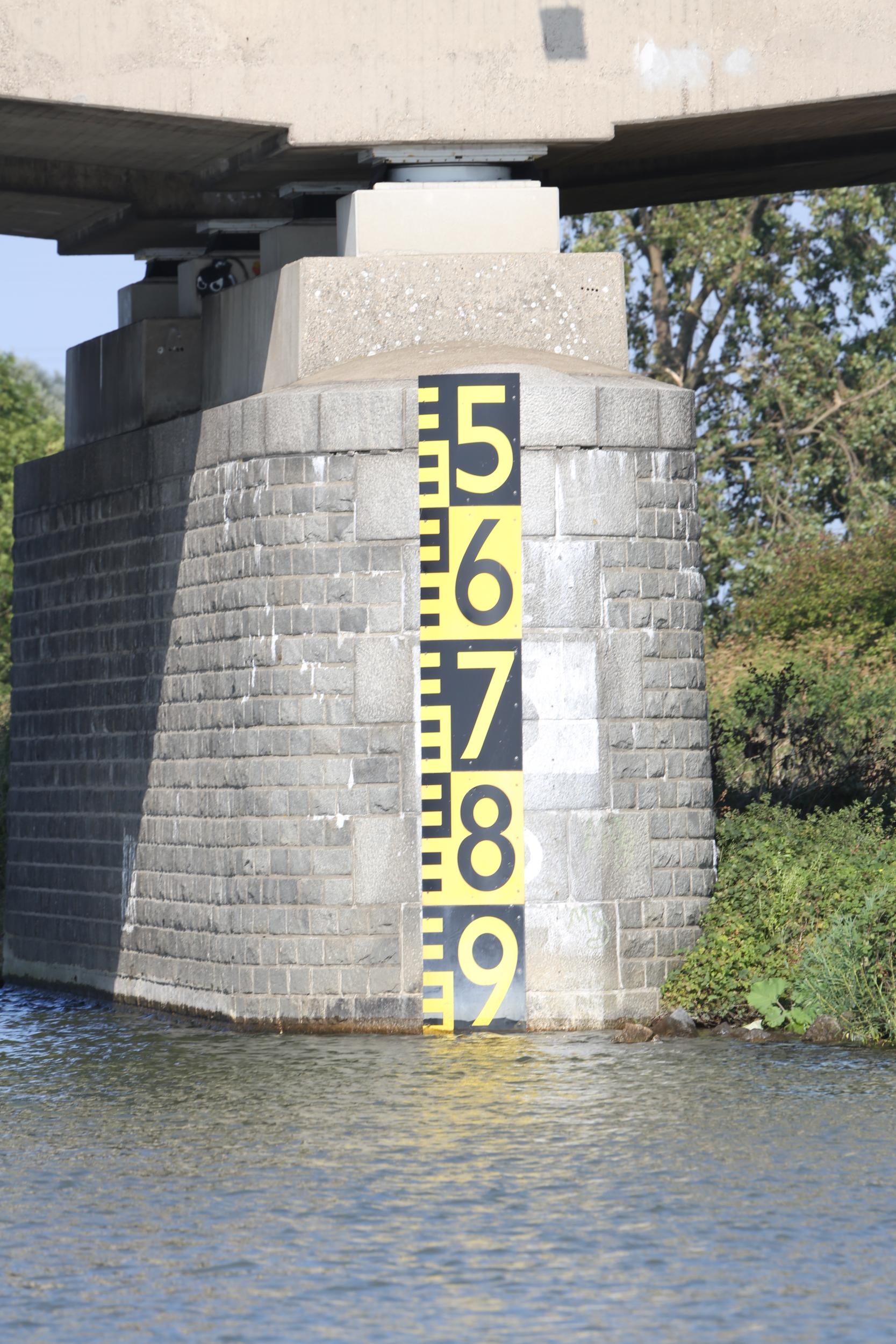
One of the most important things to consider when navigating this route is the air draft of your vessel. Make sure your boat's air draft is compatible with the lowest clearances on the waterways.
Right now, the waterway with the lowest clearance is the Beemsterringvaart:
⚠️ Warning: Lowest air draft is 2.52 m (252 cm / 25.2 dm)!
⚠️ Waarschuwing: Laagste doorvaarthoogte is 2.52 m (252 cm / 25.2 dm)!
⚠️ Achtung: Niedrigste Durchfahrtshöhe beträgt 2,52 m (252 cm / 25,2 dm)!
⚠️ Attention: La hauteur libre minimale est de 2,52 m (252 cm / 25,2 dm)!
⚠️ Attenzione: L'altezza minima di passaggio è di 2,52 m (252 cm / 25,2 dm)!
Pro Tip: You can bypass this part, by continuing on the Noordhollandsch Kanaal from Spijkerboor to Purmerend.
Detailed sections of the Route
More details about this route
Main Sections of the route in detail
After this section, you will find the route sections split into individual waterways. And you will notice, that a single waterway can have multiple names (sections) at the same time. You can use the sections to plan your trip, because they are split into waterway sections that also show mooring places and/or marina's in that section of waterway. Each waterway will also show you how much time navigating this waterway will take.
The sections will give you information regarding the objects on this section like Bridges, Locks (slueuses) and other objects.
Please check the information regarding objects like bridges and locks, because this might be subject of change!
The route and it's sections are build as follows:
First we introduce the section, then we show the global information about that waterway and then give
the details about the objects. (if there are any)
Radio, Calls and AIS
VHF SetStandard Horizon GX1400GPS/E (DSC/GPS)CallsignPD9085Navigation AIS SetOnwa KP-27X (Depth/AIS/GPS)MMSI244170678Working Ch.IJsselmeer calling: Ch 1
Inland calling: Ch 10
Distress: Ch 16
Bridges/locks often 18/20/22TipCall early; have boat name & location ready. Keep Alkmaar, Purmerend, Edam phone numbers at hand.
Remarks
Objects/VHF details per leg are indicative; always check current notices to skippers and operating hours before departure.
Working Ch.IJsselmeer calling: Ch 1
Inland calling: Ch 10
Distress: Ch 16
Bridges/locks often use Ch. 18/20/22TipCall early; have boat name & location ready. Keep Marifoon and phone numbers at hand.
Andijk to Medemblik over the IJsselmeer
Section 1
Traversing The IJsselmeer from Andijk to Medemblik
To get from Andijk, to Medemblik, you have to traverse the IJsselmeer. It is not a very long journey, but it requires some careful navigation on compass.
IJsselmeer Navigation requires at least the 1800 series maps!
To navigate the IJsselmeer, you need to have at least the 1800 series maps. These maps provide detailed information about the waterway, including depth, navigational aids, and potential hazards. It is required to have these maps on board to ensure a safe and successful passage across the IJsselmeer.
When exiting the marina at Andijk, turn starboard until you have a compass course of 309°. After about 2.9 nm, or 5.4 km, you will see the entrance of the Medemblik outer harbour on your port side. The entrance is marked by Green light on the north shore, and Red light on the south shore. It is a short stretch, so it will be around 30 to 45 minutes of navigation, depending on the weather conditions and cruising speed.
Passage Andijk → Medemblik Summary
Total Distance9 kmCompass Course309°ETA (hh:mm)00:45NoteIJsselmeer coastal leg
fairway buoys
Andijk marina/outer harbour approach to Medemblik outer harbour;
VHF 9, tel. +31 227 541 273
Verify opening hours & channels in ANWB Waterkaarten / Vaarweginformatie before departure.
Passing through Medemblik
Section 2
Passing trough Medemblik
Passing Medemblik, several objects will be on your route. Including passing under the railway bridge of the steam-train "Hoorn-Medemblik", part of the "Golden Triangle". In Medemblik you will find several marina's restaurants, shops, but also nautical companies providing services.
The route section trough Medemblik
Passing trough Medemblik, you will pass the objects:
Westfriesche Vaart
Section 3
Using the Westfriesche Vaart
Navigating the Westfriesche Vaart is not difficult. From Medemblik (Overlekersluis) follow the canal to the intersection, here you make a left turn. After that, you'll pass underneath the Highway A7. From there, you will end up in Middenmeer, where you make a left turn towards Kolhorn.
Pro Tip: You should get your provisions at Middenmeer because there is only a very limited shop available at Kolhorn with only the very basic amenities.
The route section along the Westfriesche Vaart
Navigating the Westfriesche Vaart, you will pass the objects:
Kolhornerdiep
Section 4
Cruising the Kolhornerdiep
Navigating the Kolhornerdiep is not difficult. From the Westfriesche Sluis follow the canal westward, passing the intersection with the Waardkanaal and Groetkanaal. Then the safetylock at the Avia Fuel Storage tanks. This lock should always be open. Then you reach the intersection with the Kanaal Alkmaar-Kolhorn.
Caution: The Kolhornerdiep looks wide, but is very shallow outside of the fairway (buoys). It is recommended to stay within the buoys, especially when you have a deeper draft.
Pro Tips: You should get your provisions at Middenmeer because there is only a very limited shop available at Kolhorn with only the very basic amenities. There is a bunkerstation available at Kolhorn.
Stop Tip: Kolhorn is a very nice historic town, worth visiting. We suggest stopping here for a visit!
The route section along the Kolhornerdiep
Navigating the Kolhornerdiep, you will pass the objects:
Kanaal Alkmaar-Kolhorn
Section 5
Cruising the Kanaal Alkmaar-Kolhorn
Navigating the Kanaal Alkmaar-Kolhorn is not difficult. From the Kolhornerdiep, turn southward into the canal and follow the canal southward.
However this canal is also known as the Kanaal Omval-Kolhorn. And while it is known as that name, it is also using the KM sections of the Kanaal Omval-Kolhorn. So, from here, until the Noord-Hollands Kanaal, you will be following the KM sections of the Kanaal Omval-Kolhorn, which is a bit confusing. But just follow the buoys and you will be fine. will see the "section" names (or A.K.A's) of the Kanaal Omval-Kolhorn, but you are actually cruising the sections of the Kanaal Omval-Kolhorn.
Pro Tips: You should get your provisions at Middenmeer because there is only a very limited shop available at Kolhorn with only the very basic amenities. There is a bunkerstation available at Kolhorn.
Stop Tip: Kolhorn is a very nice historic town, worth visiting. We suggest stopping here for a visit!
The route section along the Kanaal Alkmaar-Kolhorn
Navigating the Kanaal Alkmaar-Kolhorn, you will pass the objects:
Niedorpervaart
Section 6
Cruising the Niedorpervaart
Navigating the Niedorpervaart is not difficult. From the Kanaal Alkmaar-Kolhorn, keep following the fairway that is now pointing south-westwards. Here at the intersection with the Niedorpervaart, you will find also a nice marina: Jachthaven De Rijd.
Pro Tips: You should get your provisions at Middenmeer because there is only a very limited shop available at Kolhorn with only the very basic amenities. There is a bunkerstation available at Kolhorn.
Stop Tip: Kolhorn is a very nice historic town, worth visiting. We suggest stopping here for a visit!
The route section along the Niedorpervaart
Navigating the Niedorpervaart, you will pass the objects:
Kanaal Omval-Kolhorn
Section 7
Cruising the Kanaal Omval-Kolhorn
Navigating the Kanaal Omval-Kolhorn is not difficult. From the Niedorpervaart, keep following the fairway that is now pointing southwards. Here after the lock passing the intersection with the Niedorpervaart, you will find also a marina: Hoogeboom watersport (Roskamhaven).
Pro Tips: You should get your provisions here, because there is an ALDI at walking-distance.
The route section along the Kanaal Omval-Kolhorn
Navigating the Kanaal Omval-Kolhorn, you will pass the objects:
Kanaal Alkmaar-Kolhorn
Section 8
Cruising the Kanaal Alkmaar-Kolhorn
Navigating the Kanaal Alkmaar-Kolhorn is not difficult. From the Kanaal Omval-Kolhorn, keep following the fairway that is now pointing southwards.
Pro Tips: You should get your provisions here, because there is an ALDI at walking-distance.
The route section along the Kanaal Alkmaar-Kolhorn
Navigating the Kanaal Alkmaar-Kolhorn, you will pass the objects:
Schermerringvaart
Section 9
Cruising the Schermerringvaart
Navigating the Schermerringvaart is not difficult. From the Kanaal Alkmaar-Kolhorn, keep following the fairway that is now pointing southwards.
Pro Tips: You should get your provisions here.
This intersection, gives you also the opportunity to use the "Hoornse Vaart" to get into the City, where you are next to the supermarkets and shopping streets.
The route section along the Schermerringvaart
Navigating the Schermerringvaart, you will pass the objects:
Noordhollandsch Kanaal
Section 10
Cruising the Noordhollandsch Kanaal
Navigating the Noordhollandsch Kanaal is not difficult. From the Schermerringvaart, keep following the fairway that is now (still) pointing southwards. This section does not have many objects.
Pro Tips: You should get your provisions here in Alkmaar.
This intersection, gives you also the opportunity to use the "northern" section of the Noordhollandsch Kanaal to get into the City, where you are next to the supermarkets and shopping streets.
Stop Tips: A nice place to stop is the marina Jachthaven 't Hoorntje. This is a small marina, but it has a nice restaurant and is close to the city center. If you want to stay in the city center, there are also some mooring places along the canal, but make sure to stop at the designated mooring points along the way. By the way, this is the former harbor of the Parel!
The route section along the Noordhollandsch Kanaal
Navigating the Noordhollandsch Kanaal, you will pass the objects:
Beemsterringvaart
Section 11
Cruising the Beemsterringvaart
Navigating the Beemsterringvaart is not difficult. From the Noordhollandsch Kanaal, keep following the fairway that is now (still) pointing northwards. This section does not have many objects. Be careful! The bridges on this section are pretty low, so make sure to check the clearance before you go under them. The Beemsterringvaart is not suitable for boats with a high mast.
Pro Tips: You should get your provisions here in Alkmaar.
This intersection, gives you also the opportunity to use the "northern" section of the Beemsterringvaart to get into the City, where you are next to the supermarkets and shopping streets.
Stop Tips: A nice place to stop is the marina Jachthaven 't Hoorntje. This is a small marina, but it has a nice restaurant and is close to the city center. If you want to stay in the city center, there are also some mooring places along the canal, but make sure to stop at the designated mooring points along the way. By the way, this is the former harbor of the Parel!
The route section along the Beemsterringvaart
Navigating the Beemsterringvaart, you will pass the objects:
De Where
Section 12
Cruising de Where
Navigating De Where is not difficult. From the Beemsterringvaart, make a left turn into De Where. Here, you can also moor for the night at W.S.V. Purmerend.
Pro Tips: You should get your provisions here in Purmerend.
This intersection, gives you also the opportunity to use the "northern" section of the Beemsterringvaart to get into the City, where you are next to the supermarkets and shopping streets.
Stop Tips: A nice place to stop is the marina Jachthaven 't Hoorntje. This is a small marina, but it has a nice restaurant and is close to the city center. If you want to stay in the city center, there are also some mooring places along the canal, but make sure to stop at the designated mooring points along the way. By the way, this is the former harbor of the Parel!
The route section along De Where
Navigating de Where, you will pass the objects:
Vaart van Edam naar Purmerend
Section 13
Cruising the Vaart van Edam naar Purmerend
Navigating Vaart van Edam naar Purmerend is not difficult. From de Where, make a left turn into Vaart van Edam naar Purmerend (AKA: Purmerringvaart).
Pro Tips: You should get your provisions here in Purmerend.
This intersection, gives you also the opportunity to use the "northern" section of the Beemsterringvaart to get into the City, where you are next to the supermarkets and shopping streets.
Stop Tips: A nice place to stop is the marina Jachthaven 't Hoorntje. This is a small marina, but it has a nice restaurant and is close to the city center. If you want to stay in the city center, there are also some mooring places along the canal, but make sure to stop at the designated mooring points along the way. By the way, this is the former harbor of the Parel!
The route section along the Purmerringvaart
Navigating the Vaart van Edam naar Purmerend, you will pass the objects:
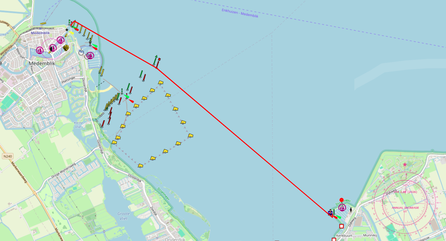
Markermeer: Edam to Enkhuizen
Section 13
Navigating the Markermeer
Just like the IJsselmeer, the Markermeer is a large lake, but it is more shallow and has less commercial traffic on the west-side. The route along the Markermeer is quite straightforward, and gives you some options. You can either follow the route along the coast, which is more scenic and gives you some nice views of the lake and the option to visit Hoorn, or you can take the more direct route in a straight line, which is faster but less scenic. The latter is more practical and the better choice to not get stuck in vegetation. And you can always see if there is space available at Wijdenes (Call them first! +31(0)228-565750), or Broekerhaven.
The Krabbersgatsluis is only used by commercial vessels, so you don't have to worry about closing it. However, always keep an eye out for commercial vessels and give them way. The Naviduct is used by both commercial and pleasure boats, so you don't have to worry about closing it.
Pro Tips: The following are important:
- Keep an eye on the weather, as the Markermeer can get quite rough in bad weather.
- Make sure to have enough fuel, as there are no refueling options along the route (in the middle of the lake).
- Be aware of the traffic, especially during the summer months when the lake is busy with recreational boats.
- Be cautious of the wind conditions, as they can significantly affect your navigation and safety.
- Consider vegetation, which can cause your propeller to get entangled. Specifically right under the
coastline.
Download the "waterplanten.nu" app
The route section over the Markermeer
Visiting Enkhuizen
Enkhuizen is a beautiful historic city with a rich maritime heritage. It has several museums, including the Zuiderzee Museum, which offers a glimpse into the history of the former Zuiderzee and its impact on the region.
Source map: Waterkaart.net
You can leave your boat at one of the marinas in Enkhuizen, of which the majority are directly connected to the old town and give the option to visit a number of museums, restaurants, shops, and other amenities, all within walking distance of the marina.
IJsselmeer: Enkhuizen to Andijk
Section 13
Navigating the IJsselmeer
Source map: Waterkaart.net
Passing the Naviduct is uneventful when you pay attention to the instructions given by the Lock Master. Rules are: Commercial goes first, and you follow. Make sure you leave some room between you and the commercial vessel. Be aware of the propeller wash of large vessels, which can cause your boat to pitch and roll. If you just keep calm, you'll pass over the naviduct without any issues, entering the IJsselmeer.
The route along the IJsselmeer is quite straightforward, and gives you some options. You can either follow the route along the coast, or use the "straigt lines" navigation. Following the green KG buoys gives you the most scenic and direct route. However, after leaving the Krabbersgat, you can also set course to bouy EZ-B, and then head towards buoy SPORT D, and then keep the chimney of the Steam-Engine Museum as your target (course 271°) until you see the Andijk Marina on your port side. Then use course 205° to get to the entrance of the marina.
Pro Tips: The following are important:
- Keep an eye on the weather, as the IJsselmeer can get quite rough in bad weather.
- Be aware of the traffic, especially during the summer months when the lake is busy with recreational boats.
- Be cautious of the wind conditions, as they can significantly affect your navigation and safety.
- Consider vegetation, which can cause your propeller to get entangled, (although this is not as bad as it is on the Markermeer)
specifically: in the corners of the lake, near the coastline.
Download the "waterplanten.nu" app
The route section over the IJsselmeer
Support the KNRM!
Help them to help others!
I would like to ask you to become a donor for the KNRM.
The KNRM is a fully private organisation, completely run by volunteers, financed by contributions and donations. You will find all information about them on the website.
You can choose from a single one time payment or a monthly or yearly donation. Please Support them.
Our personal opinion is that every person out on the water should, by law be told to make a donation of €25,- per year. But that is just our opinion.
Copyright, Disclaimer & Attribution
The legal stuff needed because of stupid....
The content on this website may include materials such as text, images, videos, and other media that are the property of their respective owners. All trademarks, logos, and copyrighted works remain the intellectual property of their original creators.
We strive to properly attribute and acknowledge all sources. If you are the copyright owner of any material featured on this site and believe it has been used without appropriate credit or permission, please contact us at [your contact email] so we can promptly address the issue.
Where applicable, the use of third-party content falls under fair use, creative commons licenses, or other applicable legal provisions. If specific attribution is required, it is provided directly alongside the respective material.
The images and data on this site are NOT intended for navigation or critical decision-making. Any reliance on this information is strictly at your own risk. The information on this site is for PERSONAL USE ONLY. You may print or copy parts of it for your own private use. Commercial use is strictly FORBIDDEN. Do not sell, rent, or use this data for profit. Unauthorized commercial exploitation will be met with rigorous legal action to the fullest extent of the law Furthermore, automated data scraping, harvesting, or feeding this content into large language models or AI systems is strictly PROHIBITED. If automated tools crawl this site without express written permission, access will be blocked, and those responsible will be held liable for unauthorized bandwidth usage and intellectual property infringement.
Powered by Haringstad
Build with VIM
© Haringstad, J and S van Koll