One of the more interesting trips to undertake is a round trip journey from the Netherlands into Germany and back.
While parts of this route may already look familiar from earlier
trips or vlogs
Route vlogs made by the Canicula and others show parts of this route, but not the entire route from Andijk to Haren.
But they do show the trip from Meppel to Haren.
, the number of inland (fresh)waterway connections into Germany is actually quite limited.
In fact, for north-western Germany, there is only a single true inland entry point:
the Haren–Rütenbrock Canal (Haren–Ruitenbroekkanaal).
This canal connects the Dutch Stads-Compascuum canal (between Barnflair and Munnikemoer) with
Haren 🇩🇪 (Ems) in Germany.
The
Haren–Rütenbrock Canal is approximately 14 km long
and forms a direct link between the Dutch inland waterway system and the German waterways network. Once you pass this canal, you
enter the Dortmund–Ems Canal, connecting to a vast range of cruising possibilities within Germany, or even beyond!
Because of these adventurous options, these routes towards Haren are about
how you get to that single crossing point.
Eastbound routes toward Haren (Ems) 🇩🇪
When departing from North Holland or the IJsselmeer/Markermeer/Randmeren area(s), there are multiple ways to reach
the north-eastern part of the Netherlands. Regardless of your chosen route, they all share one simple truth:
All routes eventually converge near Barnflair and Ter Apel, where you cross the border into Northern Germany.
The concept in short
Choose your route based on preference: wide and predictable waterways, or smaller and more
scenic canals. Once you reach the Groningen / Veenkoloniën region, the waterways naturally
guide you eastward toward Ter Apel and the German border.
Route option 1: Via Meppel
Meppel is a classic inland junction and offers two distinctly different
eastbound routes:
Option 1A leads you almost straight eastward through Hoogeveen and Klazienaveen
before reaching Ter Apel and Barnflair.
This route is generally quieter and more intimate, but requires more preparation.
Certain sections, particularly around Klazienaveen, may have
restrictions or limited bridge operations. Skipper's note: Ideal if you prefer calm waterways and fewer commercial vessels,
but always verify current navigability.
Option 1B takes you from Meppel north through Assen and Groningen before heading east to Ter Apel. This
route takes you over the Drentsche Hoofdvaart towards Assen.
This is a busy, not too wide but well-maintained canal,
which can be (very) busy with pleasure vessels.
After Assen, you continue north to Groningen before heading east toward Ter Apel.
This route is less direct and generally has better infrastructure,
but it can be busier and a little less scenic than the southern alternative. Skipper's note: Best if you prefer a more straightforward route with fewer navigational challenges,
but be prepared for potential traffic of pleasure craft.
Route option 2: Via Friesland (Lemmer or Stavoren)
This route will be covered in a different section.
Lemmer (via Prinses Margrietkanaal) is the most straightforward gateway
into the Northern Dutch inland waterways.
From here, you enter the Prinses Margrietkanaal, the main east–west shipping
route through Friesland. This canal is wide, well-maintained, and used by both commercial traffic and recreational vessels.
Note: Do use the large locks on the north side. The use of these locks is free of charge. When you decide
to pass through the old city lock and center, you pay at least +€10,- to the Frisian Bridge and Lock Maffia to pass
all objects in Lemmer until you reach the Prinses Margrietkanaal.
Stavoren (via Prinses Margrietkanaal) is an equally viable entry point,
although it requires slightly more inland navigation before joining the Prinses Margrietkanaal.
From within Friesland, you continue toward Groningen via the
Van Starkenborghkanaal and Eemskanaal. After passing Groningen,
the route naturally leads into the Veenkoloniën area and onward to Ter Apel.
Skipper's note: This is the "big water" option — predictable bridge operations,
reliable depths, and straightforward daily planning. It will be covered in a different section.
Final leg: Barnflair 🇳🇱 → Haren (Ems) 🇩🇪
Close to Ter Apel, actually Barnflair, all routes converge. At the intersection of the canals,
you follow the HRK eastward across the border via the
Rütenbrock connection, which leads directly to
Haren (Ems) 🇩🇪 and the German inland waterway network.
Bottom line: Different approaches, but still a single entry point. Choose the kanals in Friesland and Groningen
for ease and predictability, or Meppel for character and quieter waters — either way, Barnflair is the inland doorway into Germany.
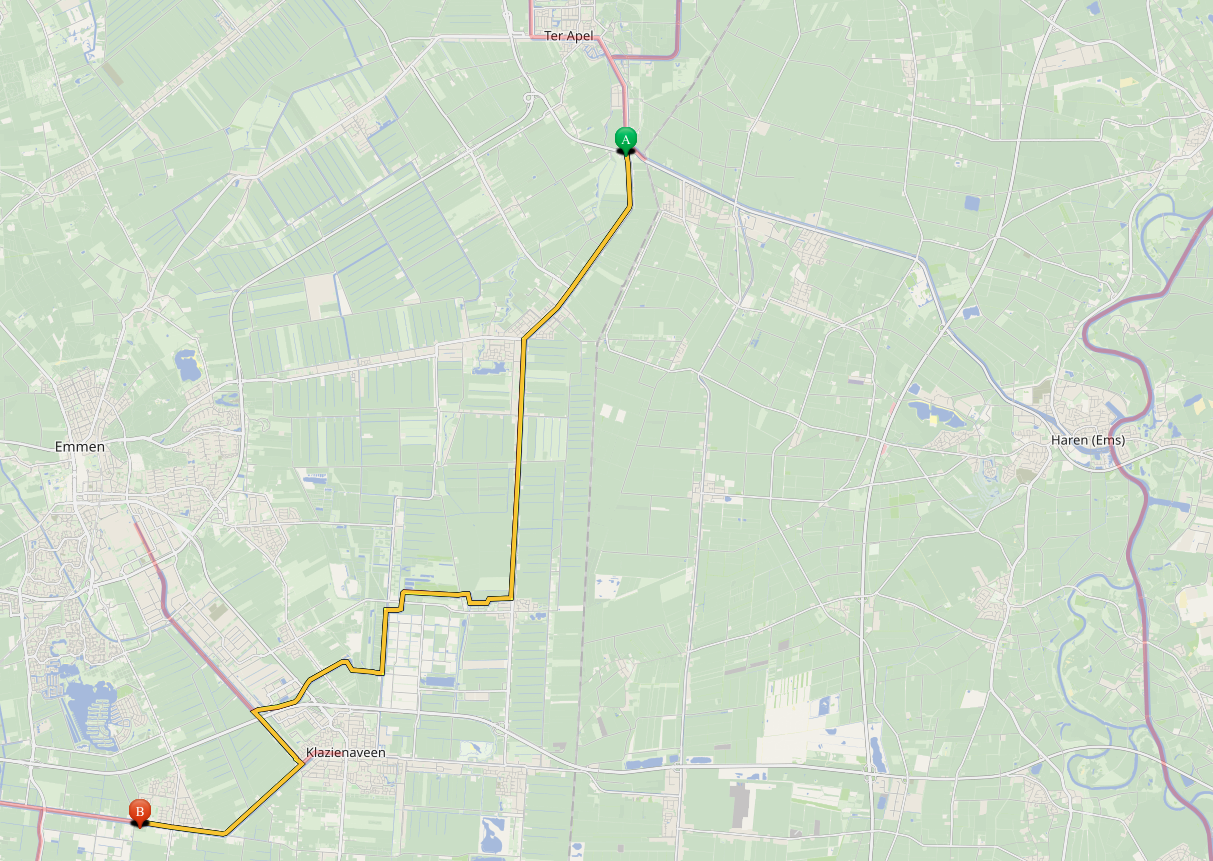
We already determined that there are 3 major routes towards Barnflair 🇳🇱 and subsequently to Haren (Ems) 🇩🇪 and our choice is to follow the most scenic route, AKA Route 1A.
Option 1A leads you almost straight eastward through Meppel, Hoogeveen and Klazienaveen before reaching Ter Apel and Barnflair.
This route is generally quieter and more intimate, but requires more preparation. Certain sections, particularly around Klazienaveen, may have restrictions or limited bridge operations.
However, this is our preferred route. Skipper's note: Ideal if you prefer calm waterways and fewer commercial vessels, but always verify current navigability.
⚠️ Warning: Lowest air draft is 3.50 m (350 cm / 35.0 dm)!
⚠️ Waarschuwing: Laagste doorvaarthoogte is 3.50 m (350 cm / 35.0 dm)!
⚠️ Achtung: Niedrigste Durchfahrtshöhe beträgt 3,50 m (350 cm / 35,0 dm)!
⚠️ Attention : La hauteur libre minimale est de 3,50 m (350 cm / 35,0 dm)!
While the other route options may differ in terms of scenery, traffic, and navigational complexity, all ultimately lead to the same destination:
Barnflair, the gateway to Germany. The choice between them depends on your preferences for scenery, traffic, and navigational challenges.
Skipper's note: We will be taking Option 1A, as it offers a good balance of tranquility and navigational ease, while also allowing us to
experience the diverse landscapes of the Netherlands before crossing into Germany.
Menu: Travel options to Barnflair and Haren (Ems) 🇩🇪
Back
Andijk to Urk 🇳🇱
24 Januari 2026
Crossing the IJsselmeer 🇳🇱 to Urk 🇳🇱
Fig. 3 – Urk Vlag (Urk Flag)
Departing Andijk, having decided that taking route 1A to Barnflair 🇳🇱 and subsequently to Haren (Ems) 🇩🇪 is the goal.
To reach Meppel, the intersection for routes 1A/1B, we will first need to cross the IJsselmeer from Andijk to Urk.
This is a significant crossing, as the IJsselmeer is a large lake with potentially challenging conditions. We will need
to carefully plan our departure time to ensure favorable weather and water conditions for the crossing.
Skipper's note: Crossing the IJsselmeer can be, if you aren't carefull, a daunting task,
especially for those unfamiliar with its conditions. It is crucial to check the weather forecast, wind direction, and wave
heights before setting off. We will also ensure that we have all necessary safety equipment on board and that our boat is in
good condition for the crossing.
Once we successfully cross the IJsselmeer and reach Urk, we will be well on our way to Meppel and the rest of our journey toward Haren (Ems) 🇩🇪.
Navigational details Andijk to Urk
Vid.1 - Andijk to Urk
The crossing from Andijk to Urk is approximately 20 nautical miles (35 km) across the IJsselmeer. The route is straightforward,
but it requires navigation and attention to weather conditions.
We will depart from Andijk and head southeast across the IJsselmeer, aiming for the harbor of Urk. The route will take us through
open water, so we will need to be vigilant for any changes in weather or water conditions.
Skipper's note: It is advisable to have a backup plan in case the weather conditions become unfavorable during the crossing.
Monitor the weather closely and be prepared to seek shelter if necessary.
The route section over the IJsselmeer
Course and waypoints
Here are the key waypoints and course details for crossing the IJsselmeer from the piers of
Jachhaven Andijk to the harbor of Urk
These waypoints are based on the planned route and may be subject to change based on
real-time conditions and navigational decisions. You are responsible for your navigation!
Course (°)
Distance (nm)
Coordinates (Lat/Long)
Description
183.22°
0.05 nm
N 52°44'41" - E 5°10'48"
Turning Point Harbor exit
276.55°
0.08 nm
N 52°44'41" - E 5°10'39"
Turning Point 2 Harbor exit
17.8°
0.86 nm
N 52°45'30" - E 5°11'05"
Turning Point 3 Open water
90°
4.19 nm
N 52°45'30" - E 5°18'00"
Bol Sport D Wagenpad
123.4°
8.65 nm
N 52°40'44" - E 5°29'55"
EZ-D
121°
3.40 nm
N 52°38'59" - E 5°34'44"
Buoys leading to Urk
74°
0.80 nm
N 52°39'13" - E 5°36'00"
Buoys leading to Urk
347.2°
0.17 nm
N 52°39'23" - E 5°35'56"
Buoys leading to Urk
Download Route Waypoints Andijk-Urk
You can download the waypoints for this route in
GPX
GPS Exchange Format — the standard open format for storing GPS waypoints, routes, and tracks.
Compatible with most chart plotters, navigation apps, and dedicated GPS devices.
, CSV and
ODF (Onwa)
Onwa proprietary route format for Onwa chart plotters. ODF files can be loaded directly
into Onwa MFD devices for turn-by-turn navigation.
format using the links below:
Urk is a charming fishing village with a rich maritime history. It offers a variety of amenities for boaters, including a marina, shops, and restaurants.
It is a great place to rest and resupply before continuing on the journey towards Meppel and eventually Haren (Ems) 🇩🇪.
Skipper's note: Take some time to explore Urk and enjoy the local culture and cuisine. It's a great opportunity to experience a
traditional Dutch fishing village before heading inland towards Germany.
Pro Tip: During the summer season, the harbor is particularly busy with visitors and local activities. Make sure you are on
time to secure a spot at the harbor.
Nearby Services - Port of Urk (Haven Urk)
Closest Supermarket (Harbor): Boni Supermarkt Location: 't Klif 3, 8321 KG Urk
Distance: Directly behind the harbor dike (approx. 2-minute walk)
Best for: General groceries, fresh local products, and "Kroeb" horse sausage (a local specialty).
Nearest Bakery: Bakkerij Brouwer (Oude Dorp) Location: Wijk 7-30, 8321 VL Urk
Distance: Approx. 400 meters (5-minute walk)
Best for: Freshly baked bread and traditional "Urker dikkoek". Located in the historic town center.
Largest Supermarket Area: Winkelcentrum Urkerhard Location: Nagel 60, 8321 RG Urk
Distance: Approx. 2 km (5-minute drive / 20-minute walk)
Best for: Large-scale shopping with multiple supermarkets (Jumbo, ALDI) and various retail shops in one location.
Nearest Gas Station: Tankstation Westwal Location: Westwal 1, 8321 WG Urk
Distance: Directly adjacent to the harbor area
Service: Providing Diesel (Gazole) and Euro 95.
Note: Very convenient for boaters; they also offer fresh sandwiches and snacks at the shop.
Leaving Urk
Urk is located at the IJsselmeer, making it a strategic point for continuing the journey towards Meppel and eventually Haren (Ems) 🇩🇪.
From Urk, there are two different routes to reach Meppel, which is the next major waypoint on our journey. The choice of route will depend
on our preferences for scenery, traffic, weather and navigational challenges.
There are two different routes available:
Direct route through the IJsselmeer and Ketelmeer to Meppel
Alternative route via the canals, passing Emmeloord and the Zwarte Water to Meppel
What is the weather doing? The IJsselmeer 🇳🇱 or Canals 🇳🇱
Fig. 3 – Flevoland Vlag (Flevoland Flag)
Departing Urk depends on the weather conditions, because the next leg of the journey involves crossing another part of the IJsselmeer,
which can be challenging in unfavorable weather. Specifically at the Ketelbrug, it might be challenging. If the weather is good, we will
take the direct route across the IJsselmeer to Meppel. However, if the weather is not favorable for crossing open water, we will take the
alternative route through the canals, passing Emmeloord and the Zwarte Water to reach Meppel.
Skipper's note: The decision between the direct route across the IJsselmeer and the alternative canal route will
be based on the weather forecast, including wind speed and direction, wave heights, and overall conditions on the IJsselmeer.
The direct route is more efficient but can be rough in bad weather, while the canal route offers more shelter and is more predictable,
albeit longer in time.
Whenever the weather is not favorable for crossing the IJsselmeer, we will take the canals route from Urk to Meppel.
This route will take us through a series of canals and waterways, passing through Emmeloord and eventually reaching the
Zwarte Meer before heading towards Meppel.
The canal route is more sheltered and can be more comfortable in bad weather, but it is also longer (in time) and requires more
navigation through locks and narrow passages.
Vid.2 - Urk to Emmeloord and the Zwarte Meer
Skipper's note: When taking the canal route, it is important to be prepared for navigating through
locks and narrow passages. Make sure to check the lock schedules and be patient, as there may be delays. Also, be aware of the
traffic on the canals, as they can be busy with both commercial and recreational boaters.
Pro Tip: When navigating through the canals, it is advisable to have a good understanding of the lock operations
and to communicate effectively with lock operators and other boaters. Always follow the rules of the canals and be cautious when
passing through narrow sections, as they can be challenging to navigate, especially in adverse weather conditions.
Waterways, Objects, Course and waypoints for the canal route
Here are the key waterways, waypoints and course details for the canal route from Urk to Meppel:
Urk - Emmeloord
The first leg of the canal route takes you from Urk to Emmeloord. This section will take you through the Urkervaart, which is a canal that connects Urk to the
larger waterway network in Flevoland. Along this route, you will pass through several objects and navigate through narrower sections of the canal.
The canals you are navigating, have been created while there was still the water of the IJsselmeer above what now is
the Noordoostpolder. The canals are quite straight, and the water is quite deep, which makes it very nice to navigate.
And it is a big feat how this was done in the 1930s, with the technology of that time. The canals are still in good condition, and they are well-maintained,
which makes for a pleasant boating experience.
By stopping at the Quay at Emmeloord, you can get groceries right across the street!
The route section on the Urkervaart
On the Urkervaart, you will pass the objects:
Stay at Emmeloord?
Emmeloord is the main town in the Noordoostpolder and offers a variety of amenities for boaters, including a marina, shops, and restaurants.
It is a great place to rest and resupply before continuing on the journey towards Meppel.
Skipper's note: Take some time to explore Emmeloord and enjoy the local culture and cuisine. It's a great opportunity to experience a
town in the heart of the polder before heading deeper inland towards Germany.
Pro Tip: During the summer season, the harbor is particularly busy with visitors and local activities. Make sure you are on
time to secure a spot at the harbor.
Closest Supermarket: Jumbo Odink Location: Europalaan 33, 8303 GH Emmeloord
Distance: Approx. 500 meters (6-minute walk)
Best for: Large assortment, fresh produce, and long opening hours.
Nearest Bakery: Bakker Bart (Center) Location: Lange Nering 44, 8302 ED Emmeloord
Distance: Approx. 350 meters (4-minute walk)
Best for: Freshly baked bread, warm snacks, and lunch options directly in the main shopping street.
Alternative Supermarket: ALDI Emmeloord Location: Lange Nering 83, 8302 EB Emmeloord
Distance: Approx. 600 meters (7-minute walk)
Best for: Budget-friendly groceries, located right next to the Poldertoren.
Nearest Gas Station: Tamoil Express Location: Industrieweg 6, 8304 AD Emmeloord
Distance: Approx. 850 meters (10-minute walk / 3-minute drive)
Service: 24/7 automated station providing Diesel (Gazole) and Euro 95.
Note: Located in the industrial area "De Munt", which is practical for filling jerrycans near the harbor.
Emmeloord to the Vollenhover kanaal
After your (optional) stay at Emmeloord, you will continue towards the Vollenhover kanaal on the Zwolse Vaart.
Possible waypoints are:
Marina WSV Kraggenburg: A marina located along the Vollenhover kanaal, offering mooring facilities and amenities for boaters.
It's a good place to stop for a break or to explore the surrounding area.
Intersection with Noorderdiep: This is the main waterway towards Meppel. It's an important navigational point where you will need
to make a turn to continue towards Meppel.
In this canal there are minimal objects, so there is only the delay at the lock at Marknesse, before you decide to stop at
Marina WSV Kraggenburg, or continue to the intersection with the Vollenhover Kanaal, which is the main route towards Meppel.
Ergo, following the Zwolse Vaart will be very nice to navigate.
The route section on the Zwolse Vaart
On the Zwolse Vaart, you will pass the objects:
Exiting the Zwolse Vaart
When exiting the Zwolse Vaart, you enter the Vollenhover kanaal. And when you want to stop, you can choose
to dock at Vollenhove. This is approx. 2 kilometers from the intersection, only in the wrong direction.
Note: we do list Vollenhove in the listing below while you enter at the intersection at KM 5.2. To
get to Vollenhove, take a turn to port (North/Left) and after 2 km, the entry to the harbor will be on the right bank
just before the bridge.
To continue on the main route, turn to starboard (South/Right) towards the Kadoelersluis and the Zwarte Meer.
The route section on the Vollenhover kanaal
On the Vollenhover kanaal, you will pass the objects:
Intersection of the routes from Urk
At the intersection of the routes from Urk, you will have the option to continue towards Meppel via the Zwarte Water and Zwartsluis.
Urk to Meppel over the IJsselmeer and Ketelmeer 🇳🇱
24 Januari 2026
Navigational details for the Ketelmeer route 🇳🇱
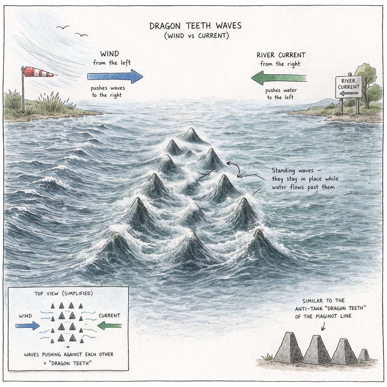
Fig. 5 – Dragonteeth Waves under the Ketelbrug
Departing Urk, head southeast across the IJsselmeer, aiming for the Ketelbrug, approximately 3.2 nautical miles (6 km) distance from the harbor.
The route will take us through open water, so we will need to be vigilant for any changes in weather or water conditions.
Specifically West and South-west winds can create challenging swells and waves in this area.
Skipper's note: It is advisable to have a backup plan in case the weather conditions become unfavorable during the crossing.
Monitor the weather closely and be prepared to seek shelter if necessary. Also, be aware of
"Dragonteeth" waves
Pointy, static waves created by wind and river current running against each other. They form
steep, unpredictable waves in narrow passages like under the Ketelbrug — particularly
challenging for smaller vessels.
underneath the Ketelbrug.
Pro Tip: If you encounter dragonteeth waves under the Ketelbrug, it is advisable to modify speed and maintain a steady course.
Avoid sudden maneuvers, and if possible, wait for the waves to subside before proceeding. If the conditions become too challenging, consider seeking shelter
in a nearby harbor or marina until the weather improves. Always prioritize safety when navigating through areas known for dragonteeth waves, as they can be
unpredictable and dangerous.
Vid.3 - Urk to the Ketelmeer
Course and waypoints IJsselmeer & Ketelmeer
Here are the key waypoints and course details for crossing the IJsselmeer from the piers of the Harbor of Urk to the two approaches over the
Ketelmeer, north or south of IJsseloog to reach the
Ramsdiep and/or Ramsgeul
These waypoints are based on navigational objects like buoys, landmarks,
and navigational aids that are commonly used by boaters to navigate the
route over the IJsselmeer and Ketelmeer from Urk towards the Zwarte Meer.
They are intended to provide guidance and reference points for navigation,
but it is important to always use up-to-date charts and navigation tools
when planning and executing a route!
There are two routes over the Ketelmeer, both with their own set of waypoints. In the next sections we will describe both routes.
First the route takes you over the IJsselmeer to the Ketelbrug. After the Ketelbrug you have to be carefull because of the powerline
masts that are positioned on the Ketelmeer. The intersection of the two routes is at N 52°36'13" - E 5°39'33". For reference:
The southern route over the Ketelmeer is called the "Hanzerak".
Ketelmeer routes: North or South
Routes North or South of IJsseloog
Vid.4a - Ketelmeer to Zwarte Meer NorthVid.4b - Ketelmeer to Zwarte Meer South
Overview of the Ketelmeer
The Ketelmeer is a shallow inland artificial lake in the Netherlands, located in the province of Flevoland.
It is the eastern part of the IJsselmeer, connected by the Ketelbrug bridge. The lake is a popular destination for
recreational boating, fishing, and birdwatching, and is known for its diverse flora and fauna.
The Ketelmeer is also an important ecological area, providing habitat for various bird species and aquatic life.
In the middle of the Ketelmeer there is an artificial island, called IJsseloog. This island is used for the storage of
contaminated river sludge from France, Belgium, and Germany that entered the Netherlands as sediment carried by water of the streams
of the rivers Rhine and Meuse. All countries connected by those rivers, have contributed to the
contamination.
All countries connected to these rivers have in the past discharged large quantities of all kinds of toxic waste,
which ended up in the Netherlands carried by the flow of these rivers and settled in the silt of the delta.
Furthermore, because canals and ditches have been filled (and are still being filled), it has ended up there as well.
The Netherlands must therefore clean up the mess left by the surrounding countries.
North or South around IJsseloog
There are two ways around the IJsseloog: north or south of it. The south means you are taking the Hanzerak.
The northern route is the preferred one to take to get to the Ramsdiep and Ramsgeul. It is a bit shorter
than the southern route and there are generally less other boats on that route. The "intersection" is at
N 52°36'13" - E 5°39'33", where the two routes meet (or split, depending on your starting point). From there you
choose one of the two fairways that goes around the IJsseloog.
When you are at the "intersection" on the Ketelmeer, this only implies that there are 2 fairways to pass the
IJsseloog
The artificial island in the center of the Ketelmeer, built to store contaminated river sludge
transported from France, Belgium, and Germany via the Meuse and Rhine rivers.
:
North: the northern fairway, heading almost straight towards the Ramsdiep/Ramsgeul.
South: the southern fairway, heading towards the mouth of the IJssel, or the connecting canals in Northern-Flevoland. This takes
you along the south side of the IJsseloog. But this might benefit when the winds are unfavorable.
Course and waypoints Ketelmeer to Zwarte Meer
After crossing the Ketelbrug and entering the Ketelmeer, the following waypoints3 are for each sub-route toward the Zwarte Meer.
The key waypoint is the entrance to the
Ramsdiep
The commercial shipping lane connecting the Ketelmeer to the Zwarte Meer, crossing the Balgstuw.
Primarily used by larger freight vessels.
and Ketelhaven. The Ramsdiep is the commercial shipping lane that connects the Ketelmeer
to the Zwarte Meer. At this waypoint you can also choose to take the
Ramsgeul
The pleasure-craft lane running parallel to the Ramsdiep, also crossing the Balgstuw.
Quieter and more scenic than the commercial Ramsdiep.
, which is the pleasure shipping lane that also connects the
Ketelmeer to the Zwarte Meer. Both routes will lead you to the intersection at the bird sanctuary in the Zwarte Meer where the Zwarte Water
meets the Zwarte Meer, continuing the main route towards Zwartsluis and Meppel.
Routes on the Ketelmeer
When on the Ketelmeer, you can explore various routes and waypoints that offer scenic views and interesting navigation opportunities.
In the middle of the Ketelmeer is the artificial island of IJsseloog, which is a unique landmark and can be used as a reference point for navigation.
Pro Tip: The Ketelmeer is a popular area for boating and offers several routes that can be explored to get to the Zwarte Meer.
Some of the notable routes include:
Route 1: From the Ketelbrug on the north side of IJsseloog to the entrance of the Ramsdiep
Route 2: From the Ketelbrug on the south side of IJsseloog to the entrance of the Ramsdiep
Route 3: From the Ketelbrug on the north side of IJsseloog to the entrance of the Ramsgeul
Route 4: From the Ketelbrug on the south side of IJsseloog to the entrance of the Ramsgeul
Each route offers a unique perspective on the Ketelmeer and the surrounding area. But all will lead to the Zwarte Meer and the intersection at
the bird sanctuary in the Zwarte Meer where the Zwarte Water meets the Zwarte Meer.
Skipper's note: When navigating the Ketelmeer, it is important to be aware of the traffic and other vessels in the area,
as it can be busy with both commercial and recreational boaters. Always follow navigational rules and be cautious when passing through narrow channels or
areas with heavy traffic.
IJsseloog is the artificial island for contaminated sludge in the center of the Ketelmeer, containing the contaminated material
that was donated to us by France, Belgium, and Germany via mainly the Meuse and Rhine rivers. It's quite something how these countries have
a lot to say about water pollution in the Netherlands today, yet refuse to take any responsibility for the bulk of the mess they sent our way.
The Ramsdiep is the commercial shipping lane connecting the Ketelmeer and the Zwarte Meer crossing the
Balgstuw
A movable flood barrier in the Ketelmeer that regulates water levels between the Ketelmeer
and the Zwarte Meer. Both the Ramsdiep and Ramsgeul pass through it.
.
The Ramsgeul is the pleasure shipping lane connecting the Ketelmeer and the Zwarte Meer crossing the Balgstuw.
Ramsdiep or Ramsgeul?
Both routes are parallel and will lead you to the Zwarte Meer. The Ramsdiep is the commercial shipping lane, which means it is primarily used by larger
vessels and may have more traffic. The Ramsgeul is the pleasure shipping lane, which is typically used by smaller recreational boats and may be less busy.
When choosing between the two routes, consider the following factors:
Traffic: The Ramsdiep may have more commercial traffic, which can be more challenging to navigate, especially for smaller vessels.
The Ramsgeul may be less busy and more suitable for recreational boaters.
Navigation: The Ramsdiep may have more navigational aids and be better maintained for larger vessels, while the Ramsgeul may have
equal aids and be more suitable for smaller boats.
Scenery: Only the Ramsgeul route offer scenic views of the Ketelmeer and the surrounding area where the Ramsgeul may provide a more
peaceful and enjoyable experience while the Ramsdiep is straight and more functional (boring).
Download Route Waypoints Urk - Ketelmeer - Meppel
You can download the waypoints for this route in
GPX
GPS Exchange Format — the standard open format for storing GPS waypoints, routes, and tracks.
Compatible with most chart plotters, navigation apps, and dedicated GPS devices.
, CSV and
ODF (Onwa)
Onwa proprietary route format for Onwa chart plotters. ODF files can be loaded directly
into Onwa MFD devices for turn-by-turn navigation.
format using the links below:
Navigational details for this section of the route 🇳🇱
Fig. 5 – Zwartsluis Vlag (Zwartsluis Flag)
Already on the Zwarte Meer, coming either from the Ramsdiep/Ramsgeul, or the Vollenhover Kanaal, this is where the journey towards Meppel continues.
From the Zwarte Meer, heading 119° Compass, you will enter the Zwarte Water which is a river that flows through the city of Zwolle and eventually
leads along the town of Zwartsluis towards the Zwarte Meer. From Zwartsluis, you can continue on to Meppel via the Meppelerdiep.
Skipper's note: When taking the canal route, it is important to be prepared for navigating through
locks and narrow passages. Make sure to check the lock schedules and be patient, as there may be delays. Also, be aware of the
traffic on the canals, as they can be busy with both commercial and recreational boaters.
Pro Tip: When navigating through the canals, it is advisable to have a good understanding of the lock operations
and to communicate effectively with lock operators and other boaters. Always follow the rules of the canals and be cautious when
passing through narrow sections, as they can be challenging to navigate, especially in adverse weather conditions.
Waterways, Objects, Course and waypoints for the canal route
Here are the key waterways, waypoints and course details for the continued route from the Zwarte Meer to Meppel:
Zwarte Meer - Zwartsluis
Fig.6 - Route Zwarte Meer to Meppel
In Zwartsluis, you will find marinas with facilities for boaters. It also has a charming center with shops and restaurants. Besides that, Zwarsluis
also has a rich history and is known for its connection to the water, making it a great place to explore and enjoy the local culture. Besides that, there
are watersport shops and boat rental services available in Zwartsluis, making it a convenient stop for boaters looking to explore the area or rent equipment for their journey.
It's a good place to stop for a break or to explore the surrounding area before continuing towards Meppel.
Skipper's note: When navigating through the Zwarte Water and arriving at Zwartsluis,
the
Grote Kolksluis
The historic lock at Zwartsluis, now permanently decommissioned. It was part of the original
lock complex but has been closed and replaced by the newer Meppelerdiepsluis.
is not operational and is permanently closed. This means that you will need to take
the alternative route through the
Meppelerdiepsluis
The modern operational lock at Zwartsluis connecting the Zwarte Water to the Meppelerdiep.
This is the only passage through Zwartsluis for boats continuing to Meppel.
to continue towards Meppel.
The route section on the Zwarte Water
On the Zwarte Water, you will pass the objects:
Zwartsluis
Continuing to Meppel from the Zwarte water, means to pass Zwartsluis. The old lock and bridges are out of order so you
must take the new(er) lock, the Meppelerdiepsluis, to continue towards Meppel. Zwartsluis is a charming town located in
the province of Overijssel, Netherlands. It is situated on the Zwarte Water river and is known for its rich history and
connection to the water. The town has a population of around 4,000 people and offers a variety of amenities for boaters,
including marinas, shops, and restaurants. Zwartsluis is a popular destination for water sports enthusiasts and those
looking to explore the beautiful waterways of the region. It is a great place to rest and resupply before continuing on
the journey towards Meppel.
Skipper's note: Take some time to explore Zwartsluis and enjoy the local culture and cuisine.
Pro Tip: During the summer season, the harbor is particularly busy with visitors and local activities.
Make sure you are on time to secure a spot at the harbor.
Nearby Services - Port of Zwartsluis (Havens Zwartsluis)
Closest Supermarket: PLUS Luuk Kleine Location: Molenstraat 23, 8064 DH Zwartsluis
Distance: Approx. 400 meters from center docks (5-minute walk)
Best for: Full grocery shopping, daily fresh bread, and local products.
Nearest Bakery: Echte Bakker Nieborg Location: Kerkstraat 18, 8064 DN Zwartsluis
Distance: Approx. 300 meters (4-minute walk)
Best for: Freshly baked artisanal bread, local specialties, and traditional pastries.
Sweet Treats & Chocolate: Banketbakkerij Ekkelenkamp Location: Kerkstraat 1, 8064 DL Zwartsluis
Distance: Approx. 250 meters (3-minute walk)
Best for: High-quality chocolates, delicious muffins, and local 'trommelkoeken'.
Nearest Gas Station: Tamoil Express Location: Grote Kranerweerd 2, 8064 PE Zwartsluis
Distance: Approx. 1 km from the center (2-minute drive)
Service: 24/7 automated pumps providing Diesel and Euro 95.
Note: Perfect for refilling fuel cans; situated right next to the main yacht service area.
After your (optional) stay at Zwartsluis, the journey continues towards Meppel over the Meppelerdiep.
The Meppelerdiep is a canalized river that connects Zwartsluis to Meppel (While streaming vice-versa).
It is a popular route for boaters and offers scenic views of the surrounding countryside.
It also connects to the Hoogeveensche Vaart, which is another important waterway in the region and on the route
towards Germany. The Meppelerdiep is well-maintained and has several locks along the way, making it a convenient
route for boaters heading towards Meppel.
Skipper's Notes: Be aware of commercial traffic and follow local navigation rules. This waterway is still
used every day for freight transport.
Pro Tip: Bring a camera! The scenery along the Meppelerdiep is absolutely stunning, especially during sunrise or sunset.
Fig.7 - Route Zwarte Meer to Meppel
The stay at Meppel is strategically located, offering a perfect stopping point for boaters to rest and explore the town.
Shopping / Groceries are very close by and the town itself is very charming and has a lot of history. It's a great place to
explore and enjoy the local culture before continuing on to Hoogeveen. Meppel is, however, not a small town. It is pretty extensive
in size and you will find many interesting things to do. But also there are enough technical facilities available. Thus, when
a mechanic is needed, you will find one in the town. But if seriously needed a boat-mechanic, you will find one in the town of Zwartsluis!
After the stay in Meppel, getting on the Hoogeveensche Vaart will be an easy, short stretch. You have to go back on the Meppelerdiep
for a few kilometers.
The route section on the Meppelerdiep
On the Meppelerdiep, you will pass the objects:
Nearby Services - Old harbor Meppel
Closest Supermarket: Jumbo Meppel Vledder Location: Marktstraat 16, 7941 KR Meppel
Distance: Approx. 400 meters (5-minute walk)
Best for: Large full-service supermarket for all daily groceries, located just across the water.
Nearest Bakery: Bakkerij Steenbergen (De Echte Bakker) Location: Grote Oever 2, 7941 BJ Meppel
Distance: Approx. 250 meters (3-minute walk)
Best for: Freshly baked artisanal bread, local specialties, and pastries right in the historical harbor area.
Alternative Supermarket: Albert Heijn Centrum Location: Grote Akkerstraat 1, 7941 BB Meppel
Distance: Approx. 650 meters (8-minute walk)
Best for: Premium grocery options and easily accessible in the city center.
Nearest Gas Station: SPAR Express / Texaco Location: Ceintuurbaan 100, 7941 LX Meppel
Distance: Approx. 1.2 km (4-minute drive)
Service: 24/7 automated pumps and a store for quick essentials.
Note: Practical for filling up portable fuel cans (jerrycans).
After your (optional) stay at Meppel, the journey towards Hoogeveen will be going back for a short stretch over
the Meppelerdiep. The Meppelerdiep is a canalized river that connects Meppel to the Hoogeveensche Vaart.
It is a popular route for boaters and offers scenic views of the surrounding countryside.
The Hoogeveensche Vaart, which is another important waterway in the region will take us more east.
The stay at Meppel was strategically located, offering a perfect stopping point for boaters to rest and explore the town.
After the stay, this trip on the Hoogeveensche Vaart will be an easy, scenic stretch.
Route towards the Hoogeveensche Vaart
Vid.5 - Meppel to Hoogeveen
From Meppel, you will turn back over the Meppelerdiep for a short distance. Getting to Mappel you already noticed
the intersection with the Hoogeveensche Vaart. So, after a short stretch, you will reach the junction with the Hoogeveensche
Vaart. You will then turn left (south-east) onto the Hoogeveensche Vaart, which will take you directly to Hoogeveen (hence the name).
The total distance for this section is approximately 25 kilometers, and it should take around 2.5 to 3 hours of cruising time,
depending on your speed and any stops you may want to make along the way. Because the Hoogeveensche Vaart is taking a route trough
the area which was once a
peat bog
A waterlogged landscape of accumulated decomposed vegetation. For centuries, peat (turf) was
cut here as fuel; the canals were dug straight to transport it westward — which explains the
characteristic ruler-straight geometry of the Hoogeveensche Vaart.
, the route is very straight and has a lot of long stretches, making it a very easy and relaxing cruise.
The history of the area is very interesting, and you can read more about it in the
Wikipedia article about Hoogeveen. Actually, following this route
is following the historical fuel route towards the west.
The route section on the Meppelerdiep
On the Meppelerdiep, you will pass the objects:
Route on the Hoogeveensche Vaart towards Hoogeveen
After you get on the Hoogeveensche Vaart, you will head eastward towards Hoogeveen.
The route will take you through a scenic stretch of waterway, passing through rural landscapes and
small villages. The Hoogeveensche Vaart is a well-maintained canal that offers a pleasant cruising experience.
Along the way, you may encounter some locks and bridges, so be sure to check the local navigation rules and
schedules for any potential delays.
The route from here will be over man-made canals that have been constructed to transport fuel to the west. Only by reaching
Haren (Ems) 🇩🇪 you will be back on a more natural waterway, the Ems 🇩🇪. The route over the canals is very straight and has a lot of long stretches,
making it a very easy and relaxing cruise because it offers a peaceful journey through the countryside.
After passing Hoogeveen, the canals will become more narrow!
The route section on the Hoogeveensche Vaart
On the Hoogeveensche Vaart, you will pass the objects:
Nearby Services - Passantenhaven Hoogeveen
Closest Supermarket: Albert Heijn Griendtsveenweg Location: Griendtsveenweg 23, 7901 HP Hoogeveen
Distance: Approx. 400 meters (5-minute walk)
Best for: General groceries, fresh produce, and a very short walk crossing the canal.
Nearest Bakery: Bakkerij Faber Location: Het Haagje 114, 7906 AL Hoogeveen
Distance: Approx. 500 meters (6-minute walk)
Best for: Freshly baked local bread, pastries, and traditional sweet bakes located right along the water.
Largest Supermarket: Jumbo Tamboerpassage Location: Tamboerpassage 1, 7902 GK Hoogeveen
Distance: Approx. 850 meters (10-minute walk)
Best for: Extensive shopping with a massive assortment, located directly in the main shopping district.
Nearest Gas Station: TotalEnergies Location: Schutstraat 163, 7907 CC Hoogeveen
Distance: Approx. 1 km (3-minute drive)
Service: Reliable station providing Diesel and Unleaded fuel.
Note: Good accessibility if you need to fetch fuel in jerrycans with a short walk or quick bike ride.
Only the last part of the Hoogeveensche vaart is between continuing the route by following the Verlengde Hoogeveensche
Vaart from Hoogeveen, and the route towards Nieuw-Amsterdam will be a very easy and relaxing cruise.
The Verlengde Hoogeveensche Vaart is a canal that extends the Hoogeveensche Vaart further east,
connecting it to the
Bargermeerkanaal
Canal hub at Klazienaveen connecting the Verlengde Hoogeveensche Vaart to the deeper peat-district
canal network. Named after the former Bargermeer peat lake.
.(Klazienaveen). And the Bargermeerkanaal is connected to the
Koning Willem Alexanderkanaal
Canal named after King Willem-Alexander, linking the Bargermeerkanaal to the Scholtenskanaal
through the Emmen area.
which is connected to the
Scholtenskanaal
Short canal named after the Scholten industrial family, connecting the KWA canal to the
St. Josefvaart near Emmen.
. And this is connected to the
St. Josefvaart
A short canal near Emmen connecting the Scholtenskanaal to the Veenparkkanaal,
named after the St. Joseph polder reclamation works.
and that connects to the
Veenparkkanaal
Runs alongside the Veenpark open-air peat museum in Barger-Compascuum — one of the most
atmospheric stretches of the entire route through Drenthe.
that finally connects to the
Oosterdiep
The "Eastern Deep" — a straight peat-transport canal running east through the old Drenthe
peat extraction landscape, connecting to the Compascuumkanaal.
which finally becomes the
Compascuumkanaal
Named after the "compascuum" — the communal grazing land of the old peat villages.
The canal runs through Barger-Compascuum towards the Dutch–German border area.
that turns into the
Stads-Compascuumkanaal
The final Dutch canal before the German border, leading directly to Barnflair where
the Haren–Rütenbrock Canal begins.
that takes you directly to
Barnflair
The Dutch harbor at the start of the Haren–Rütenbrock Canal (Haren–Ruitenbroekkanaal),
marking the Netherlands–Germany border crossing point for inland waterways.
. So, while the route is very easy,
it is a bit of a zig-zag route with a lot of different canals. The total distance for this section is approximately 30 kilometers,
and it should take around 3 to 4 hours of cruising time, depending on your speed and any stops you may want. Along the way, you will pass
through beautiful countryside and charming villages, making it a delightful journey towards Nieuw-Amsterdam.
Here an impression of how the route looks from Hoogeveen to Barnflair:
Route towards the Verlengde Hoogeveensche Vaart and Nieuw-Amsterdam
Vid.6 - Hoogeveen to Barnflair
First there is a section of 4 km continuing on the Hoogeveensche Vaart until we are at the Verlengde Hoogeveensche Vaart. The width
of the Verlengde Hoogeveensche Vaart is around one-third of the width of the Hoogeveensche Vaart, and the depth is around 2 meters,
making it suitable for most boats.
The speed limit on this canal is typically around 6 km/h, so you can enjoy a leisurely cruise while
taking in the scenic surroundings.
On the Verlengde Hoogeveensche Vaart, you will reach Nieuw-Amsterdam where the canal has a
very beautiful quay to moor. The quay is in the middle of the town center, with shops, and a gas station at walking
distance. The route is very easy to navigate because it is just following the canal, with plenty of opportunities to
stop and explore the charming villages and beautiful countryside along the way.
The route section on the Hoogeveensche Vaart
On the Hoogeveensche Vaart, you will pass the objects:
The intersection to the Verlengde Hoogeveensche Vaart
From here, the route continues on the Verlengde Hoogeveensche Vaart. More narrow, but also more scenic.
There are several interesting spots to visit along the way.
The route section on the Verlengde Hoogeveensche Vaart
On the Verlengde Hoogeveensche Vaart, you will pass the objects:
Nearby Services - Passantenhaven Nieuw-Amsterdam
Closest Supermarket: PLUS Fischer Location: Vaart Zuidzijde 2, 7833 AA Nieuw-Amsterdam
Distance: Approx. 200 meters (3-minute walk)
Best for: Daily groceries, fresh products, and very convenient location right across the bridge.
Nearest Bakery: Bakker Wilco Location: Vaart Zuidzijde 56B, 7833 AC Nieuw-Amsterdam
Distance: Approx. 400 meters (5-minute walk)
Best for: Artisanal bread and traditional Drenthe pastries. Open Tuesday to Saturday.
Alternative Supermarket: Lidl Nieuw-Amsterdam Location: Zijtak-Westzijde 43, 7833 AD Nieuw-Amsterdam
Distance: Approx. 600 meters (7-minute walk)
Best for: Budget-friendly groceries and fresh fruit and vegetables.
Nearest Gas Station: OK Nieuw-Amsterdam Location: Bedrijvenweg 1, 7833 JG Nieuw-Amsterdam
Distance: Approx. 1.2 km (4-minute drive)
Service: 24/7 automated pumps providing Diesel and Euro 95.
Note: Practical for refilling jerrycans; includes a shop and car wash facilities.
Objects and measurements from here on
While Euris and other on-line platforms provide general information, the specific details for this route past this point
are not always up-to-date. For the most accurate and current information, it is recommended to consult the official waterways
authority or local sources. Upto the intersection of the Bargermeerkanaal with the Koning Willem Alexanderkanaal information will
be available, but after that, information may not be up-to-date and we have to trust the information provided by the Provincie Drenthe.
On the site of the Provice of Drenthe, you will find this information:
Clearance Heights and Dimensions
The clearance height is 3.50 meters or more on the entire
Drenthe loop
The recreational inland waterway circuit through Drenthe province, maintained by the Province
of Drenthe. It connects Meppel, Hoogeveen, Emmen, Coevorden, and Groningen via canals and rivers.
.
Only on the route to Groningen must a clearance height of 3.00 meters be taken into account at the Zuidlaardermeer.
On the Veenvaart, the maximum clearance height is 3.50 m. The length and width of vessels are most restricted on the Veenvaart,
with a maximum length of 27 meters and a width of 4.80m.
Sailing speed The maximum sailing speed is 6 km per hour. On a few waterways, this is 9 km per hour
(only for vessels with a draft of up to 1.50 meters): the Noord-Willemskanaal, the Meppelerdiep, the Hoogeveensche Vaart,
the Stieltjeskanaal, and the Coevorden-Vechtkanaal.
This implicates that from here, to Ter Apel, the minimum clearance height should be 3.50 meters. Also, the location of
the locks and bridges will be globally noted, by using measurements from charts and information found on the objects.
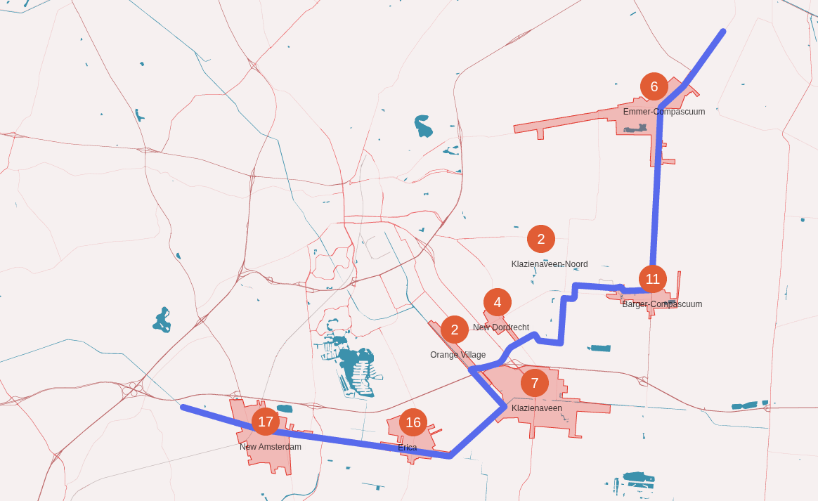
The Veenvaart, which is the name of the route from Nieuw-Amsterdam to Barger-Compascuum, is a very scenic route that takes
you through the beautiful countryside of the region. It consists of several canals that are connected to each other.
The route starts on the Verlengde Hoogeveensche Vaart, globally at Nieuw-Amsterdam, and from there you will continue on the
Vaart towards Erica, after which you will turn left onto the Bargermeerkanaal. The Bargermeerkanaal is a canal that extends the
connection between the Verlengde Hoogeveensche Vaart and the Koning Willem Alexanderkanaal. The Koning Willem Alexanderkanaal is a canal
that was opened on 8 juni 2013 and is named after the current king of the Netherlands. It connects to the Scholtenskanaal.
And this is connected to the St. Josefvaart and that connects to the Veenparkkanaal that finally connects to the Oosterdiep
at Barger-Compascuum.
The Veenvaart is, because of cosisting several canals, a little weird where it starts, and where it ends. Therefore we picked a start/end point
which are easy to find and make sense. To give an idea about the confusion:
Euris Start point: Euris considers the start point at the intersection of the Bargermeerkanaal and the
Koning Willem Alexanderkanaal
Websites start point: There are websites that consider the start point being at Nieuw Amsterdam, or
the connection of the Verlengde Hoogeveensche Vaart and the Bargermeerkanaal.
Our start point: We consider the start point at Nieuw Amsterdam, because it is a nice place to start,
and it is easy to find. It also makes the route a little bit longer, but that is just on paper.
The route section on the Veenvaart Route
On the Veenvaart Route, you will pass the objects:
Nearby Services - Barger-Compascuum
Nearest Bakery: Bakkerij Veenpark Location: Postweg 43, 7884 PJ Barger-Compascuum
Distance: Approx. 450 meters from the canal (6-minute walk)
Best for: Freshly baked rolls, traditional "Veenbeskoeken", and "Smakbrood". Located at the entrance of the Veenpark.
Closest Supermarket (Neighboring Village): Nettorama Emmer-Compascuum Location: Runde Noordzijde 101, 7881 JL Emmer-Compascuum
Distance: Approx. 5.5 km (8-minute drive / 15-minute bike ride)
Best for: Full grocery shopping. Note: The local supermarket in Barger-Compascuum is currently closed.
Alternative Supermarket: PLUS Fischer (Zwartemeer) Location: Klemstrook 2/a, 7894 CN Zwartemeer
Distance: Approx. 4.5 km (7-minute drive)
Best for: Reliable alternative for fresh produce and daily essentials in the next village.
Nearest Gas Station: TinQ Emmer-Compascuum Location: Kanaal A Noordzijde 208, 7881 KT Emmer-Compascuum
Distance: Approx. 5 km (7-minute drive)
Service: 24/7 automated pumps providing Diesel and Euro 95.
Note: Conveniently located along the canal route towards the north.
There is some debate about where the Veenvaart officially ends.
While some sources say it stops at Emmer-Compascuum, others consider the route to continue all the way to Ter Apel.
Technically, the section between Barger-Compascuum and Emmer-Compascuum follows the Oosterdiep.
From there, the waterway connects to the Stads-Compascuumkanaal, which leads towards Barnflair and
eventually Ter Apel. Even if these final sections aren't always "officially" labeled as the Veenvaart, they are part
of the same continuous waterway and are usually included in route descriptions.
So, to get from Barger-Compascuum to Ter Apel, you follow the Veenvaart route through the Oosterdiep and then connect
to the Stads-Compascuumkanaal, which connects to the Ter Apelkanaal. And if you look at the map, you'll see how these
waterways seamlessly connect to form the complete route, as a single canal.
To give you a clear overview, we have listed the waterways section by section below:
Menu: The canals between Barger-Compascuum and Ter Apel
From Barger-Compascuum 🇳🇱 to Emmer-Compascuum 🇳🇱
The route section on the Veenvaart Route
On the Veenvaart Route, you will pass the objects:
Nearby Services - Emmer-Compascuum
Closest Supermarket: Nettorama Location: Runde Noordzijde 101, 7881 JL Emmer-Compascuum
Distance: Approx. 200 meters from the central docks (3-minute walk)
Best for: Complete grocery shopping, fresh meat from their own butchery, and competitive prices.
Nearest Bakery: Bakker Wilco Location: Runde Noordzijde 97, 7881 JK Emmer-Compascuum
Distance: Directly next to the Nettorama (3-minute walk)
Best for: Fresh artisanal bread, Drenthe pastries, and local specialties.
Alternative Supermarket: ALDI Location: Hoofdkanaal Westzijde 13, 7881 AA Emmer-Compascuum
Distance: Approx. 600 meters (7-minute walk)
Best for: Budget-friendly groceries, located slightly further along the canal towards the north.
Nearest Gas Station: TinQ Location: Kanaal A Noordzijde 208, 7881 KT Emmer-Compascuum
Distance: Approx. 1 km from the center (2-minute drive / 12-minute walk)
Service: 24/7 automated pumps providing Diesel and Euro 95.
Note: Located directly along the canal route, making it accessible for filling jerrycans.
From Emmer-Compascuum 🇳🇱 to Barnflair 🇳🇱
Maybe you stopped at Emmer-Compascuum, maybe you continue to Barnflair. Either way, by passing
the Koepelbrug you've entered the Stads-Compascuumkanaal, which is the waterway that connects
Emmer-Compascuum to Barnflair and Ter Apel.
The route section on the Stads-Compascuumkanaal
On the Stads-Compascuumkanaal, you will pass the objects:
From Barnflair 🇳🇱 to Ter Apel 🇳🇱
The route section on the Ter Apelkanaal
On the Ter Apelkanaal, you will pass the objects:
Stay at Ter Apel
Ter Apel is a charming town with a rich history and a welcoming atmosphere. The town is known for its beautiful canals,
historic buildings, and vibrant community. There are several marinas where you can dock your boat, and the town center is
just a short walk away, offering a variety of shops, restaurants, and cultural attractions to explore during your stay.
The monastery is a beautiful example of Gothic architecture and offers a peaceful retreat for visitors.
Overall, Ter Apel is a wonderful destination for boaters looking to experience the charm of Dutch canal towns while enjoying
the amenities and culture of a vibrant community.
Ter Apel is also a nice stop before taking the Haren–Rütenbrock Kanal. Due to the strict german regulations, it's recommended to
plan your journey along the Haren–Rütenbrock Kanal accordingly!
Nearby Services - Jachthaven by Knaap (Ter Apel)
On-site Dining: Paviljoen Koekies & Boefies Location: Oosterkade 5, 9561 NA Ter Apel
Distance: Directly at the marina
Best for: Lunch, dinner, or a drink on the waterfront terrace. Run as a social project for young adults.
Closest Supermarket: Albert Heijn Location: Nederveen Cappelstraat 1, 9561 AL Ter Apel
Distance: Approx. 1 km (12-minute walk / 4-minute bike ride)
Best for: Extensive grocery shopping in the center of Ter Apel.
Nearest Bakery: Echte Bakker Manning Location: Hoofdstraat 34, 9561 JD Ter Apel
Distance: Approx. 1.2 km (15-minute walk)
Best for: Fresh artisanal bread and local Groningse specialties like 'poffert'.
Nearest Gas Station: Tamoil Express Location: Viaductstraat 94, 9561 AC Ter Apel
Distance: Approx. 1.5 km (4-minute drive)
Service: 24/7 automated pumps providing Diesel and Euro 95.
Note: Accessible for refilling jerrycans along the main road.
From Ter Apel to the Haren–Rütenbrock Kanal 🇳🇱
24 Januari 2026
From Ter Apel 🇳🇱 to the entry of the HRK at Barnflair 🇳🇱
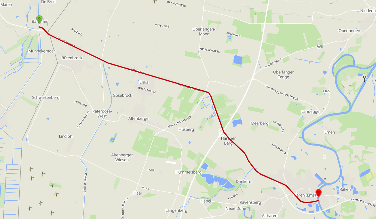
From Ter Apel, you return along the Ter Apelkanaal towards the entry of the Haren–Rütenbrock Kanal at Barnflair.
This section is the reverse of the trip made towards Ter Apel earlier.
Important Notes:
The HRK has strict regulations, so it's important to plan your journey accordingly.
Make sure to check the current status of the canal before departure.
Make sure you have the proper documentation and permits for navigation accross the border.
The route section back on the Ter Apelkanaal
On the Ter Apelkanaal, you will pass the objects:
Entering the Haren–Rütenbrock Kanal
As you approach Barnflair, you'll reach the entry point of the Haren–Rütenbrock Kanal.
This is where you will transition from Dutch waterways to the German canal system.
Make sure to have all your documentation ready for crossing the border and be aware of the regulations that apply in Germany.
By continuing down here, you will be taken to the page about the Haren–Rütenbrock Kanal, where you can
view more information about the entry point and the procedures.
One of the calmer routes is the Haren–Rütenbrock canal
which takes you from the Netherlands to the
Dortmund-Ems-Kanal
Major German federal waterway running from Dortmund to the port of Emden. The HRK
connects to it at Haren (Ems), approximately at km 212.
in Germany.
Fun fact is that when you want to navigate the canal, you have to do this in
convoy
All vessels transit together as a group, one behind the other. The tallest boat leads
so that bridge operators know the maximum clearance needed.
.
This starts (coming from the Netherlands) at the first bridge. The highest boat needs
to be all the way up front so they can measure how high the bridges have to be opened.
The bridges are remotely controlled. In the canal, there are no places to "moor",
so you have to continue to the end of the canal.
This was already documented about the Haren–Rütenbrock canal in 2008:
The waterway from Ter Apel to Haren (Ems) on the Dortmund–Ems Canal
With the exception of the River Rhine, this is the only cross-border inland waterway connection with Germany.
The lock in the Haren–Rütenbrock Canal at the Dutch border is operated by the lock keeper
of the 7th Verlaat. The lock directly across the Dutch border is normally left open.
When arriving from Germany, vessels must, at the Dutch border near the ESSO petrol station
(Potze family) on the Rütenbrockerweg opposite the lock, contact the lock keeper of the 7th Verlaat
by telephone for the operation of the bridges and locks in the Dutch section of the
Haren–Rütenbrock Canal.
The telephone number is available at the petrol station (06-56 92 35 457).
See further instructions at the bridge.
Operation of structures in the Haren–Rütenbrock Canal (Germany)
The operating hours of the structures in the Haren–Rütenbrock Canal as known at the
time were:
From 1 April to 1 November
Monday to Friday: 08.00 – 12.30 and 13.00 – 18.00
Saturday: 08.00 – 13.00
Sundays and public holidays: closed
In exceptional cases, different operating hours could apply.
Due to the lack of mooring facilities, vessels were required to enter the canal
at least 2.5 hours before the end of the operating hours.
During the period from 1 November to 1 April, passage was only
possible after prior telephone notification, at least one week in advance.
Operation was carried out remotely from Haren (Ems). If required, contact could be
made with:
A. NLKW Operations Office Meppen
Haselühner Strasse 78
49716 Meppen
Tel. +49 5931 406 175
B. Schleuzel Operations Building
Tel. +49 5932 4376
Mobile: +49 171 477 2783
Haren as a stopover
While not too big, Haren is a very nice town to stay for a night (or more). Within walking
distance, there are nice restaurants, grocery shops and you are right in the middle of the
center. You'll also find a nice museum "Schifffahrtsmuseum". Certainly worth a visit.
Skipper's Information (HRK)
Here is some practical "skipper's information" for the Haren–Rütenbrock Canal (HRK),
with emphasis on convoy sailing (
Kolonnenschleusungen
German term for convoy lockage — the regulated system where all vessels transit the
canal together in a single group, coordinated through fixed entry windows at each lock.
), transit rules, and what you need to plan for in practice.
Convoy navigation (Kolonnenschleusungen) and meeting restrictions
During construction or maintenance works, the HRK may be operated with convoy lockages
from both directions, without opposing traffic in the work section.
In practice this means:
You navigate through the canal in a group/convoy (one after another);
There are fixed "entry windows" at the locks;
You cannot simply stop or moor along the way if you miss your slot: if you are late,
you will normally be held back until the next convoy or operating period.
Example of such a regime (season 2025 due to bridge and construction works):
Entry at
Schleuse 1
The lock at Haren at the connection with the Dortmund-Emskanal.
This is where you pay the fees and where the convoy lockages are coordinated from.
(Haren): 08:00–10:00
Entry at
Grenzschleuse
The border lock at Rütenbrock on the German side of the Dutch–German border.
Under normal conditions it is left open, but under construction regimes it becomes
the entry point for southbound convoys.
(Rütenbrock): 13:00–15:00
Note: these time windows were explicitly published for the limited 2025 navigation season.
For 2026, times and procedures may change; always check the latest official notices before
departure.
Season, closures, and lack of flexibility
In 2025, the canal was only partially open due to construction works and then closed
from 30 September, with reopening announced for the 2026 season. Temporary closures,
changed operating hours, or additional waiting times may occur due to ongoing works.
Some sources emphasise that you cannot enter late in the day, because the entire route
must be completed in one run. In practical terms: you must enter well before the end of
the operating window.
Dimensions, draught, and temporary restrictions
During the 2025 works, the maximum permitted beam was temporarily reduced from 6.00 m to 5.50 m.
Always verify whether this restriction still applies in the season you intend to transit.
Locks and bridges: what to expect en route
Expect several locks and bridges along the canal. There are references to approximately
four locks and twelve bridges, operated and coordinated from Schleuse 1 in Haren.
In practice this means: have
fenders
Rubber or foam bumpers hung over the side of the boat to protect the hull when
mooring alongside lock walls, pontoons, or other vessels.
and mooring lines ready, and maintain proper spacing
and speed discipline when sailing in convoy.
Fees / charges (HRK)
As of 1 April 2026,
NLWKN
Niedersächsischer Landesbetrieb für Wasserwirtschaft, Küsten- und Naturschutz —
the Lower Saxony State Office for Water Management, Coastal Defense and Nature
Conservation. They administer the HRK on the German side.
replaced the old per-category flat fees with a day-ticket and vignette system:
Recreational craft: €10 / day
Commercial / charter craft: €20 / day
Annual vignette (full season): €25
Human-powered craft not using locks or movable bridges: free
A multi-region annual vignette covering all three NLWKN waterways (HRK, Elbe-Weser,
and East Frisia) is also available via the DMYV. NLWKN cited rising electricity, fuel,
and staffing costs as the reason for the change.
Payments are (normally) made at Lock 1 at Haren, but can also be performed
at the lock at the border.
Leitstelle / Schleuse I (Haren-Rütenbrock-Kanal)
Tel: +49 171 4772738
More information regarding the fees you can get from the NLWKN
The same source provides links to the official tariff regulations and the canal usage
regulations, which are useful to download or print and keep on board.
Practical navigation tips (very relevant on the day itself)
Plan to transit the canal in one continuous passage. Do not rely on convenient waiting or
resting places to recover from a missed entry window.
Arrive early at the entry lock, especially when convoy sailing is in force. Make sure you
are ready well before the opening window, with lines, fenders, and communications prepared.
Allow for waiting time caused by construction works and lock operation, and expect a
strict no-meeting rule in work sections, meaning little operational flexibility.
Shortly before departure, always check the latest
Notices to Skippers
Official navigational warnings published by waterway authorities (Dutch: Berichten aan
Schippers; German: Nachrichten für Schiffer). Check these for lock closures, temporary
restrictions, and current operating times.
for the HRK and, if applicable, the
ELWIS
Elektronisches Wasserstraßen-Informations-System — the German federal Electronic
Waterways Information System, providing up-to-date notices, charts, and traffic data
for German federal waterways.
/
WSV
Wasserstraßen- und Schifffahrtsverwaltung des Bundes — the German Federal Waterways
and Shipping Administration, responsible for maintaining and operating federal waterways
including the Dortmund-Ems-Kanal and the HRK.
publications for current operating times and any temporary restrictions.
How to get to the Rütenbrock entrance of the Canal
To get to the Dutch side of the canal, there are roughly 2 main routes:
From the North (
Ter Apelerkanaal
The canal connecting Ter Apel to the northern Dutch waterway network via Stadskanaal
and Groningen. Historically the primary approach route to the HRK.
)
From the South (
Stads-Compascuumkanaal
The final Dutch canal before the German border, connecting the peat-district canal
network to the Barnflair lock and the start of the HRK.
)
Both routes go over inland canals in The Netherlands. And both bring you to the
Barnflair
The Dutch harbor and bridge/lock at the start of the Haren–Rütenbrock Canal,
marking the Netherlands–Germany border crossing point for inland waterways.
Bridge & Lock. The bridge is a lifting bridge and the lock is normally open.
From the North
This is the historically oldest route to the HRK. The southern route was only
re-opened in 2013.
When you use the route from the North, you will face objects on the route. For example:
When you navigate from Winschoten, along Stadskanaal to Barnflair, it is approx. 45 km.
But there will be at least 6 locks and 51 bridges on this entire stretch.
Another route takes you from Center city Groningen to Barnflair: Approx 65 km, 34 bridges and 2 locks.
So, seen from Andijk you can take the northern route(s):
Andijk - Stavoren -
Prinses Margrietkanaal
Major Dutch canal through Friesland, connecting the IJsselmeer ports (Lemmer, Stavoren)
to the Groningen canal network. Named after Princess Margriet of the Netherlands.
- Groningen - Stadskanaal - Barnflair
(***) This was from the Prinses Margrietkanaal, mainly the route
taken by Jacco in 2008.
From the South
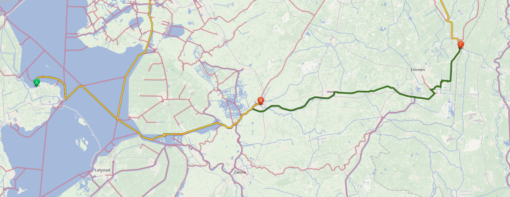
Fig.7 - Erica - Barnflair
In 2008, when Jacco made this trip, this route was NOT available.
The route south to Meppel became available in May 2013. It is also known as the Erica - Ter Apel route.
This route connects the southern parts and northern parts again. The connections were not
navigable since end 1969 (according to local information). The restored route was originally meant
to transport fuel.
We can make a long story short: The old routes used for inland transportation, that had not been
in use since the late 1960s, are (or have been) made available for pleasure vessels to navigate.
Places like Emmen are now reachable by boat again. (Not that there are ANY facilities in Emmen!)
For example: When you navigate from Almelo, it is possible to navigate (roughly) towards Coevorden
and there head to Barnflair. (Be aware of your dimensions!)
Online Info
We found some online information about the HRK and the surrounding areas:
We try to update this website as often as possible!
The upgrade plans
24 Januari 2026
Our upgrade plans.
Support the KNRM!
Help them to help others!
KNRM
I would like to ask you to become a donor for the KNRM.
The KNRM is a fully private organisation, completely run by volunteers, financed by contributions and donations.
You will find all information about them on the website.
You can choose from a single one time payment or a monthly or yearly donation. Please Support them.
Our personal opinion is that every person out on the water should, by law be told to make a donation of €25,- per year.
But that is just our opinion.
Copyright, Disclaimer & Attribution
The legal stuff needed because of stupid....
The content on this website may include materials such as text, images, videos, and other media that are the property of their respective owners. All trademarks, logos, and copyrighted works remain the intellectual property of their original creators.
We strive to properly attribute and acknowledge all sources. If you are the copyright owner of any material featured on this site and believe it has been used without appropriate credit or permission, please contact us at [your contact email] so we can promptly address the issue.
Where applicable, the use of third-party content falls under fair use, creative commons licenses, or other applicable legal provisions. If specific attribution is required, it is provided directly alongside the respective material.
The images and data on this site are NOT intended for navigation or critical decision-making.
Any reliance on this information is strictly at your own risk. The information on this site is for PERSONAL USE ONLY.
You may print or copy parts of it for your own private use. Commercial use is strictly FORBIDDEN.
Do not sell, rent, or use this data for profit. Unauthorized commercial exploitation will be met with rigorous legal action to the fullest extent of the law
Furthermore, automated data scraping, harvesting, or feeding this content into large language models or AI systems is strictly PROHIBITED.
If automated tools crawl this site without express written permission, access will be blocked, and those responsible will be held liable for
unauthorized bandwidth usage and intellectual property infringement.