Connecting the Ruhrgebiet to the North Sea 🇩🇪
The Dortmund-Ems Kanal is one of the longer canals in Germany. It runs from Dortmund to Papenburg, where it connects to the Unterems. From there you can navigate further North to the Dollard and enter the Netherlands at Delfzijl, or you can navigate through the Dollard to Emden.
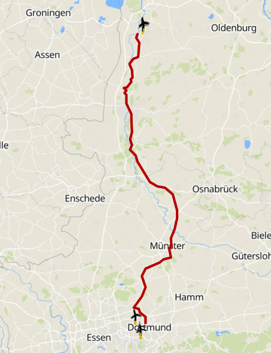
This canal connects the industrial area of the Ruhrgebiet to the North Sea. It is a very important canal for commerce, and you will see commercial traffic on this canal. But it is also a very nice canal for recreational boating. The approx. 226 km long kanal is the german way of not being dependent on The Netherlands for reaching the North Sea and then further on to the rest of the world.
But before you reach Papenburg, you cross the locks at Herbrum, taking you from Fresh to Salt water.
From the start at Dortmund, the first part of the canal is, at the time of writing, less interesting for boaters although the city of Dortmund is making changes at the Stadthafen. The disadvantage is that you have to navigate first 15 - 16 km to get to Dortmund Stadthafen. And that part is not very interesting. You mostly navigate through the industrial part of Dortmund. There are NO marina's in this part of the DEK. Specifically, there are no Marina's from KM 0.0 to KM 16, where the connection with the Rhein-Herne-Kanal is.
At the "triangle" style intersection, are some marinas. And further on the DEK, there are more marinas to be found. Further north you will pass through places like Münster, Datteln, Rheine, Haren and finally Papenburg. Each place has its own charm and marinas to offer. Haren is special because it is the intersection with the HRK to Ter Apel on the Dutch side.
The first (and at the time of writing not so interesting) 16 kilometers of the DEK
The first 16 kilomters of the Dortmund-Ems-Kanal, staring in Dortmund, are not very interesting. Technically you could see this section as a "dead arm" of the DEK. This implies that you have to enter this section, go to the end, and return the same way you came. At Dortmund it is mostly industrial area and there are no marinas. You can see a lot of cargo ships and freighters passing by. Actually, that might be the only interesting thing on this part of the canal for now and the near future.
If you want to visit this spot, there is no other option than take the lock and return the same way after your visit. The Wasserwanderrastplatz is at Dortmund and approx. 16 km behind the lock.
The Waltrop-Hebewerk
In 1988, the Waltrop-Hebewerk was put into operation. It is a hydraulic lift lock that lowers boats 13.5 meters (44 feet) from the Dortmund Basin to the Dortmund-Ems Kanal, or raises them in the opposite direction.
The Intersection with Rhein-Herne-Kanal
Immediately below the Waltrop Hebewerk and lock complex lies the junction with the Rhein-Herne-Kanal. This waterway intersection is a key crossroads for boaters navigating between Dortmund, the Ruhr area, the connection to the Rhein (Rhine) and further to the north of Germany to end in the North Sea.
Your navigation choices at this junction depend on your direction of travel:
- Coming from the North: Traveling south on the DEK brings you to the junction where you can turn right into the Rhein Herne Kanal, or proceed straight to ascend into Dortmund.
- Heading North on the DEK: If you just descended the Hebewerk from Dortmund, continue straight ahead along the Dortmund Ems Kanal towards Münster and the North Sea.
- Turning West into the Rhein Herne Kanal: Branch off to port after descending the lift to cruise through the Ruhr valley towards Duisburg.
- Exiting the Rhein Herne Kanal: Cruising east to the end of the canal brings you onto the DEK, where turning right leads south to the Hebewerk and turning left heads north towards Münster.
Taking the Rhein Herne Kanal brings you to Duisburg where you join the Rhine. From Duisburg, cruising downstream on the Rhine (Rhein) takes you into the Netherlands, while navigating upstream on the Rhine (Rhein) leads south past Düsseldorf and Cologne towards the Mosel river at Koblenz or even beyond.
Between Schleusengebiet Henrichenburg and Münster on the DEK
From the Intersection at Waltrop and the Schleusengebiet Henrichenburg, heading towards the harbor of Münster it is about a 52 km trip.
During this trip, you will pass the following intersections:
- Wesel-Datteln-Kanal at Datteln (KM 21.3)
- Datteln- Hamm-Kanal at Datteln (KM 21.5)
At the intersection of the Wesel-Datteln-Kanal you can find the Bunkerstation.
Also, remember that you are in one of the major industrial areas in Germany: The Ruhrgebiet.
This area is very busy with mostly commercial traffic. So keep your eyes open and also look behind you.
Objects between Waltrop and Münster
Between Waltrop and Münster, you will pass the following objects:
From Münster to the 'Nasses Dreieck' on the DEK
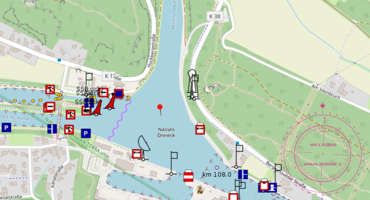
From the harbor(s) of Münster heading towards the intersection at Nasses Dreieck it is about a 40 km trip.
At the Nasses Dreieck, is the intersection with the Mittelland Kanal that goes towards north to Osnabrück and furtheron eastward towards Hannover and Magdeburg. Allong the way of the Mittelland Kanal, there are several intersections, connecting to, amongst others, the river Weser, the Elbe-Seitenkanal, etc.
Make sure that you have an ear on the VHF on the correct channels and make use of your AIS (if you have those).
Objects between Münster and the Nasses Dreieck
Between Münster and the Nasses Dreieck, you will pass the following objects:
From the 'Nasses Dreieck' to Hanekenfähr on the DEK
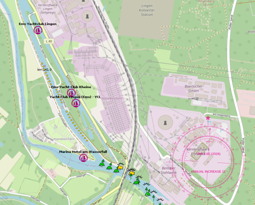
Heading north from the Nasses Dreieck towards Hanekenfähr it is about a 34 km trip.
Allong the way of the Dortmund-Ems-Kanal, there are several objects to pass. When you have stayed at the Wasserwanderrastplatz Bergeshövede, we advise you to refuel at bunkerstation Bergeshövede at KM 108. Further north of here the next possibility to refuel is at Haren.
Make sure that you have an ear on the VHF on the correct channel(s) and make
use of your AIS (if you have those).
Objects between Wasserwanderrastplatz Bergeshövede and Hanekenfähr
Between Wasserwanderrastplatz Bergeshövede and Hanekenfähr, you will pass the following objects:
From Hanekenfähr to Haren on the DEK
Hanekenfähr to Haren is about 34 km.
Hanekenfähr isn’t actually a village, even though it sounds like one! In everyday life, locals use the name to refer to the massive power plant nearby. Originally, Hanekenfähr was just a historic spot and a waterway intersection right south of Lingen in Germany's Emsland region. While it’s not the official name of the power stations, everyone from locals to the local industry uses it as a handy shorthand for the entire area, including the nearby substation.
After your stay at Hanekenfähr, the DEK continues towards Lingen, Meppen and Haren.
Make sure that you have an ear on the VHF on the correct channel(s) and make
use of your AIS (if you have those).
Objects between Hanekenfähr and Haren
Between Hanekenfähr and Haren, you will pass the following objects:
The town of Haren
Haren is a small town in Germany, located on the Ems river. It is a popular destination for boaters and tourists, with a charming old town and a variety of shops and restaurants. The town is also home to the Haren Marina, which offers mooring facilities for boats of all sizes.
From Haren, you can access the Dortmund–Ems Canal (DEK), which is a major waterway in Germany that connects the cities of Dortmund and Emden. The canal is approximately 269 kilometers long and is used for both commercial and recreational boating. It passes through several towns and cities along the way, including Münster, Datteln, and Rheine, and offers a scenic route for boaters to explore the German countryside.
One of the highlights of boating on the DEK is the opportunity to see the historic locks and bridges that line the canal. The locks are used to raise and lower boats as they navigate the canal, and many of them are still in operation today. The bridges that cross the canal are also a sight to see, with some of them dating back to the 19th century.
Overall, Haren and the Dortmund–Ems Canal offer a unique and enjoyable boating experience for those looking to explore the waterways of Germany. Whether you're a seasoned boater or a first-time visitor, there is something for everyone to enjoy along this scenic route.
Technically, at the German side of the HRK, you have a similair situation as in The Netherlands:
- Going North: on the Dortmund–Ems Kanal towards Emden
- Going South: on the Dortmund–Ems Kanal towards Dortmund
Alias for the Dortmund–Ems Kanal is DEK
Both routes have their charmes and options. The route North takes you to the connection of the Küstenkanal near Dörpen, or to Herbrum, where you go from fresh to salt water at the lock. Further North you can enter the Leda, or take other connections inland towards the east and finally end up on the Dollard, where you can get to Emden or Delfzijl.
The route South takes you to Dortmund, and from there even further into Germany. Along the DEK there are other canals connecting, taking you further east. And using this route you can also reach the Rhine river to head back to The Netherlands.
Heading North
Heading south
When heading south, you are heading towards connections that taken you further into the eastern parts of Germany, like the "Mittellandkanal" all the way to the Elbe river. Or going to Munster, connecting to the Datteln-Hamm-kanal that brings you to (obvious) Hamm, and connecting at Datteln to the Rhein-Herne-kanal. The Rhein-Herne-kanal will take you to the Rhine river at Duisburg (obviously).
The Herbrum Lock
The Herbrum Lock is a lock on the Dortmund-Ems Canal in Germany. It is located in the municipality of Papenburg, in the state of Lower Saxony. The lock was built in 1904 and was opened in 1905. It is 90 meters long and 10 meters wide. The lock is used to raise and lower boats as they navigate the canal. It is operated by the Federal Waterways and Shipping Administration of Germany.
Fun Fact: The moment you are coming down the DEK from the South coming from the intersection at Dörpen, you will enter lock Herbrum. See also the route of the Canicula where they take the HRK to Haren and then the DEK to Herbrum. And from Herbrum to Ditzum.

This image is copyright of "T H".
Lock Herbrum 2008
In 2008, only the east basin of Lock Herbrum was available. Now the west basin is in use.
The old lock and pleasure craft
As you can see on the picture, the old chamber of the lock was not very "pleasure craft"
friendly. Actually, it was even more pleasure craft unfriendly than the other
locks on the DEK. In 2008, only the eastern lock chamber at Herbrum Lock was in operation.
Today, the western lock chamber is in use, while the old one has been closed and completely
filled with earth. The former lock chamber was extremely unfriendly to recreational boating.
As can be seen in the photograph, the lock was clearly designed for commercial shipping.
The other locks, with their coarse sheet pile walls and almost no bollards, were and still are not particularly pleasant for pleasure craft either, but this lock was a real challenge. This was especially true because the lock transitions from fresh water to salt water. This has surprised many boat owners making this passage for the first time.
Salt water is heavier than fresh water and therefore enters the lock beneath the fresh water. As a result, the fresh water pushes vessels toward the salt water side, creating a current inside the lock that runs from aft to forward. Most people expect the current to come from ahead. Not in this lock.
As can also be seen in the photograph, there was very little opportunity for pleasure craft to secure themselves properly due to the lack of bollards. In 2008, Erwi was therefore secured on the right side of the photograph, to the wooden structure in the right foreground. With considerable effort and improvisation, it was possible to keep Erwi in position. It was far from ideal.
Support the KNRM!
Help them to help others!
I would like to ask you to become a donor for the KNRM.
The KNRM is a fully private organisation, completely run by volunteers, financed by contributions and donations. You will find all information about them on the website.
You can choose from a single one time payment or a monthly or yearly donation. Please Support them.
Our personal opinion is that every person out on the water should, by law be told to make a donation of €25,- per year. But that is just our opinion.
Copyright, Disclaimer & Attribution
The legal stuff needed because of stupid....
The content on this website may include materials such as text, images, videos, and other media that are the property of their respective owners. All trademarks, logos, and copyrighted works remain the intellectual property of their original creators.
We strive to properly attribute and acknowledge all sources. If you are the copyright owner of any material featured on this site and believe it has been used without appropriate credit or permission, please contact us at [your contact email] so we can promptly address the issue.
Where applicable, the use of third-party content falls under fair use, creative commons licenses, or other applicable legal provisions. If specific attribution is required, it is provided directly alongside the respective material.
The images and data on this site are NOT intended for navigation or critical decision-making. Any reliance on this information is strictly at your own risk. The information on this site is for PERSONAL USE ONLY. You may print or copy parts of it for your own private use. Commercial use is strictly FORBIDDEN. Do not sell, rent, or use this data for profit. Unauthorized commercial exploitation will be met with rigorous legal action to the fullest extent of the law Furthermore, automated data scraping, harvesting, or feeding this content into large language models or AI systems is strictly PROHIBITED. If automated tools crawl this site without express written permission, access will be blocked, and those responsible will be held liable for unauthorized bandwidth usage and intellectual property infringement.
Powered by Haringstad
Build with VIM
© Haringstad, J and S van Koll