Rhein Route Sections -
Crossing the border on the Rhein 🇩🇪
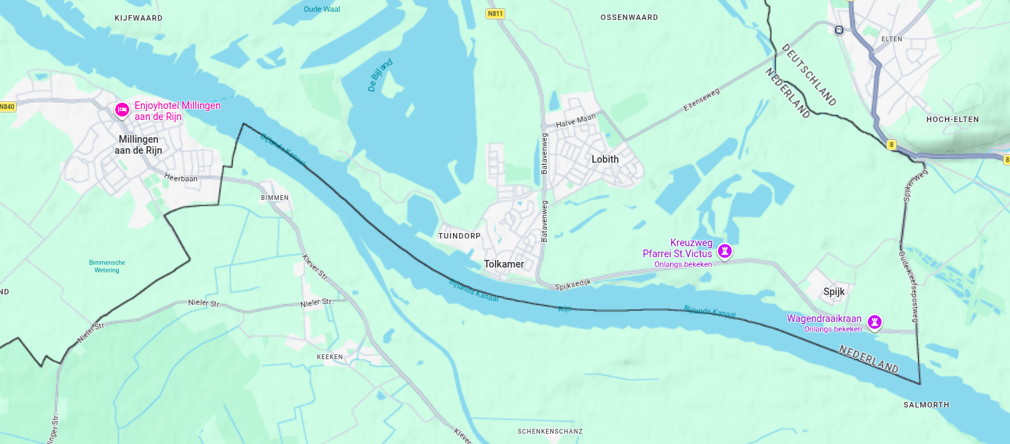
For people with a large wallet, you can surely take the route in de opvaart" on the Rhine (Rhein) river. The "Rhein" enters between Spijk and Millingen aan de Rijn, the Netherlands. Between those two locations, the rhine is the border between The Netherlands and Germany. This is truly the backbone of Europe where it comes to waterways and transportation. As long as those waterways are navigable, cargo and tankers will be heading up and down.
You can go up the Rhine and take (amongst others) the following connections (besides marina's and harbors):
- KM 864: Entry to Griethouser Altrhein
- KM 813: Entry to Wesel-Datteln Kanal
- KM 780.5: Entry to Hafen Kanal - Rhein-Herne Kanal
Down here, you will find routes that are worked out on the Rhein already.
Rhein Routes
From Strasbourg to Karlsruhe -
Abfahrt
From Strasbourg 🇫🇷 to Karlsruhe 🇩🇪
Assumption: We do assume that you've stayed in the marina Kehl and heading downstream.
2 Marina's near Karlsruhe
There are 2 marina's : Motor-Yacht-Club Wörth e.V. and Motorbootclub Karlsruhe e.V. Both are located near Karlsruhe. Both are also accross from each other, so you can easily choose one of them. The Motor-Yacht-Club Wörth e.V. is located at the Wörth harbor, which is a bit less (50 meters) north than the Motorbootclub Karlsruhe e.V.
- Motor-Yacht-Club Wörth e.V.: Located at the Wörth harbor on the left bank. Near the Maximilian Center, which is a shopping center. (approx 1.5 km walking distance). The marina has approx. 30 berths and is open all year round. The marina is small, but has a ramp and no stairs. The marina also has a boat lift and a boat ramp. The marina is located at Rhein PK 362.6 Left Bank.
- Motorbootclub Karlsruhe e.V.: Located at the Karlsruhe harbor. Near the Karlsruhe train station. The marina has approx. 20 berths and is open all year round. The marina has a restaurant and a bar. The marina also has a boat lift and a boat ramp. The marina is located at Rhein PK 362.7.
We advise you to first see if Motor-Yacht-Club Wörth e.V. has availability before booking the Motorbootclub Karlsruhe e.V., because the Motor-Yacht-Club Wörth e.V. is closer to the shopping center. Both locations are a stopover to get to Mannheim.
The route of today
On the route, you will pass the objects:
From Karlsruhe to Mannheim
Abfahrt
From Karlsruhe 🇩🇪 to Mannheim 🇩🇪
Assumption: We do assume that you've stayed in the marina Motor-Yacht-Club Wörth and heading downstream.
Marina's in Kiefscher Weiher
The most smart way to spend the night before entering the Neckar, is at one of the marina's within the Kiefscher Weiher. This is upstream from the mouth of the Neckar. The Mouth fo the Neckar is globally 10 km downstream from the marina's in Kiefscher Weiher. The marina's are located at Rhein PK 418.9. The marina's are open all year round. The marina's have a restaurant and a bar. The marina's also have a boat lift and a boat ramp. There are several marina's at the Kiefscher Weiher.
Pro Tip: Please note that the marina's are small and may have limited availability, especially during peak seasons. Therefore we do advise to book in advance.
The route of today
On the route, you will pass the objects:
From Mannheim to Mainz
Abfahrt 14 km/h
From Mannheim 🇩🇪 to Mainz 🇩🇪
Abfahrt am Rhein. Yep, heading downstream from Mannheim, to Mainz.
There are two options here: Or you have been up the Neckar, or you started more upstream at the Kiefscher Weiher. Depending on which of those two options you took, you will be either on the right bank of the Rhein, or on the left bank of the Rhein. The route is the same, but the marina's you can stay at are different. The direction of the route is also the same, but the start points of this stretch of the route is different.
For conveniance we will start the objects list at the Kiefscher Weiher. At a certain moment, you will reach the Neckar and you can continue your way to Mainz.
Came down the Neckar River?
We suggest that you start this trip from "Segler-Vereiniging Mannheim e.V. (SVM)", km 429.5, which is on the northern side of Mannheim. This is a nice place to stay after arriving from or Kehl, or Heidelberg. This marina can be reached by using the Hafenschleuse1 Mannheim in the Neckar, or trough the Altrheinhafen.
This marina is small, but decent and is not in a very busy section. It is in one of the old arms of the river. It is not too large, but fine for a good night of rest to navigate to Mainz.
Marina im Zollhafen Mainz
Address: An der Wied 12, 55120 Mainz, Germany (Left Bank)
A modern, sheltered urban marina located in a former customs basin, surrounded by contemporary architecture and local amenities. Also, this marina has a ramp, instead of a set of stairs, or a combination of a ramp and stairs, which makes it easier for people with a wheelchair/booster.
Be aware, this is not the most cheap solution! The fact that you are approx 50 meters from the nearest large supermarket is a huge plus.
Bridge Clearance & Access the Zollhafen
- Type: Folding bridge (Klapbrug) at the entrance.
- Vertical Clearance (Closed): Approx. 5.00m at mean water level.
- High Water Warning: Clearance decreases to approx. 4.00m when the Mainz gauge reaches 4.00m.
- Opening: Can be opened for taller vessels by prior arrangement with the harbor master.
Reservations & Practical Info
Advance booking is required (at least 24 hours before arrival).
- Phone: +49 (0) 176 10141675
- Website: Official Contact Form
- Max Vessel Length: 16.0 meters.
Note: Supermarkets (REWE/Alnatura) and various restaurants are within 5 minutes walking distance along the harbor promenade.
The route of today
On the route, you will pass the objects:
At Koblenz 🇩🇪
Day 1: The Rhein at Koblenz 🇩🇪
Where the Mosel 🇩🇪 connects to the Rhine 🇩🇪
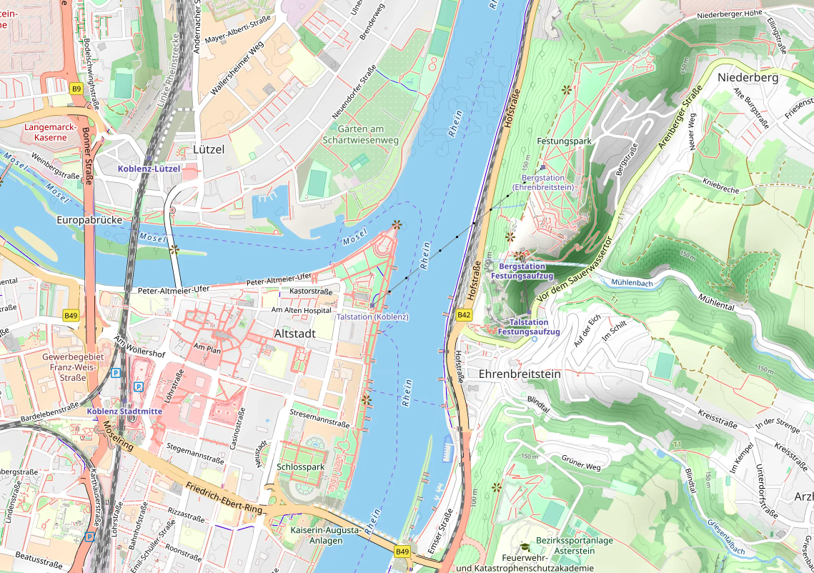
From the spires of Koblenz to the North Sea gates of Rotterdam.
The Grand Artery
As the sun rises over the Deutsches Eck in Koblenz, the water begins to churn. This isn't just a scenic vista; it is the view over Europe's most vital logistics corridor. Between the Dutch city of Rotterdam and Koblenz, and even beyond, the Rhine is the liquid highway, acting as the primary artery pumping lifeblood (cargo) from the Port of Rotterdam deep into the heart of the continent.
Every vessel trailing a wake represents a mountain of goods: raw minerals for the Ruhr, chemicals for Basel, and thousands of containers destined for kitchen tables across Germany. Without this stretch of water, the gears of European industry would grind to a halt.
German Engineering vs. Mother Nature
The Germans view the Rhine not as a static landmark, but as a high-precision machine that requires constant tuning. Maintaining this "main artery" is a Herculean task of engineering and vigilance:
- Dredging & Depth: To combat the increasing frequency of low-water summers, German authorities are engaged in the Abladeoptimierung (Navigation Optimization) project. This ensures that even during droughts, deep-draft barges can still pass without grounding.
- Lock & Dam Modernization: Millions of Euros are funneled annually into digitizing and reinforcing the infrastructure to ensure 24/7 uptime for cargo traffic.
- Ecological Balance: Maintenance isn't just about concrete; it's about stability. German environmental agencies work tirelessly to reinforce banks and manage sediment, ensuring the river remains a sustainable resource for future generations.
⚠️ Warning⚠️ Upstream to the marina
⚠️ Be aware of the current on the Rhein! Make sure you check the current waterspeed. The table down here gives you some indication of how fast the water will flow. On Euris you will find the actual water level measurements. On PegelOnline you will find the other source of the actual waterlevel at Koblenz.
| Water Level (Gauge Koblenz) |
Current Speed (km/h) | Status & Navigation Notes |
|---|---|---|
| Low Water (< 150 cm) | 2.9 – 4.0 km/h | Low flow; restricted draft for cargo vessels. |
| Average Water (approx. 300 cm) | 4.3 – 5.4 km/h | Standard conditions; average flow of ~1.6 m/s. |
| High Water (> 500 cm) | 6.5 – 9.0 km/h | Strong currents; shipping suspended above 650 cm. |
⚠️ Do not UNDERESTIMATE the current!
Caution ⚠️
Please make sure your vessel is capable of fighting the current
while you are going in the Opvaart
Opposing the Parel, We advise a little quieter marina, closer to the city. Actually on the left bank of the Rhine. This marina is Hafen Yachtclub Rheinlache. Yes, this implies that the boat has to work, but it will be worth it.
We are going to stay at Yachtclub Rheinlache Koblenz e.V
Because the pontoons of Marina Rhein-Marina Kaiser Wilhelm are virtually facing the Rhein, wash will be entering rocking them. Larger vessels are less affected by the swell entering the harbor, as the pontoons are located relatively close to the main fairway. However, because the Rhine is a busy shipping route used 24/7 by heavy cargo ships and tankers, their constant wash creates significant movement in the water. While larger ships remain stable, smaller vessels can end up 'dancing' quite vigorously in these waves, making it essential to secure your lines properly.
The route of today
On this section of the route you will pass the objects:
Nearby Services - Yachtclub Rheinlache (Koblenz)
-
Closest Supermarket: REWE Markt
Location: Mainzer Straße 120, 56068 Koblenz
Distance: Approx. 650m (8-minute walk from the marina)
Best for: Full grocery range, fresh produce, and a bakery; very convenient for a quick restock. -
Main Shopping Hub: Lidl & dm-drogerie
Location: Mainzer Straße 124-126, Koblenz
Distance: Approx. 750m (9-minute walk)
Best for: Budget-friendly groceries and drugstore essentials, located right next to the REWE. -
Note on Fuel: Convenient Roadside Station Nearby
Status: There is no fuel pump directly at the water for boats at this club.
Nearest option: Aral Station (Mainzer Str. 114).
Distance: Approx. 600m (7-minute walk from the harbor).
Recommendation: This is one of the most accessible road stations for boaters in Koblenz; easy to reach with a trolley or jerrycans via a flat walk.
Downstream to Oberwinter 🇩🇪
Day 1: Downstream on the Rhein
Speeding down the Rhein 🇩🇪
Depending on how fast the flow of the Rhein is, the speed (SOG) will be increased by that. By leaving the marina, we have to cross over to the other side of the river. Due to the higher speed of the currents you MUST make sure that you can cross safely! Use your AIS, you Marine Radio and your extra eyes.
During this leg, you will pass some very important historical sites. Among those that where very important in ending the war.
The Remagen Bridge
View Larger Map
At KM 632.8 you find the ruins of the trainbridge at Remagen. This bridge was the actual "breaktrough" that the allies needed to finish the war.
On March 7, 1945, troops of the U.S. 9th Armored Division reached the Rhine and were stunned to find the bridge still standing. The German defenders had attempted to blow it up, but the charges failed to destroy the main structure. American forces quickly charged across under heavy fire, securing the first permanent Allied bridgehead over the Rhine.
This breakthrough was a massive strategic blow to the Third Reich. General Eisenhower famously remarked that the bridge was "worth its weight in gold," as it allowed the Allies to move tanks, troops, and supplies deep into the German heartland much faster than anticipated. It bypassed the need for many risky amphibious assaults and contributed to the rapid collapse of German defenses in the West.
Although the bridge eventually collapsed into the river ten days later due to structural damage and German shelling, the Allies had already established a firm grip on the eastern bank. This success is credited with saving thousands of lives by accelerating the end of the conflict by several weeks.
Significant Allied Rhine Crossings (1945)
Following the capture of the bridge at Remagen, the Allies launched several massive operations to cross the Rhine and enter the German heartland.
Operation Plunder (March 23–24, 1945)
This was a massive, coordinated assault by the 21st Army Group under Field Marshal Montgomery. It involved over one million soldiers and was the primary northern thrust into Germany.
- Wesel: Captured by British Commandos after a heavy aerial bombardment, serving as a vital logistics hub for the push into the Ruhr area.
- Rees: Crossed by the 51st Highland Division, where they faced some of the most determined German resistance during the operation.
- Xanten: A key jumping-off point for Allied forces to establish bridgeheads and link up with airborne troops.
Operation Varsity (March 24, 1945)
The largest single-day airborne operation in history. Over 16,000 paratroopers and thousands of gliders landed near Hamminkeln to seize high ground and silence German artillery overlooking the river crossings.
The Northern Sector (Dutch Border)
Near the towns of Emmerich and Elten, Canadian and British troops forced crossings in late March. These maneuvers were essential for the subsequent liberation of the northern Netherlands and the isolation of German forces in the west of Holland.
These crossings collectively shattered the German "Rhine Defense" and led to the rapid conclusion of the war in Europe.
The route of today
On this section of the route you will pass the objects:
Nearby Services - Yachthafen Oberwinter
-
Closest Supermarket: Edeka Rudolphi
Location: Hauptstraße 133, 53424 Remagen-Oberwinter
Distance: Approx. 200m (3-minute walk from the marina entrance)
Best for: A full-range supermarket with a bakery, fresh produce, and a butchery. Extremely convenient for boaters. -
Alternative Shopping: REWE
Location: Mainzer Straße (Remagen center)
Distance: Approx. 4 km (requires a bike or short train ride)
Best for: Extended shopping trips if specialized items are needed beyond the local Edeka. -
Note on Fuel: Roadside Station Very Close
Status: There is no fuel pump directly on the water, but a road station is nearly adjacent to the harbor.
Nearest option: Free Station / Landtankstelle (B9 / Hauptstraße).
Distance: Approx. 300m (4-minute walk).
Recommendation: This is one of the most convenient stops on the Rhine for manual refueling; easily reached with a trolley or jerrycans via the harbor exit.
Downstream to Köln 🇩🇪
Day 2: Towards the border
Further down the Rhein 🇩🇪
Depending on how fast the flow of the Rhein is, the speed (SOG) will be increased by that. By leaving the marina, we have to cross over to the other side of the river. Due to the higher speed of the currents you MUST make sure that you can cross safely! Use your AIS, you Marine Radio and your extra eyes. And yes, that routine has not changed magically!
During this leg, you will pass some very important historical sites. Among those that where very important during the cold war.
The Cold War
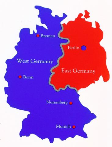
At Bonn was, during the Cold war and when the DDR still existed, the government of Western Germany located. Throughout the entire city, you will find all kinds of reminders of that time. And I forgot to mention the previous day, but you passed the Ahr stream which leads along Ahrweiler, where the Regierungsbunker (Government Bunker) was located. About 25 km south of Bonn, this massive, top-secret, 17.5 km long bunker complex was built between 1960 and 1972 in railway tunnels to house the government in a nuclear emergency. A 200-meter section is now a museum.
Key Cold War Structures in/around Bonn
- Bundeshaus (Federal Parliament) Situated along the Rhine, this complex served as the seat of the Bundestag and Bundesrat, featuring the iconic plenary chamber designed by Günter Behnisch.
- Palais Schaumburg The neoclassical primary seat and residence of the Federal Chancellor from 1949 to 1976.
- Villa Hammerschmidt: Served as the secondary official seat of the President of the Federal Republic of Germany.
- Civil Defense Bunkers: Numerous Cold War-era bunkers (e.g., at Lotharstrasse, Quirinusplatz) were constructed or upgraded, often combined with parking garages or subway systems.
- Embassy District (Bad Godesberg): Many nations maintained embassies in this district, characterized by high security, such as the former US Embassy.
- Haus der Geschichte (House of History): While now a museum, its exhibits focus on the history of the Federal Republic and the Cold War era
It is a shame, however, that there is no marina (or mooring spots) available in Bonn but there is one nearby: Rhein-Yacht-Club Niederkassel-Mondorf e.V. (approx. KM 660). From here it is a short travel (30 minutes) by public transportation to Bonn.
The route of today
On this section of the route you will pass the objects:
Nearby Services - Rheinau-Sporthafen Köln (Rheinauhafen)
-
Closest Supermarket: REWE
Location: Severinstraße 197, 50676 Köln
Distance: Approx. 850m (11-minute walk from the marina)
Best for: Full grocery range and fresh bread; located in the lively Severinsviertel district. -
Main Supermarket: HIT Markt
Location: Siegburger Str. 229 (Deutz side) or **Edeka** (Friedrichstraße)
Distance: Approx. 1.2 km (15-minute walk)
Best for: Massive selection and extensive provisioning; Edeka is closer for high-quality fresh produce. -
Note on Fuel: Rare Waterside Refueling Station
Status: This marina features its own **active waterside fuel station** for boats.
Available: Diesel and Super gasoline are typically available directly at the quay.
Recommendation: It is one of the most convenient fueling stops on the Rhine. Check seasonal hours at the harbor office, as they may vary.
Downstream to Düsseldorf 🇩🇪
Day 3: Closer to Turtle & Tiger
Further down the Rhein 🇩🇪
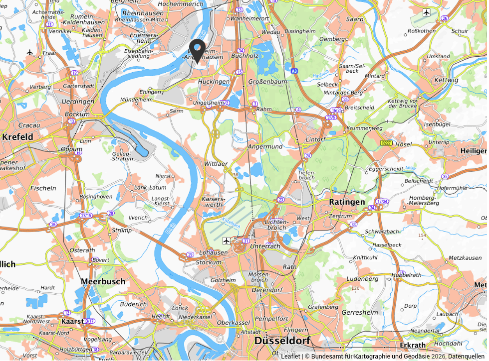
Depending on how fast the flow of the Rhein is, the speed (SOG) will be increased by that. By leaving the marina, we have to cross over to the other side of the river. Due to the higher speed of the currents you MUST make sure that you can cross safely! Use your AIS, you Marine Radio and your extra eyes. And yes, that routine has not changed magically!
Along this stretch, the entry to the harbours of NEUSS are on the left bank of the Rhein river. This implies that there is a lot of commercial traffic! Be aware and look at your surroundings!
Turtle & Tiger
In between Düsseldorf and Duisburg is on the right bank, Tiger & Turtle is located. This is one of the first trips that we took on our Piagio MP3! So maybe we will add an extra stop to visit it again. It is certainly a fun site to visit. For certain, bring your camera!
Düsseldorf Airport
If you are in a hurry to go somewhere, you can catch a flight from the airport here! Düsseldorf Airport has international flights.
The route of today
On this section of the route you will pass the objects:
Nearby Services - Marina Düsseldorf
-
Closest Supermarket: Netto Marken-Discount
Location: Hammer Straße 30, 40219 Düsseldorf
Distance: Approx. 850m (11-minute walk from the marina)
Best for: Daily groceries and fresh bread; located right on the edge of the Unterbilk district. -
Premium Shopping: REWE Markt
Location: Bilker Allee 57, 40219 Düsseldorf
Distance: Approx. 1.3 km (16-minute walk)
Best for: A larger selection of high-quality groceries and regional specialties. -
Note on Fuel: No Waterside Station
Status: There is no dedicated marine fuel station directly at the marina docks.
Nearest option: Aral (Völklinger Straße) or Shell (Gladbacher Straße).
Distance: Approx. 1.5 km walk.
Recommendation: These road stations are accessible by foot, but it is a longer trek. It is recommended to use a trolley for jerrycans or plan fuel stops in larger hubs with water access.
Downstream to Wesel 🇩🇪
Day 4: Closer to the Dutch Border
Further down the Rhein 🇩🇪
Depending on how fast the flow of the Rhein is, the speed (SOG) will be increased by that. By leaving the marina, we have to cross over to the other side of the river. Due to the higher speed of the currents you MUST make sure that you can cross safely! Use your AIS, you Marine Radio and your extra eyes. And yes, that routine has not changed magically!
Along this stretch, the entry to the harbours of NEUSS are on the left bank of the Rhein river. This implies that there is a lot of commercial traffic! Be aware and look at your surroundings!
The route of today
On this section of the route you will pass the objects:
Nearby Services - Yacht Club Wesel (YCW) / Stadthafen
-
Closest Supermarket: EDEKA Lurvink
Location: Kreuzstraße 11-13, Wesel
Distance: Approx. 2.8 km (8-minute bike ride or 35-minute walk)
Best for: High-quality groceries, fresh regional produce, and a large selection of items. -
Alternative Supermarket: REWE Markt
Location: Friedrichstraße 8, Wesel
Distance: Approx. 4.1 km (10-minute bike ride or 12-minute taxi)
Best for: Comprehensive provisioning and extended opening hours (usually until 10:00 PM). -
Note on Fuel: No Waterside Station
Status: There is no dedicated marine fuel station directly at the harbor docks.
Nearest option: Shell Station (Flürener Weg 84).
Distance: Approx. 2.5 km (30-minute walk or 7-minute drive).
Recommendation: Refueling is best done using a bike or taxi with jerrycans, as the road stations are a significant walk from the marina area.
Downstream to The Netherlands 🇳🇱
Day 5: Crossing the Dutch Border 🇩🇪 → 🇳🇱 →
From Rhein 🇩🇪 to Rijn 🇳🇱
Depending on how fast the flow of the Rhein (Rijn) is, the speed (SOG) will be increased by that. By leaving the marina, we have to cross over to the other side of the river. Due to the higher speed of the currents you MUST make sure that you can cross safely! Use your AIS, you Marine Radio and your extra eyes. And yes, that routine has not changed magically!
Along this stretch, the BORDER will be crossed into The Netherlands 🇳🇱
The route of today
On this section of the route you will pass the objects:
To the Rhein Days Index
Welcome back to The Netherlands!
Crossing the border →
Passing Marker 862.3 (DE)
Support the KNRM!
Help them to help others!
I would like to ask you to become a donor for the KNRM.
The KNRM is a fully private organisation, completely run by volunteers, financed by contributions and donations. You will find all information about them on the website.
You can choose from a single one time payment or a monthly or yearly donation. Please Support them.
Our personal opinion is that every person out on the water should, by law be told to make a donation of €25,- per year. But that is just our opinion.
Copyright, Disclaimer & Attribution
The legal stuff needed because of stupid....
The content on this website may include materials such as text, images, videos, and other media that are the property of their respective owners. All trademarks, logos, and copyrighted works remain the intellectual property of their original creators.
We strive to properly attribute and acknowledge all sources. If you are the copyright owner of any material featured on this site and believe it has been used without appropriate credit or permission, please contact us at [your contact email] so we can promptly address the issue.
Where applicable, the use of third-party content falls under fair use, creative commons licenses, or other applicable legal provisions. If specific attribution is required, it is provided directly alongside the respective material.
The images and data on this site are NOT intended for navigation or critical decision-making. Any reliance on this information is strictly at your own risk. The information on this site is for PERSONAL USE ONLY. You may print or copy parts of it for your own private use. Commercial use is strictly FORBIDDEN. Do not sell, rent, or use this data for profit. Unauthorized commercial exploitation will be met with rigorous legal action to the fullest extent of the law Furthermore, automated data scraping, harvesting, or feeding this content into large language models or AI systems is strictly PROHIBITED. If automated tools crawl this site without express written permission, access will be blocked, and those responsible will be held liable for unauthorized bandwidth usage and intellectual property infringement.
Powered by Haringstad
Build with VIM
© Haringstad, J and S van Koll