From Toul to Strasbourg
From Toul to Strasbourg
Part of the Boucle de Nancy to Strasbourg 🇫🇷
This route is inspired by talking to Virginia en John, who told us that another of their wishes is to do almost the same trip as the "Meuse → Mosel → Rhine" route, but then at Toul choose to head for Strasbourg 🇫🇷 and from there a small stretch Rhine to Mannheim and then head on the Neckar 🇩🇪 river to Heidelberg.
But busy as they are with making more surprises, they aren't planning anything yet and we looked at the map and thought: This isn't too much extra work(1), so we decided to document the route from Toul 🇫🇷 towards Strasbourg 🇫🇷 for them, so they have already a good basis to start with.
But besides that, it is also a very good detour route when the Moselle towards Frouard is blocked
Start point
It is safe to assume that you made it to Toul and that you found the intersection of Canal de la Marne au Rhin, branche Ouest with the Moselle Canalisée because this is where this route starts. So it does NOT start at the marina at TOUL
The regular route, or the Boucle de Nancy 🇫🇷?
When leaving Toul, the default route is heading east, towards Frouard. But facing a detour on this section, should not cause a problem. Because, by using the Boucle de Nancy heading west in the upstream on the Moselle, brings you counter clockwise on this loop. Here you can enter Canal de Jonction de Nancy and get back on the route to Strasbourg.
A technical highlight of the loop is the Canal de Jonction de Nancy. This 10-kilometer waterway features 18 locks, bridging a significant elevation change between the Meurthe and the Moselle rivers. It is a feat of hydraulic engineering where the classic Freycinet dimensions (38.5m x 5.1m) are the standard, providing a fascinating contrast to the nearby river locks that can handle vessels up to 187 meters long.
NOTICE: On this 10 km stretch there are hardly any mooring places, besides those at the locks! You have to be aware of this, taking your fuel and food in consideration!
Starting at Toul, where the Moselle and the Canal de la Marne au Rhin converge, navigators travel through a landscape steeped in history. From Vauban’s fortifications in Toul to the UNESCO-listed Place Stanislas in Nancy, the route offers a perfect balance between relaxed river cruising and active lock navigation, supported by a modern network of marinas like Port de France and Nancy-Saint-Georges. Those are the only larger marina's. The others along the route are truly just bare mooring places. After the intersection at Canal de Marne au Rhin Est with Canal de Jonction de Nancy this will change.
Heading to Frouard
Attention! Make sure you did get fuel before leaving Toul! From here on the locations to refuel are pretty scarse and you don't want to get stuck somewhere in the middle of nergenshuizen. Also, we are not going to explain the counter clockwise route of the Boucle de Nancy here, because that is already covered in one of our other routes.
Leaving Toul, turn port (left) on to the Moselle. From here to Frouard, Nancy and finaly Strasbourg. So we travel first over La Moselle Canalisée and then Canal de la Marne au Rhin Est. But also the Canal des Houillères de la Sarre(2) for about 2 km. A nice Port de Plaisance is located there, almost in the middle of Lagarde and Hesse.
Which waterways on this route?
This route uses three(3) waterways in between Toul and Strasbourg:
Navigate from Toul to Strasbourg
From Toul to Nancy: East or West?
The LOOP de Nancy
Which way to go?
Leaving Toul, there are two options to get back to the Canal de la Marne au Rhin Est: Heading East, or heading west on La Moselle Canalisée. Both are valid options because these are both parts of the (LOOP) Boucle de Nancy. The general advice is to head east, towards Frouard, because on this stretch there are decent options to stay the night. Doing the west stretch, means passing the Canal de jonction de Nancy which does not have any well utilised marina's or stops. And you have to go back to Nancy for a decent Marina/Halte Fluviale.
Whenever you choose, or are forced to use the Boucle de Nancy counter clockwise, make sure that you have enough food and fuel!
We assume that the route eastward on La Moselle Canalisée 🇫🇷 is not blocked, and therefore we start in that direction.
The route on the two waterways for today
On these routes, you will pass the objects:
Leaving La Moselle Canalisée 🇫🇷 and entering Canal de la Marne au Rhin Est 🇫🇷
ATTENTION! This is where the second waterway entrance is on the right bank. Pay attention to traffic. First pass the intersection and make a U-turn a little down-stream of the intersection. Get into the Canal by heading upstream. Pay attention to Commercial shipping!
Nearby Services - Port de plaisance Bassin St-Georges Nancy
-
Closest Supermarket (Convenience): Carrefour City
Location: 26 Rue Saint-Georges, Nancy
Distance: Approx. 450m (6-minute walk)
Best for: Quick supplies and fresh groceries in the city center. -
Largest Supermarket: E.Leclerc
Location: 3 Prom. Emilie du Châtelet, Nancy
Distance: Approx. 700m (9-minute walk)
Best for: Bulk shopping and a wider variety of products; very close to the basin. -
Nearest Gas Station: Esso Express
Location: 47 Bd Jean Jaurès, Nancy
Distance: Approx. 1.6 km (20-minute walk or short drive)
Service: 24/7 automated pumps providing Diesel (Gazole) and Unleaded gas.
Note: Land-based station; accessible for fuel cans (jerrycans).
From Nancy to Einville-aux-Jard
Passing LOOP de Nancy
Leaving Nancy for Einville-au(x)-Jard?
Leaving Nancy, we are heading to the intersection with the (LOOP) Boucle de Nancy. Leaving the intersection to Canal de Jonction de Nancy on our starboard side, we get onto the industrial stretch of this route. For some kilometers the salt industry will be dominating the area (Solvay, amongst others). This section will try to get you to the next nice mooring place with services and utilities. And for now, Einville-au-Jard looks like that place.
The route of today
On this route, you will pass the objects:
Nearby Services - Port de plaisance Einville-au-Jard
-
Closest Supermarket (Convenience): Proxi
Location: 60 Grande Rue, Einville-au-Jard
Distance: Approx. 450m (6-minute walk)
Best for: Fresh produce and daily grocery needs within the village. -
Nearest Bakery: Aux Délices d'Einville
Location: 9 Pl. de la Fontaine, Einville-au-Jard
Distance: Approx. 400m (5-minute walk)
Best for: Fresh baguettes, artisanal pastries, and local specialties. -
Largest Supermarket: E.Leclerc
Location: 2 Rue de l'Abbé de l'Épée, Lunéville
Distance: Approx. 8 km (10-minute drive)
Best for: Bulk shopping and a wider variety of products in the nearby city. -
Nearest Gas Station: TotalEnergies
Location: 60 Bd Georges Pompidou, Lunéville
Distance: Approx. 7.5 km (9-minute drive)
Service: 24/7 automated pumps providing Diesel (Gazole) and Unleaded gas.
Note: Land-based station; accessible for fuel cans (jerrycans).
Einville-aux-Jard to Lagarde
Enjoying Nature along the route
Shorter distance, longer boating
After Einville-au-Jard the area becomes way more agricultural. This implies more nice views, but also lack of large(r) stores and gas-stations. This section takes us to Lagarde.
The route of today
On this route, you will pass the objects:
Nearby Services - Port Fluvial de Lagarde
-
Closest Supermarket (Convenience): Capitainerie Shop
Location: Port de Lagarde, 57810 Lagarde
Distance: Directly at the marina
Best for: Basic groceries, regional products, and essential supplies available at the port office. -
Nearest Bakery: Boulangerie Dépôt (Port Office)
Location: Port de Lagarde (Capitainerie)
Distance: Directly at the marina
Best for: Fresh baguettes and croissants; usually available by ordering the evening before at the capitainerie. -
Largest Supermarket: Intermarché SUPER
Location: Avenue de Lunéville, Dieuze
Distance: Approx. 11 km (12-minute drive)
Best for: Full grocery shopping and a wider variety of products in the nearby town of Dieuze. -
Nearest Gas Station: Intermarché Station-service
Location: Avenue de Lunéville, Dieuze
Distance: Approx. 11 km (12-minute drive)
Service: 24/7 automated pumps providing Diesel (Gazole) and Unleaded gas.
Note: Land-based station; accessible for fuel cans (jerrycans).
Lagarde to Port du Houillon
Nature around us along the route
According to documentation, a 5 hour trip
Leaving Lagarde, passing Halte Nautique de Maizières-lès-Vic (Port sainte-Marie) after just a couple of km, the view will be completely different. After km 220 (Pont de l'Etang) the water will be way wider for a little while, and the surroundings will be more forrest-like. This will continue upto Gondrexange. But before we get there the route takes us to Port du Houillon, 2 km up Canal des Houillères de la Sarre.
You can choose to stay at Gondrexange if you wish, but according to our information there are no services (water, electricity) available there.
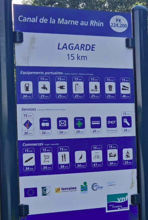
VNF Info Panels
During the trip you might (or might not) see these type of information panels. And the first time we did look at them, they where a bit hard to understand. But it is actually simple. You see on top "Lagarde" with the amount of KM. (15 km). Then below that, you see the services: Gas, Water, etc. And on top and/or below those icons you see distances in KM. In this case, the 15 KM on top of each icon points to "Lagarde, 15KM". So the distance on top of the icon, is referring to the place on top of the information panel.
As you can see on the image, they also provide how far it is to the next gas station.
The routes of today
On these routes, you will pass the objects:
Nearby Services - Port du Houillon (On Foot)
-
Closest Supplies: Capitainerie Mini-Shop
Location: Directly at the marina office
Distance: 0 km (On-site)
Best for: Very basic food items, local regional products (like Mirabelle plum jam), and drinks. Note: Stock is limited, especially outside the high season. -
Fresh Bread: Bread Service (Capitainerie)
Location: Port Office
Distance: 0 km (On-site)
Best for: Fresh baguettes and croissants.
Important: You must usually pre-order your bread at the harbor master the evening before. -
Nearest Dining: Local Restaurants
Location: Various (limited)
Distance: Walking not recommended for groceries.
Note: There are no large supermarkets or independent bakeries within reasonable walking distance. It is highly recommended to stock up at a previous stop.
Port du Houillon to Port Plaisance Marina Niderviller / Altmuehl
Heading for the tunnels
Short day before the tunnels
After Houillon, with its silence and wide view1 over nature, the route takes us towards the last marina before the two tunnels on this canal. It is not a long stretch, but brings us precicely at the entrance of Souterrain Niderviller. Here we can taken some time, and get fuel. Niderviller is at the edge of the Vosges Mountain ridge
1When you are from the Netherlands, then this is still a restricted view towards the horizon
The routes of today
On these routes, you will pass the objects:
Nearby Services - Port Plaisance de Niderviller / Altmuehl
-
Closest Supermarket (Convenience): Proxi Niderviller
Location: 26 Rue de Lorraine, 57565 Niderviller
Distance: Approx. 800m (10-minute walk)
Best for: Daily groceries, fresh products, and general essentials. It's a small but well-stocked village shop. -
Nearest Bakery: Boulangerie Stinus / Girardin
Location: 1 Rue de la Paix, 57565 Niderviller
Distance: Approx. 900m (11-minute walk)
Best for: Fresh French baguettes, pastries, and croissants. A classic local bakery right in the heart of the village. -
Largest Supermarket: Intermarché CONTACT Lorquin
Location: 1 bis Rue du Général de Gaulle, 57790 Lorquin
Distance: Approx. 4.5 km (Too far for a comfortable walk)
Best for: Extensive shopping. If you only have your legs, stick to the local Proxi in Niderviller. -
Nearest Gas Station: Intermarché Station-service
Location: Lorquin (Near the Intermarché)
Distance: Approx. 4.5 km
Note: Not reachable on foot with heavy jerrycans. Check at the marina office if they have local fuel services or a shuttle.
Marina Niderviller to Lutzelbourg
The tunnels and the Elevator (boatlift)
Tunnels and an elevator this stretch!
Today will be a day with some extremes. Like, there will be tunnels, an boat-elevator and locks on our way to Lutzelbourg. (No, not Luxembourg!) Actually, this will be pretty much spectaculair because of the height of 44,55 meter of elevator-ride and a total of approx 2800 meters of tunnels.
Getting down on the 44,55 meters with the elevator, only takes approx. 4 minutes! The Saint-Louis-Arzviller Inclined Plane, often called the "Arzviller boat lift," is a unique piece of civil engineering located on the Marne-Rhine Canal in Moselle, France. Commissioned in 1969, it was designed by engineer Robert Vadot to replace a ladder of 17 locks that previously required an entire day of navigation.
When exiting the Soutterain d'Arzwiller, the steep valley walls (over 350 Meters) will grab the attention.
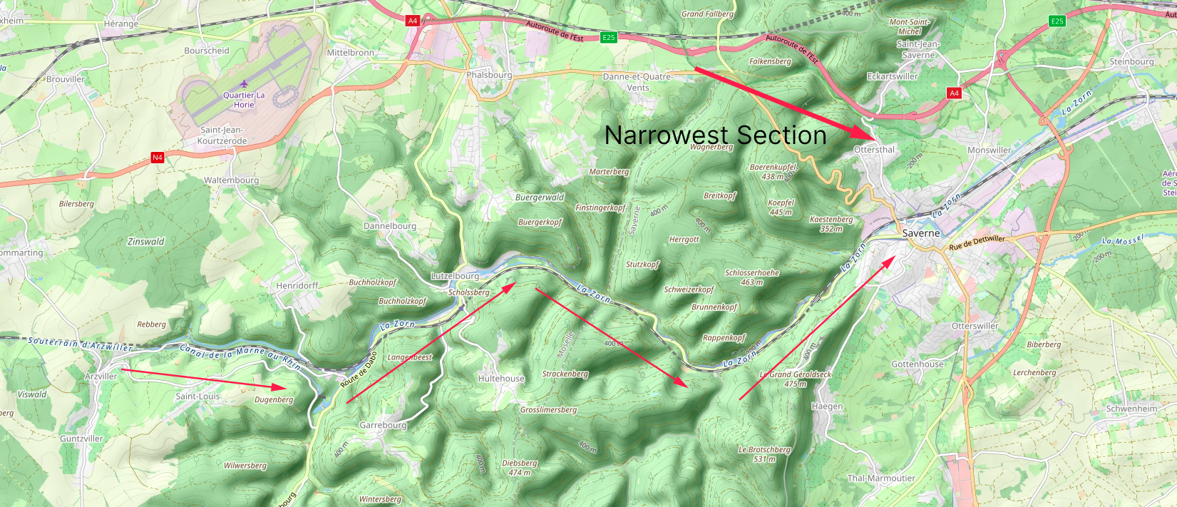
But before we get there, we start immediately after leaving the marina, with a tunnel. Entering the tunnel means leaving Pays des Étangs (Land of Ponds), where agriculture and soft slopes define the area. Leaving the tunnels means bringing us within the forrested mountain region of the Vogesen (Les Vosges) mountain ridge that is parallel to the Rhine river. The route crosses the almost narrowest part of the mountain-ridge. (The narrowest is just a few km north, where the A4/E25 is passing).
VNF Information for this section (20-03-2025)
VNF will continue the SCUO remote control trial this season on the section between Saverne and the Arzviller Inclined Plane, where staff will distribute the devices to unequipped waterway users at lock 30/31 or the Inclined Plane and collect them upon their exit from the sector.
The route of today
On the route, you will pass the objects:
Nearby Services - Port de Plaisance de Lutzelbourg
The town of Lutzelbourg is crammed between the mountains surrounding it. Not leaving much space for large stores. And also, the size of the town is not supportive of a large supermarket. Therefore only basic stuff can be bought.
-
Closest Grocery Store: Union des Coopérateurs d'Alsace (Proxi/Tabac)
Location: 5 Rue de Phalsbourg, 57820 Lutzelbourg
Distance: Approx. 350m (4-minute walk)
Best for: Basic groceries, newspapers, and everyday essentials. It is a small "Tabac" style mini-mart, so stock is limited to the basics. -
Nearest Bakery: Boulangerie Patisserie Ruby
Location: 4 Rue de Dannelbourg, 57820 Lutzelbourg
Distance: Approx. 500m (6-minute walk)
Best for: Fresh artisanal bread, traditional baguettes, and local pastries. -
Largest Supermarket: E.Leclerc Saverne / Marmoutier
Location: Saverne (Next major town)
Distance: Approx. 10 km (Not walkable)
Note: For a full "hypermarché" experience, you would need a taxi or wait until your next stop in Saverne, where large stores are more accessible. -
Nearest Fuel/Service: Locaboat Base Lutzelbourg
Location: 7 Rue de la Zorn (Port Amont)
Distance: 0 km (Directly at the marina)
Service: Fuel (Diesel) and water are usually available at the hire bases (Locaboat or others) for visiting boats.
Note: If you need a standard gas station for small amounts/jerrycans, the nearest road-side station is several kilometers away towards Phalsbourg.
Lutzelbourg to Saverne
From halfway Vosges
Leaving the Vosges Mountains Ridge, and a double(4) lock!
Today will not be such an exiting day as yesterday unless you discount the environment and views. Techincally, only some locks and one place for major groceries. But our eyes will enjoy enough from the tight valley passing. The valley that La Zorn created and which is followed to create the passage trough for the canal.
Exiting the mountain-ridge is very obvious. From here the land will be just villages with rolling fields, in contrast to the forrested mountain slopes between which we have just navigated
VNF Information for this section (20-03-2025)
VNF will continue the SCUO remote control trial this season on the section between Saverne and the Arzviller Inclined Plane, where staff will distribute the devices to unequipped waterway users at lock 30/31 or the Inclined Plane and collect them upon their exit from the sector.
Saverne - Groceries
In the city of Saverne is, about 750 meters from the marina, a large supermarket: Super U and Drive. Here you find all the major grocery products you might need. There are also some gas stations at walking distance. And we suggest that you get enough here because along the route, there are very sparse options to get groceries.
The route of today
On the route, you will pass the objects:
Nearby Services - Port de Plaisance de Saverne
-
Closest Supermarket: Carrefour City
Location: 3 Rue Raymond Poincaré, 67700 Saverne
Distance: Approx. 450m (6-minute walk)
Best for: Comprehensive daily groceries, fresh produce, and drinks. It is very close to the marina and convenient for carrying bags back to the boat. -
Nearest Bakery: Boulangerie Reutenauer
Location: 79 Grand Rue, 67700 Saverne
Distance: Approx. 400m (5-minute walk)
Best for: Fresh baguettes, local Alsatian pastries (Kougelhopf), and sandwiches. Located in the main pedestrian street. -
Largest Supermarket: Auchan Supermarché
Location: 61 Rue de Dettwiller, 67700 Saverne
Distance: Approx. 1 km (12-minute walk)
Best for: Large stock-ups and a wider variety of non-food items. Still walkable, but a bit further than the Carrefour City. -
Nearest Fuel/Service: Marina Fuel Station
Location: Directly at the port (managed by the Capitainerie)
Distance: 0 km (On-site)
Service: Diesel and fresh water are available at the fuel pontoon within the marina.
Note: The marina office (Capitainerie) also offers bike rentals and laundry facilities (washing machine/dryer).
More peaceful place?
By any chance, if you are looking for a more peaceful place to spend the night? Continue then to Halte Nautique de Steinbourg which is 5 locks and 4.5 km further along the canal.
Saverne to Waltenheim sur Zorn
to halfway to Strasbourg
Heading to half ways
Many half ways.... We know.
Notice: Please make sure that you have done enough groceries for the coming days! From here to, at least the suburbs of Strasbourg, there will be only distant, or none at all, places to do groceries!
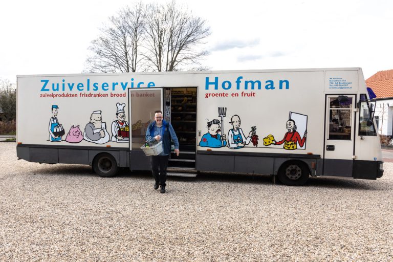
The quay at Waltenheim sur Zorn is a pretty new environment. Somewhere between 2012 and 2019, large scale improvements have been made to the quay here. Where there where only a couple of bolders and grass in 2012, by 2019 you can see the change that there is a beautiful concrete quay with electricity and water! So, huge improvements have been made to the quay that you now can profit from. The only downside of this location is that there is no groceries shop, or bakery. Maybe a "SRV Truck" concept would work (https://www.hofman-zuivel.nl: Like in the Netherlands the SRV Concept) Specifically bringing the produce to the customer can be a large win-win. here during the boating season?
The route of today
On the route, you will pass the objects:
Nearby Services - Halte Nautique de Waltenheim-sur-Zorn
-
Best Dining Option: Restaurant À l'As du Pigeon
Location: 1 Rue de la Marne, 67670 Waltenheim-sur-Zorn
Distance: Approx. 800m (10-minute walk uphill from the canal)
Best for: Famous local Tarte Flambée (Flammkuchen). This is the main reason boaters stop here. -
Note on Groceries & Bread: No local shops
Status: There are currently no active bakeries or supermarkets within walking distance in the village center.
Advice: It is essential to have enough supplies on board before arriving at this stop. -
Nearest Full Supermarket: Super U Hochfelden
Location: Hochfelden (Next town)
Distance: Approx. 6 km
Note: Only accessible by bike or taxi. Not recommended on foot. -
Port Facilities: Halte Nautique
Location: Quai du Canal
Service: Water and electricity are available at the quay (managed by the community of communes).
Waltenheim sur Zorn to Strasbourg
Arriving at Strasbourg
Arriving at Strasbourg
The intersection with the Rhine. The stop before we turn onto the Rhine river, north to wards the intersection with the Neckar river.
Notice: Within Strasbourg there is a marina with a
gas station/pump
Tankstation / bunkerstation Strasbourg
Europe Boat Trading, Quai des Belges 6, Strasbourg, Telefoon: +33 (0)3 88 61 26 78
at the water.
Marina's in Strasbourg
Fact is, that there are several, smaller and medium sized, marina's in Strasbourg. Although they are very nicely situated towards the water, they aren't situated truly close to the (old) city center. There are the following available:
- Plaisance Club de Strasbourg: Located close to the Rhine river, outside of the last lock of the canal. About 4,7km (1 hour) walk to the Cathedral of Strasbourg.
- Europe Boat Trading: Located at the banks of the Rhone - Rhine canal. About 2,5 km (35 minute) walk to the Cathedral of Strasbourg.
- Port de Plaisance de Strasbourg: Located in one of the old industrial harbors south of Strasbourg. About 7km (1,5 hour) walk to the Cathedral of Strasbourg.
We suggest to see if Europe Boat Trading has place. And else there might be, just around the corner of them, a place along a quay.
Additional option!
When you still want to visit Strasbourg, but are more or less bound by challenges, then the marina in Germany
(just across the Rhine) at Rhine KM 293,8
Nautic Club Kehl
Nautic Club Kehlbr>Hafenstraße 3
Kehl
Telefoon: +49 (0)174 3461 898
www.nautic-club-kehl.de
From here, within 30 minutes with public transportation you are at the Cathedral of Strasbourg:
10 min/600m walk from Marina to Bahnhof
20 min Tram from Kehl Bahnhof to Langstross Grand'Rue in Strasbourg. Priority spaces for wheelchairs/boosters
5 min/500m walk from Langstross Grand'Rue to the Cathedral.
might be an option. Seen the services of Marina Kehl and the transportation options, we think that this is your
best option for a pleasant stay.
The route of today
On the route, you will pass the objects:
Crossing the rhine to Kehl
Because all places within Strasbourg are pretty much limited or distant from the city-center, we advise you to cross the Rhine and stay at the marina at Kehl. At Kehl, mobility is way better and immensly closer to the marina, than the options within Strasbourg. The section below will describe how to get to Kehl in a safe and controlable manner.
Strasbourg to Kehl -
Hopping over the Rhine -
Crossing the Rhin/Rhein 🇫🇷/🇩🇪
Welcome to Germany!
Crossing the Rhine at Strasbourg
The question might arise: Why cross the Rhine and stay in Germany? The answer is simple: The infrastructure of the marina at Kehl is better utilised than the ones inside Strasbourg and from the marina in Kehl the city of Strasbourg is very easy to visit by means of public transportation!
Crossing the Rhine
There are two options to cross the Rhine at Strasbourg:
- North side: When you follow the Canal de la Marne au Rhin to the Rhine at PK 295.8
Use this option when the current is below 6 km/h so you have enough speed to comfortably navigate going upstream. From this intersection it is approx. 2 km upstream to the entrance of the Marina. The advantage of taking this intersection is that you don't have to turn around on the Rhine to enter the entrance with the current against. - South side: Behind the locks of the Canal du Rhone au Rhin and the Bassin Rene Graff (Ecluse Sud) at PK 291.0.
Use this option when the current is faster than 6 km/h, and turn already upstream of the train-bridge and use the current to take you to the entrance of the marina. This is an move that experienced boaters will not have a problem to execute.
We suggest to check at the date of crossing, what the speed of the current in the Rhine is, before you decide which of the two you use. Using the Nort side means that you will have to navigate approx 2 km going upstream.
Important!
You must enter harbors or intersections on a fast floating river, heading upstream! Failing to do so You should ALWAYS enter a harbor, or intersection, going upstream! Failing to do so will push you against the downstream corner of the bank! will cause an accident! And that is beyond any doubt!
Location: the location of Nautic Club Kehl is in between Écluse Nord and Écluse Sud. Not exactly in the middle but a bit closer to Écluse Nord (2 km) than Écluse Sud (2.8 km).
The route of today going upstream
On this route upstream, you will pass the objects:
The route of today going downstream from Ecluse Sud
On this route downstream, you will pass the objects:
Call the marina at Kehl
We advice to call the marina at Kehl to reserve a place.
Support the KNRM!
Help them to help others!
I would like to ask you to become a donor for the KNRM.
The KNRM is a fully private organisation, completely run by volunteers, financed by contributions and donations. You will find all information about them on the website.
You can choose from a single one time payment or a monthly or yearly donation. Please Support them.
Our personal opinion is that every person out on the water should, by law be told to make a donation of €25,- per year. But that is just our opinion.
Copyright, Disclaimer & Attribution
The legal stuff needed because of stupid....
The content on this website may include materials such as text, images, videos, and other media that are the property of their respective owners. All trademarks, logos, and copyrighted works remain the intellectual property of their original creators.
We strive to properly attribute and acknowledge all sources. If you are the copyright owner of any material featured on this site and believe it has been used without appropriate credit or permission, please contact us at [your contact email] so we can promptly address the issue.
Where applicable, the use of third-party content falls under fair use, creative commons licenses, or other applicable legal provisions. If specific attribution is required, it is provided directly alongside the respective material.
The images and data on this site are NOT intended for navigation or critical decision-making. Any reliance on this information is strictly at your own risk. The information on this site is for PERSONAL USE ONLY. You may print or copy parts of it for your own private use. Commercial use is strictly FORBIDDEN. Do not sell, rent, or use this data for profit. Unauthorized commercial exploitation will be met with rigorous legal action to the fullest extent of the law Furthermore, automated data scraping, harvesting, or feeding this content into large language models or AI systems is strictly PROHIBITED. If automated tools crawl this site without express written permission, access will be blocked, and those responsible will be held liable for unauthorized bandwidth usage and intellectual property infringement.
Powered by Haringstad
Build with VIM
© Haringstad, J and S van Koll